
named after the city of České Budějovice. It is known as a cultural landscape with numerous ponds. The České Budějovice Basin is one of the mesoregions...
5 KB (488 words) - 09:24, 24 February 2023

urban monument reservation. České Budějovice is made up of seven city parts named České Budějovice 1–7. České Budějovice 5 forms an exclave of the municipal...
36 KB (3,351 words) - 04:42, 13 July 2024

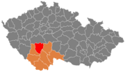
České Budějovice District (Czech: okres České Budějovice) is a district in the South Bohemian Region of the Czech Republic. Its capital is the city of...
15 KB (887 words) - 01:32, 13 July 2024

České Budějovice and Třeboň basins. The most prominent localities are concentrated in a NW-SE strip along the western margin of the České Budějovice Basin...
11 KB (1,174 words) - 18:56, 22 May 2024

about 18 kilometres (11 mi) northwest of České Budějovice. It lies in a flat landscape in the České Budějovice Basin. There are several fishponds in the municipal...
7 KB (494 words) - 13:26, 10 June 2024

level. The northeastern part with Holubovská Bašta lies in the České Budějovice Basin and is rich in fishponds. The Dehtář pond, which is among the largest...
5 KB (320 words) - 08:47, 10 June 2024

located about 4 kilometres (2 mi) southwest of České Budějovice. It lies in the České Budějovice Basin. The Vltava river forms the southern and eastern...
5 KB (289 words) - 13:26, 10 June 2024

Litvínovice (category Villages in České Budějovice District)
Litvínovice is located about 1 kilometre (1 mi) west of České Budějovice. It lies in the České Budějovice Basin. The highest point is at 458 m (1,503 ft) above...
5 KB (285 words) - 12:43, 10 June 2024

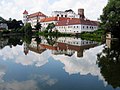
Hluboká nad Vltavou (category Populated places in České Budějovice District)
Hluboká nad Vltavou is located on the railway lines České Budějovice–Písek and České Budějovice–Strakonice. The Townshend International School has been...
10 KB (870 words) - 19:26, 9 June 2024
central part of the South Bohemian Region consists of the České Budějovice Basin and Třeboň Basin. The southwest consists of the Bohemian Forest mountain...
20 KB (1,668 words) - 14:52, 17 May 2024

Zliv (category Populated places in České Budějovice District)
about 12 kilometres (7 mi) northwest of České Budějovice. It lies in a flat landscape in the České Budějovice Basin. The town is situated on the shores of...
5 KB (311 words) - 06:14, 12 June 2024

inhabitants. Adamov is located about 5 km (3 mi) east of České Budějovice. It lies in the Třeboň Basin. The highest point is at 579 m (1,900 ft) above sea...
4 KB (127 words) - 08:45, 10 June 2024

Temelín (category Villages in České Budějovice District)
territory with the villages of Lhota pod Horami and Sedlec lies in the České Budějovice Basin. The highest point is a hill at 525 m (1,722 ft) above sea level...
7 KB (531 words) - 06:15, 12 June 2024

Vltava (category Vltava basin)
Bohemian Forest and then north across Bohemia, through Český Krumlov, České Budějovice, and Prague, and finally merging with the Elbe at Mělník. It is commonly...
16 KB (1,490 words) - 20:23, 13 July 2024

51 kilometres (32 mi) northwest of České Budějovice. It lies mostly in the northern tip of the České Budějovice Basin, but the municipal territory also...
13 KB (1,010 words) - 20:28, 17 May 2024

Lišov (redirect from Lišov (České Budějovice District))
from České Budějovice to Tábor, part of the European route E55) runs along the western municipal border. The I/34 (the section from České Budějovice to...
7 KB (475 words) - 12:52, 10 June 2024

Písek and 30 km (19 mi) northwest of České Budějovice. Most of the municipal territory lies in the České Budějovice Basin, but the eastern part extends into...
7 KB (534 words) - 11:55, 12 July 2024

Včelná (category Villages in České Budějovice District)
located about 3 kilometres (2 mi) south of České Budějovice. It lies on the border between the České Budějovice Basin and Gratzen Foothills. The highest point...
5 KB (271 words) - 13:24, 10 June 2024
territory), Vlašim Uplands (northeast), Benešov Uplands (northwest) and České Budějovice Basin (south). The highest point of the district is the hill Kozlov in...
10 KB (602 words) - 01:33, 13 July 2024

fishpond system. The Třeboň Basin is one of the mesoregions of the South Bohemian Basins (the second being the České Budějovice Basin) within the Bohemian Massif...
6 KB (552 words) - 09:25, 24 February 2023

Doudleby, Plav, Vidov, Roudné and České Budějovice. The largest body of water on the Malše and in its whole basin area is the Římov Reservoir with an...
4 KB (374 words) - 15:25, 12 May 2024

Hradec and 41 km (25 mi) southeast of České Budějovice, on the border with Austria. It lies in the Třeboň Basin. The highest point is the flat hill Andělský...
8 KB (598 words) - 18:40, 30 June 2024

south of Písek and 40 km (25 mi) northwest of České Budějovice. It lies in the České Budějovice Basin. The highest point is the hill Zubovský vrch 442...
6 KB (420 words) - 08:19, 4 May 2024

Strakonice and 56 km (35 mi) northwest of České Budějovice. It lies on the border between the České Budějovice Basin and Blatná Uplands. The highest point...
6 KB (420 words) - 06:13, 3 June 2024

territory lies in the Tábor Uplands, but the southern part lies in the České Budějovice Basin. There are several steep streets and some suburbs lie more than...
18 KB (1,641 words) - 09:29, 17 May 2024

Srubec (category Villages in České Budějovice District)
southeast of České Budějovice. It lies mostly in the Třeboň Basin, on the western tip of the municipal territory extends into the České Budějovice Basin. The...
5 KB (296 words) - 13:27, 10 June 2024

Ševětín (category Populated places in České Budějovice District)
15 kilometres (9 mi) northeast of České Budějovice. It lies on the border between the Tábor Uplands and Třeboň Basin. The highest point is at 513 m (1...
7 KB (448 words) - 13:25, 10 June 2024

south of Písek and 34 km (21 mi) northwest of České Budějovice. It lies in the České Budějovice Basin. The highest point is at 450 metres (1,480 ft)...
6 KB (360 words) - 12:32, 28 February 2024

of Strakonice and 28 km (17 mi) northwest of České Budějovice. It lies mostly in the České Budějovice Basin. A small western part of the municipal territory...
10 KB (804 words) - 13:32, 2 June 2024

(north, centre and southeast), Bohemian Forest (south and west), and České Budějovice Basin (small part in the east). The highest point of the district is the...
12 KB (801 words) - 01:33, 13 July 2024