
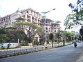
Khan Road, commonly known as 100 Feet Road Indira Nagar. It is a road in the Indian city of Bangalore that links Old Madras Road with Old Airport Road. 100...
4 KB (397 words) - 12:42, 28 June 2024

the road, beyond Old Airport Road from Domlur junction is called 100 Feet Road. The Inner ring road in Bangalore is link road connecting Indiranagar and...
4 KB (279 words) - 12:46, 28 June 2024

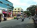
1990s converted Indiranagar and its two arterial roads (100 Feet Road and Chinmaya Mission Hospital Road) into a semi-commercial area. Today, Indiranagar...
8 KB (516 words) - 12:20, 28 June 2024
77.646°E / 12.96; 77.646 Old Airport Road is a major road in Bangalore, India. It was renamed from Airport Road after the new Bengaluru International...
4 KB (359 words) - 12:41, 28 June 2024

National Highway 1 (India) (redirect from 90 Feet Road)
Department of Road Transport and Highways. Archived from the original (PDF) on 1 February 2016. Retrieved 3 April 2012. Das 2021, p. 100. Kavic, Lorne...
7 KB (518 words) - 15:49, 15 February 2023
neighborhoods in Bangalore by region. In recent decades, the city has witnessed rapid growth in population and urbanized area. While Central Bangalore is the commercial...
21 KB (204 words) - 12:55, 28 June 2024

List of Namma Metro stations (redirect from Indiranagar (Bangalore Metro))
on 20 October 2011 between Baiyappanahalli and M.G Road. The system is operated by the Bangalore Metro Rail Corporation Limited (BMRCL). On 25 March...
49 KB (1,426 words) - 12:39, 6 June 2024

Namma Metro (redirect from Bangalore metro)
east–west tunnel of the Purple line between Cubbon Park and Magadi Road and Bangalore Metro Rail Corporation Ltd (BMRCL) began trials on 23 November 2015...
147 KB (14,782 words) - 22:29, 6 July 2024

floor. The station was named Mantri Square Sampige Road due to a PPP agreement between the Bangalore Metro Rail Corporation Ltd (BMRCL) and Mantri. Mantri...
13 KB (960 words) - 19:32, 2 April 2024
The Rice Memorial Church is located in the busy Avenue Road, Bangalore Pete. It is named after Rev. Benjamin Holt Rice, a missionary of the London Missionary...
28 KB (2,885 words) - 00:14, 6 June 2024

Basaveshwaranagara (redirect from Kamala Nagar, Bangalore)
location on the 1st Main Road, near to the Dr. Ambedkar stadium. It comes under the jurisdiction of West division DCP of Bangalore city and Vijayanagar division...
32 KB (2,906 words) - 02:33, 17 February 2024

Christ University (redirect from Christ College, Bangalore)
College and Christ University, is a deemed-to-be-university located in Bangalore, Karnataka, India. Founded in 1969 as Christ College, the University Grants...
24 KB (1,694 words) - 14:19, 10 July 2024

Tannery Road is located in the North East of Bangalore Cantonment, India. It is a 4 km long narrow road (about 40 ft. wide) with around 700 shops, named...
26 KB (2,190 words) - 00:32, 6 June 2024
New Horizon Public School (category Private schools in Bangalore)
private school located in Indiranagar, Bangalore, India. The New Horizon campus is situated on 100 Feet Road, Indiranagar. The students are divided into...
2 KB (159 words) - 12:46, 28 June 2024

Domlur (category Neighbourhoods in Bangalore)
to all parts of Bangalore by road. There are three arterial roads in the locality- Old Airport Road, 100 Feet Road and Inner Ring Road- which connect Domlur...
14 KB (1,000 words) - 12:35, 28 June 2024

Raggigudda-Silk Board Flyover (category Bridges and flyovers in Bangalore)
is being built by the Bangalore Metro Rail Corporation Limited between Central Silk Board and Ragigudda as part of the RV Road-Bommasandra Metro line...
3 KB (213 words) - 21:35, 23 February 2024
up public infrastructure buildings including bridges on the Honnavar–Bangalore road. In 1966, he shifted base from his native Uttara Kannada district to...
12 KB (1,089 words) - 17:20, 27 June 2024

Karnataka Tamils (redirect from Tamils in Bangalore)
Karnataka Tamils are a social community of Tamil language speakers living in Bangalore, capital city of the Indian state of Karnataka and Mysore, Mandya, Kolar...
26 KB (2,477 words) - 12:47, 28 June 2024

Purple Line and North-South corridor of Green Line of Namma Metro in Bangalore, in the state of Karnataka, India. It opened to the public on 30 April...
16 KB (904 words) - 05:39, 2 April 2024
Chrysalis High (category High schools and secondary schools in Bangalore)
chain of co-educational schools in Bangalore. The schools are located at: Varthur (Marathahalli – Sarajapur Road), started 2012, Yelahanka (New Town)...
5 KB (604 words) - 18:32, 12 August 2023
165 feet (50 meters) above the sea level. Barpeta Road is a Municipal Board city situated in Barnagar Circle of Barpeta district. The Barpeta Road city...
7 KB (774 words) - 13:10, 28 February 2024
Bangalore (Bengaluru), the capital of Karnataka state, India, reflects its multireligious and cosmopolitan character by its more than 1000 temples, 400...
63 KB (6,997 words) - 12:34, 2 June 2024
51 feet height Bahubali, but as it was to be transported from Bidadi, Bangalore to Gujarat, it was reduced to 41 feet due to concerns about road conditions...
6 KB (438 words) - 18:22, 21 April 2024
Indian Institute of Science (redirect from Indian Institute of Science Bangalore)
design, and management. It is located in the southern Indian city of Bangalore, Karnataka. The institute was established in 1909 with active support...
95 KB (7,317 words) - 07:38, 2 June 2024

cities in the region by road and by train. This includes National Highway 44, Bangalore Highway [KA SH 9], Parigi Road, Lepakshi Road National Highway 544E...
14 KB (1,064 words) - 06:30, 15 June 2024

Cooperative Society Building on Double Road built around 1930's built during British The Drinking Water Fountain at Bangalore Circle in front of the Guru Bhavana...
27 KB (2,285 words) - 01:07, 4 May 2024

Ultramarathon (category Road running distances)
2016 – via Facebook. "The Bangalore Ultra". The Bangalore Ultra. Retrieved 28 April 2013. "Big response for the Bangalore Marathon". The Hindu. 14 December...
84 KB (8,680 words) - 23:27, 11 July 2024
Arekere Lake (category Lakes of Bangalore)
of the city of Bangalore. Originally spread over an area of approximately 37 acres, the lake is bounded on the west by Bannerghatta Road, on the north...
6 KB (503 words) - 15:22, 17 February 2024
Japanese people in India (section Bangalore)
outside Bangalore for Japanese manufacturers. The Department of Foreign Languages at Bangalore University teaches Japanese.[citation needed] Bangalore has...
16 KB (1,490 words) - 17:03, 22 June 2024
Ramamurthy Nagar (category Neighbourhoods in Bangalore)
BBMP has laid roads in all the areas which were previously untarred. Currently Ramamurthy Nagar is provided with water through the Bangalore Water Supply...
32 KB (2,415 words) - 20:23, 25 May 2024