
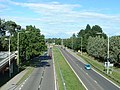
The A338 is a major primary route in southern England, that runs from the junction with the A35 at Poole in Dorset to the junction with the A420 at Besselsleigh...
10 KB (1,073 words) - 23:29, 12 January 2024

Wantage is at the crossing of the B4507 valley road, the A417 road between Streatley and Cirencester, the A338 road between Hungerford (and junction 14 of the...
37 KB (3,639 words) - 23:51, 19 August 2024

Transport in Dorset (redirect from A341 road)
the county. These are: A338, Bournemouth relief road, and through route to Salisbury. A35, from its split from the A31 trunk road, east through Poole, Bournemouth...
10 KB (1,164 words) - 16:26, 16 July 2024

north-east of the city of Salisbury. It is on the A338 road, near its junction with the A303 road. It is in the Test Valley council district but its...
3 KB (187 words) - 21:24, 11 April 2024
the A31 interplexes with the A338; the section of road was widened to four lanes each way for the duration of the A338 interplex (following the upgrade...
20 KB (1,458 words) - 14:43, 2 July 2024

which is the major trunk road in central southern England and provides access to the M27 motorway at Southampton. The A338 road runs northwards from Bournemouth...
86 KB (8,536 words) - 08:48, 13 July 2024

roads in zone 3 in Great Britain starting west of the A3 and south of the A4 (roads beginning with 3). Wikimedia Commons has media related to A roads...
54 KB (56 words) - 23:53, 18 August 2024

further 0.9 miles (1.5 km) upstream, as far as Blackwater Bridge (the A338 road). Boats can be hired from several yards and landings in the harbour and...
16 KB (1,418 words) - 01:21, 19 September 2023

along Centenary Way resulting in a 1.9-mile (3.1 km) concurrency with the A338; much of its former route is now pedestrianised. In May 2021, a sinkhole...
22 KB (1,090 words) - 16:27, 25 July 2024

parish. The A338 road passes through the parish, along the east side of the village. To the north, the A338 links Grove with the A420 road at Besselsleigh...
15 KB (1,519 words) - 17:17, 28 May 2024

The A36 is a trunk road and primary route in southwest England that links the port city of Southampton to the city of Bath. At Bath, the A36 connects with...
12 KB (490 words) - 23:39, 17 January 2024

Bournemouth, south of Downton and Salisbury which are all linked by the A338 road. Fordingbridge is recorded in the Domesday Book of 1086 under the name...
17 KB (1,770 words) - 15:19, 24 December 2023

the A338 road between Fordingbridge and Downton, although the Saxon church and Breamore House are about three-quarters mile (1.2 km) west of the road. Within...
12 KB (1,160 words) - 08:31, 22 June 2024

The A303 is a trunk road in southern England, running between Basingstoke in Hampshire and Honiton in Devon via Stonehenge. Connecting the M3 and the A30...
51 KB (4,615 words) - 17:14, 17 August 2024

Great Western Main Line railway bridge Grove Locks (1) A338 road bridge Grove Locks (5) A417 road bridge Wantage branch Wantage wharf West Challow Bridge...
36 KB (2,889 words) - 19:41, 11 August 2024

northeast of Salisbury. The village is near the River Bourne and the A338 road, and is close to Winterbourne Dauntsey. In 1931 the parish had a population...
8 KB (834 words) - 18:38, 31 August 2023
the village of Boscombe; both villages are on the River Bourne and the A338 road. Most of the west boundary of the parish is also the county boundary with...
11 KB (1,062 words) - 10:20, 16 April 2023

(82 km). From Salisbury the road crosses Cranborne Chase. At Woodyates the road follows the route of Ackling Dyke, a Roman Road for a short distance. The...
6 KB (317 words) - 20:06, 28 February 2023

Kennet on the outskirts of the town at the same time as intersecting with the A338. The route does not enter the town centre, but continues through the northern...
57 KB (4,600 words) - 22:45, 25 October 2023

Dauntsey is a village in Wiltshire, England, in the Bourne valley on the A338 road about 3.5 miles (6 km) northeast of Salisbury. In 1931 the parish had...
6 KB (516 words) - 19:23, 22 March 2024

parish tapers almost to a point, bounded to the west by the A338 road, to the north by the A420 road and to the east by field boundaries. The land is low-lying...
14 KB (1,497 words) - 14:23, 28 May 2024

Gomeldon; all three villages are on the River Bourne and are linked by the A338 road. Porton Down military science park is in the parish, separated from Idmiston...
7 KB (759 words) - 17:01, 24 April 2023
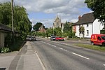
village in Wiltshire, England. The village is in the Bourne valley on the A338 road, about 3.4 miles (5 km) northeast of Salisbury. In 1931 the parish had...
8 KB (729 words) - 19:25, 22 March 2024
road passes the villages on higher ground, on its route towards Old Sarum. The settlements are in the Bourne valley which also carries the A338 road and...
3 KB (246 words) - 14:30, 22 April 2023

in the county of Berkshire, England. The settlement lies near to the A338 road, and is situated approximately 8 miles (13 km) north-west of Newbury....
2 KB (77 words) - 21:57, 22 January 2022
New Forest District. The main geographical features of the area are the A338 road (connecting Poole and Bournemouth with Salisbury) and the Hampshire Avon...
2 KB (166 words) - 18:35, 12 March 2022

The A345 is a secondary A road in Wiltshire, England running from Salisbury to Marlborough and the A4. The road is a main south–north link across Salisbury...
4 KB (443 words) - 12:37, 11 January 2024

The A30 is a major road in England, running 284 miles (457 km) WSW from London to Land's End. The road has been a principal axis in Britain from the 17th...
37 KB (3,881 words) - 16:55, 12 August 2024

The road then follows the Semington bypass, opened in 2004, to Westbury, crossing the A361 between Trowbridge and Devizes. This section of the road has...
17 KB (1,766 words) - 10:00, 9 May 2024

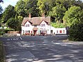
the A338 road. The nearest town is Fordingbridge, which lies approximately 0.5 miles (1 km) to the southwest. Burgate is a hamlet on the A338 road just...
6 KB (654 words) - 00:20, 30 July 2023