
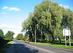
The A529 road is a non-primary road in England that runs from the A41 at Hinstock in Shropshire to the A530 in Nantwich, Cheshire. From 1922 to 1935 it...
943 bytes (50 words) - 18:55, 5 April 2024


swapped with a combination of the A464/A529; from Kingswood Common to Nantwich, Cheshire and the original A529 ran from Hinstock to Chester. North of...
47 KB (2,753 words) - 18:31, 4 August 2024

joins A41 trunk road to form Whitchurch bypass; leaves A41 to continue through Broughall; junction with A530 road; Audlem (crosses A529 road and crosses Shropshire...
5 KB (338 words) - 20:30, 25 February 2024

the north of Audlem, between Lonk Land and Audlem Road, the latter being part of today's A529 road. Cheshire LXVI.NW (includes: Audlem; Buerton; Dodcott...
675 bytes (70 words) - 23:22, 31 January 2023

List of A roads in zone 5 in Great Britain starting north/east of the A5, west of the A6, south of the Solway Firth/Eden Estuary (roads beginning with...
53 KB (46 words) - 09:19, 23 August 2024

Drayton. The A41 road, which until the 1980s ran through its centre, now bypasses the village. Hinstock is at the junction of the A529 road which joins Nantwich...
4 KB (476 words) - 11:38, 28 August 2024
B roads are numbered routes in Great Britain of lesser importance than A roads. See the article Great Britain road numbering scheme for the rationale behind...
81 KB (29 words) - 09:24, 19 August 2024

Market Drayton (section Road)
name. The market is still held every Wednesday. To the south-east near the A529 an 18th-century farmhouse stands on the site of Tyrley Castle, which was...
25 KB (2,519 words) - 10:23, 29 August 2024
Holly House) Late 18th century The milestone is on the west side of the A529 road, and was altered in the early 19th century. It is in red sandstone with...
7 KB (335 words) - 05:06, 20 April 2022

e-weather/parker-county-poolville-texas-severe-storm-debris/287-28dde4f6-a529-4098-b07c-d55775afe682 [bare URL] https://www.weatherforddemocrat...
6 KB (338 words) - 14:43, 26 August 2024
The A530 road is a road linking the A525 east of Whitchurch, Shropshire, England with the A559 east of Northwich, in Cheshire. The road follows the route:...
2 KB (106 words) - 15:07, 8 June 2024
are nearby. The hamlet of Woodseaves is in the east of the parish on the A529. Woodseaves is the midpoint of the longest north–south axis of the UK. Other...
11 KB (1,060 words) - 10:58, 26 August 2024
including Drivers Copse. Three major A roads serve the parish: the A51 (London Road) runs north–south, the A529 (Broad Lane) forms part of the western...
15 KB (1,384 words) - 22:36, 8 July 2024

B5289 is a road in the Lake District, England. It lies in the county of Cumbria, and is an important traffic artery in the Lake District. The road starts...
3 KB (268 words) - 19:17, 17 December 2023

hectares (1,660 acres). The A529 runs north–south through the parish and the B5071 (Crewe Road) runs to the north-east from the A529 junction at Oakes Corner...
17 KB (1,988 words) - 02:23, 16 July 2024

A500, A529, A530 and A534 roads all feed. The stretch of A534 from Nantwich to the Welsh border is seen as one of the ten worst stretches of road in England...
45 KB (4,733 words) - 08:10, 5 September 2024
The A5114 is a British A road which is located on the island of Anglesey, Wales. It runs from a roundabout just off Junction 6 of the A55 (at the intersection...
2 KB (256 words) - 09:24, 21 June 2024
Andy Cadiff Elliot Shoenman & Marley Sims October 17, 1995 (1995-10-17) A529 28.0 While Tim has everyone at the house for Jill's surprise party 40th birthday...
151 KB (3,409 words) - 21:13, 10 August 2024

May 1967. The station site, which was situated to the east on the A529 Adderley Road, near the present site of Morrisons supermarket, is now covered by...
11 KB (993 words) - 20:03, 13 April 2024
Bridgemere Lane/Hunterson Road runs east–west through the parish between the A529 to the west and the A51 to the east. Hunsterson Road runs northwards from...
12 KB (1,018 words) - 17:30, 9 October 2023

and the ceremonial county of Cheshire, England. The village lies on the A529, around 1.25 miles (2.0 km) north east of Audlem and 4.5 miles (7.2 km) south...
20 KB (2,275 words) - 21:29, 8 July 2024
north–south through the parish and is the major road. Brine Pits Lane runs from Coole Lane to Brinepits Farm. The A529 lies to the east of the parish. The South...
11 KB (1,037 words) - 22:21, 14 October 2023