
The Amapá State Forest (Portuguese: Floresta Estadual do Amapá) is a state forest in the state of Amapá, Brazil. The Amapá State Forest is divided between...
4 KB (394 words) - 16:10, 6 April 2021

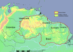
Amapá ([amaˈpa] ) is one of the 26 states of Brazil. It is in the North Region of Brazil. It is the second-least populous state and the eighteenth-largest...
26 KB (2,198 words) - 00:14, 9 August 2024

The Amapá National Forest (Portuguese: Floresta Nacional do Amapá) is a national forest in the state of Amapá, Brazil. It supports sustainable exploitation...
7 KB (652 words) - 13:26, 3 May 2023

Amapá ([ɐmɐˈpa] ) is a municipality located in the easternmost portion of the homonymous state of Amapá in Brazil. Its population is 9,187 and its area...
7 KB (516 words) - 01:07, 19 August 2024

Mazagão (redirect from Mazagão, Amapá, Brazil)
Mazagão, [mazɐˈɡɐ̃w]) is a municipality located in the south of the state of Amapá in Brazil. Its population is 22,053 and its area is 13,131 square kilometres...
8 KB (567 words) - 01:16, 19 August 2024

Oiapoque (category Populated places in Amapá)
(Portuguese pronunciation: [ɔjɐˈpɔki]) is a municipality in the north of the state of Amapá, Brazil. Its population is 27,906 and its area is 22,625 square kilometres...
11 KB (729 words) - 01:12, 19 August 2024

The Araguari River (Portuguese: Rio Araguari) is the primary river of Amapá state in north-eastern Brazil. It became famous among surfers when some decided...
4 KB (260 words) - 18:42, 15 January 2022

Pracuúba (redirect from Cujubim, Amapá)
acres) Amapá State Forest, a sustainable use conservation unit established in 2006. It contains 52.85% of the 460,353 hectares (1,137,560 acres) Amapá National...
6 KB (359 words) - 01:09, 19 August 2024

The flag of Amapá is one of the official symbols of the state of Amapá, Brazil. The current flag was introduced by Decree No. 8 of 23 April 1984. Each...
3 KB (252 words) - 14:38, 11 July 2024
The Rio Amapá Sustainable Development Reserve (Portuguese: Reserva de Desenvolvimento Sustentável do Rio Amapá is a sustainable development reserve in...
8 KB (864 words) - 03:37, 29 February 2024

The Amapá Biodiversity Corridor (Portuguese: Corredor de Biodiversidade do Amapá) is an ecological corridor in the state of Amapá, Brazil. It provides...
6 KB (440 words) - 16:22, 23 March 2024
(1,137,560 acres) Amapá National Forest, a sustainable use conservation unit created in 1989. List of rivers of Amapá FLONA do Amapá (in Portuguese), ISA:...
2 KB (68 words) - 18:42, 15 January 2022

Calçoene (category Populated places in Amapá)
pronunciation: [kawsoˈẽni]) is a municipality located in the east of the state of Amapá in Brazil. It is located on the Atlantic Ocean in the Amazon jungle...
9 KB (667 words) - 01:10, 19 August 2024

Tumucumaque Mountains National Park (category Protected areas of Amapá)
Wayback Machine Corredor de Biodiversidade do Amapá Biodiversity Corridor (PDF), Belém: CI-Brasil, Governo do Amapá, Fundação Lee & Gund, 2007, retrieved 2016-11-05...
11 KB (853 words) - 23:59, 8 August 2024

Porto Grande (redirect from Porto Grande, Amapá, Brazil)
municipality contains 7.72% of the 2,369,400 hectares (5,855,000 acres) Amapá State Forest, a sustainable use conservation unit established in 2006. Porto Grande...
6 KB (339 words) - 01:14, 19 August 2024

Serra do Navio (category Municipalities in Amapá)
matas de Serra do Navio"". Diário do Amapá (in Portuguese). Retrieved 4 April 2021. "Serra do Navio". Government of Amapá (in Portuguese). Retrieved 3 April...
8 KB (439 words) - 01:15, 19 August 2024
Canutama State Forest (Portuguese: Floresta Estadual Canutama) is a state forest in the state of Amazonas, Brazil. The Canutama State Forest is divided...
4 KB (372 words) - 14:40, 8 January 2024

Ferreira Gomes (category Municipalities in Amapá)
Amapá State Forest, a sustainable use conservation unit established in 2006. It also contains 44.07% of the 460,353 hectares (1,137,560 acres) Amapá National...
6 KB (328 words) - 01:13, 19 August 2024
OROV was reported in the northern state of Pará, Brazil, and from 1980 to 2004, OROV had spread to the Amazonas, Amapá, Acre, Rondônia, Tocantins, and Maranhão...
8 KB (992 words) - 22:02, 9 August 2024

The Amapá mangroves (NT1402) is an ecoregion along the Atlantic coast of the state of Amapá in Brazil. The low coastal plain has been formed from recent...
12 KB (1,324 words) - 18:51, 15 February 2024

Falsino River (category Rivers of Amapá)
(1,137,560 acres) Amapá National Forest, a sustainable use conservation unit created in 1989. List of rivers of Amapá FLONA do Amapá (in Portuguese), ISA:...
2 KB (75 words) - 18:42, 15 January 2022
qualified for PRONAF support. The state-level conservation units in the BR-319 corridor are the Piagaçu-Purus, Rio Amapá, Rio Madeira, Igapó-Açu and Matupiri...
4 KB (357 words) - 14:51, 8 January 2024

Rio Curiaú Environmental Protection Area (category Protected areas of Amapá)
protection area in the state of Amapá, Brazil. It attempts to protect the environment of a region of forest and flooded fields close to the state capital, Macapá...
8 KB (919 words) - 18:10, 16 July 2023

the state is home to 30% of the entire country's Atlantic Forest, with emphasis on the Alto Ribeira Tourist State Park (PETAR), Serra do Mar State Park...
182 KB (17,492 words) - 21:40, 20 August 2024

Retrieved 2 February 2017. Queiroz, Diego (18 March 2016). "SUFRAMA assists Amapá State to disclose opportunities" (in Portuguese). SUFRAMA. Archived from the...
62 KB (6,476 words) - 13:50, 20 June 2024

Pedra Branca do Amapari (category Municipalities in Amapá)
1997. It contains 6.39% of the 2,369,400 hectares (5,855,000 acres) Amapá State Forest, a sustainable use conservation unit established in 2006. The municipality...
7 KB (454 words) - 01:14, 19 August 2024

Tartarugalzinho (category Municipalities in Amapá)
hectares (5,855,000 acres) Amapá State Forest, a sustainable use conservation unit established in 2006. List of municipalities in Amapá IBGE 2020 "Tartarugalzinho"...
6 KB (328 words) - 01:09, 19 August 2024
Guiana Shield (category Geography of Amapá)
French Guiana and the Tumucumaque National Park in the Amapá State of Brazil. In Venezuela the forests are protected by Canaima, Parima-Tapirapeco and Serranía...
14 KB (1,308 words) - 23:34, 26 July 2024
Rio Iratapuru Sustainable Development Reserve (category Protected areas of Amapá)
sustainable development reserve in the state of Amapá, Brazil. It contains a well-preserved area of terra firme forest with rich fauna. The local communities...
11 KB (1,177 words) - 22:08, 14 July 2023

National System of Nature Conservation Units, a national forest of Brazil is an area with forest cover of predominantly native species that has as its basic...
10 KB (78 words) - 20:08, 10 March 2024