
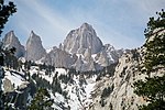
The Amargosa Range is a mountain range in Inyo County, California and Nye County, Nevada. The 110-mile (180 km) range runs along most of the eastern side...
2 KB (200 words) - 23:33, 2 April 2024

The Amargosa River is an intermittent waterway, 185 miles (298 km) long, in southern Nevada and eastern California in the United States. The Amargosa River...
21 KB (2,021 words) - 15:17, 21 August 2024

California, where the Amargosa River enters into the Amargosa Canyon. The Amargosa Valley ("the Valley") is located within the Basin and Range Province ("the...
16 KB (2,036 words) - 20:21, 12 April 2024
Alabama Hills Alexander Hills Alvord Mountain Amargosa Range Amedee Mountains Antelope Hills Argus Range Arica Mountains Avawatz Mountains Bacon Hills...
13 KB (1,132 words) - 02:10, 30 January 2024

Reserve. It runs from north to south between the Amargosa Range on the east and the Panamint Range on the west. The Grapevine Mountains and the Owlshead...
44 KB (4,021 words) - 12:41, 22 August 2024
116.81111°W / 36.42000; -116.81111 Zabriskie Point is a part of the Amargosa Range located east of Death Valley in Death Valley National Park in California...
7 KB (774 words) - 03:11, 21 July 2024

Funeral Mountains (category Amargosa Desert)
subrange of the Amargosa Range that form the eastern wall of Death Valley. The crest of the range is within Death Valley National Park. The range is separated...
4 KB (243 words) - 07:36, 26 November 2023

Aleutian Range, Alaska Chigmit Mountains, Alaska Neacola Mountains, Alaska Amargosa Range, California Appalachian Mountains, Eastern United States Appalachian...
51 KB (4,774 words) - 13:49, 4 August 2024
Amargosa is the Spanish name of the plant Centaurium erythraea. It may also refer to: Amargosa toad Amargosa vole Amargosa Desert Amargosa Range Amargosa...
779 bytes (110 words) - 15:19, 24 February 2022

5 square miles (82 km2), over 99% of it being land. Springs in the Amargosa Range created a natural oasis at Furnace Creek, which has subsequently dwindled...
22 KB (1,665 words) - 17:02, 20 August 2024
isolated California peak. Telescope Peak is the highest summit of the Panamint Range. San Jacinto Peak is the highest summit of the San Jacinto Mountains. Mount...
54 KB (5,512 words) - 00:21, 24 February 2024

Devils Hole (category Amargosa Desert)
pool within a limestone cavern in the Amargosa Desert in the Amargosa Valley of Nevada, east over the Amargosa Range and Funeral Mountains from Death Valley...
16 KB (1,939 words) - 23:24, 2 August 2024

"Dante's View". Dante's View is part of the Black Mountains, a part of Amargosa Range, that was geological Mesozoic volcanoes. These mountains were created...
6 KB (688 words) - 13:02, 20 August 2024

the Nopah Range and southeast of the Amargosa Range and Greenwater Range. The mountains in Inyo County, California, lie between the Amargosa River and...
3 KB (218 words) - 00:23, 1 November 2021

of Slate Ridge lie to the northwest and the northernmost spur of the Amargosa Range, the Grapevine Mountains, is just to the south of the townsite. Bonnie...
5 KB (301 words) - 23:36, 20 August 2023

Mountain Range is a short range, about 9 miles (14 km) long, trending northwest by southeast. The north end of the range borders Beatty on the Amargosa River...
3 KB (229 words) - 15:42, 29 July 2024

Junction, home of the Amargosa Opera House and Hotel, and the Amargosa River are to the east of the Greenwater Range. "Greenwater Range". Geographic Names...
2 KB (142 words) - 19:23, 1 July 2021

Policy and Management Act of 1976. Tecopa is on the east side of the Amargosa Range which lies between the CDP and Death Valley, which was designated a...
29 KB (2,982 words) - 09:18, 30 June 2024

Mojave Desert (redirect from Mojave Basin and Range (ecoregion))
mountains and disappears underground in the Mojave Desert. The other is the Amargosa River, which flows partly underground through the Mojave Desert along a...
49 KB (3,585 words) - 07:11, 3 August 2024

Valley to the west, and Yucca Mountain and the Nellis Air Force Range to the east. The Amargosa Desert is an arid desert habitat and an ecotone between the...
11 KB (1,122 words) - 06:54, 25 August 2022

processed here from the Golden Treasure Mine 5 miles to the east in the Amargosa Range, and processed for further smelting. List of ghost towns in California...
3 KB (144 words) - 14:39, 21 May 2024
north of Furnace Creek, California west to Funeral Mountains and Amargosa Range, Amargosa Valley around Beatty, Nevada as well northwest to Grapevine Mountains;...
32 KB (3,706 words) - 22:29, 25 February 2024

Black Mountains (California) (category Amargosa Desert)
Death Valley National Park. The Black Mountains are a southern range of the Amargosa Range System and lie in a generally north–south direction at their...
3 KB (282 words) - 20:41, 24 December 2023

borax mining in Death Valley and at the 20 Mule Team Canyon mine in the Amargosa Range to the east. In 1890, upon William Tell Coleman's Harmony Borax Works...
22 KB (2,459 words) - 22:50, 28 April 2024

Rhyolite, Nevada (category Amargosa Desert)
Beatty and the Amargosa River. To the west, roughly 5 miles (8.0 km) from Rhyolite, the Funeral and Grapevine Mountains of the Amargosa Range rise between...
39 KB (4,016 words) - 10:14, 15 August 2024
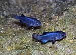
Devils Hole pupfish (category Amargosa Desert)
the Amargosa Desert ecosystem, in the Amargosa Valley, of southwestern Nevada, US, east of Death Valley and the Funeral Mountains and Amargosa Range. The...
64 KB (7,236 words) - 18:08, 10 July 2024

Places of interest in the Death Valley area (redirect from Amargosa Chaos)
to the southeast; and Mount Charleston in Nevada far to the east. The Amargosa Chaos is a series of geological formations located in the Black Mountains...
32 KB (4,096 words) - 08:28, 24 July 2024

Bullfrog, Nevada (category Amargosa Desert)
from Bullfrog, the Funeral and Grapevine Mountains of the Amargosa Range rise between the Amargosa Desert in Nevada and Death Valley in California. Bullfrog...
6 KB (366 words) - 19:16, 19 July 2024

Location Death Valley National Park, Inyo County, California, U.S. Parent range Amargosa Range Climbing Easiest route Trail from Daylight Pass Road (hike)...
3 KB (142 words) - 23:35, 2 April 2024

town, Ryan is situated at an elevation of 3,045 feet (928 m) in the Amargosa Range, 8 miles (13 km) northeast of Dante's View and 15 miles (24 km) southeast...
8 KB (729 words) - 22:11, 15 June 2024