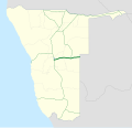
B6 is a national highway of eastern-central Namibia. It is 318 kilometres (198 mi) long and connects the capital Windhoek with the Buitepos border crossing...
3 KB (227 words) - 22:20, 17 September 2022

national highway in Namibia. The 76 kilometres (47 mi) stretch of road between Windhoek and Okahandja is the only A-rated road in Namibia. Consisting of freeway...
6 KB (646 words) - 21:36, 28 May 2024
become independent of the Cape Colony. Namibia's road network is regarded as one of the best on the continent; road construction and maintenance adheres...
12 KB (974 words) - 13:20, 4 June 2024
route in Namibia that runs from Leonardville to the B6 near Hosea Kutako International Airport via Dordabis. Google (3 July 2020). "C23 road (Namibia)" (Map)...
1 KB (39 words) - 23:37, 2 July 2020
C29 is a secondary route in Namibia that runs from the south, at the B6 junction approximately 65 miles east of Windhoek. The C29 then terminates to the...
1 KB (49 words) - 06:49, 24 September 2022
C22 is a secondary route in Namibia that exists in two discontinuous sections: a southern section running from Aranos to Gobabis, and a northern section...
2 KB (80 words) - 21:02, 2 July 2020

The B14 is a national road in Namibia, running since 2018 from Gobabis to Grootfontein. A further expansion from Gobabis to Aranos in the south is planned...
1 KB (63 words) - 06:48, 24 September 2022

The A2 begins at the Buitepos border with Namibia, where it is designated as the B6 road on the Namibian side towards Gobabis and Windhoek. It begins...
4 KB (326 words) - 07:33, 10 July 2024

The B1 is a national highway of Namibia, and is the country's longest and most significant road, running the length of the country from south to north...
8 KB (825 words) - 23:25, 5 November 2022

B4 is a national highway of Namibia. It passes through the ǁKaras Region of Namibia in the south-west in a west–east direction for 334 kilometres (208 mi)...
2 KB (106 words) - 23:03, 11 May 2023

Buitepos (category Botswana–Namibia border crossings)
in eastern Namibia. It is situated on the national road B6 which is part of the Trans-Kalahari Highway, and a border post between Namibia and Botswana...
4 KB (95 words) - 03:43, 12 April 2024
highway in southern Namibia. It starts north of Mariental and ends in Gobabis. The highway is 320 kilometres (200 mi) long. The road travels eastwards past...
1 KB (61 words) - 09:43, 11 July 2023
Trans-Kalahari Corridor (category Roads in Namibia)
of Windhoek (capital of Namibia) where it reaches a junction with the B6 road. At this junction, the corridor becomes the B6 eastwards. The section from...
5 KB (546 words) - 12:06, 15 March 2024

Hosea Kutako International Airport (category Airports in Namibia)
international airport of Namibia, serving the capital city Windhoek. Located well east of the city, 45 km (28 mi), it is Namibia's largest airport with international...
28 KB (2,193 words) - 15:53, 18 August 2024

B8 road often known as the Golden Highway is one of the national highways of Namibia. It leads from the B1 at Otavi via Grootfontein and Rundu through...
3 KB (158 words) - 10:21, 21 September 2023
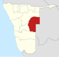
Omaheke Region (category Regions of Namibia)
business area, as it is linked with the capital of Namibia, Windhoek, by rail and the tarred B6 national road. This infrastructure serves as the main supply...
14 KB (1,053 words) - 12:37, 24 July 2024

The University of Namibia (UNAM) is a multi-campus public research university in Namibia, and the largest university in the country. It was established...
12 KB (1,055 words) - 12:51, 12 August 2024

road from the right B6: Give Way sign, must give priority to other traffic on the main road ahead B7: Stop: Give priority to traffic on the main road...
24 KB (1,801 words) - 20:08, 15 May 2024
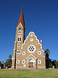
Christ Church, Windhoek (category Art Nouveau church buildings in Namibia)
landmark and Lutheran church in Windhoek, Namibia, belonging to the German-speaking Evangelical Lutheran Church in Namibia. It was designed by architect Gottlieb...
5 KB (433 words) - 15:11, 12 September 2023
Parliament Building, Windhoek (category Parliament of Namibia)
both houses of the Parliament of Namibia (the National Council and the National Assembly). It is located in the Namibian capital of Windhoek. The Tintenpalast...
7 KB (368 words) - 15:38, 16 November 2023
Transport in Tanzania (redirect from Roads in Tanzania)
Transport in Tanzania includes road, rail, air and maritime networks. The road network is 86,472 kilometres (53,731 mi) long, of which 12,786 kilometres...
22 KB (2,260 words) - 02:44, 12 July 2024

Seeis (category Farms in Namibia)
central Namibia. It is situated on the B6 national road 11 km (6.8 mi) east of Hosea Kutako International Airport on the turnoff of the dirt road D1458...
9 KB (545 words) - 22:15, 12 April 2024

Zhengzhou (section Roads and expressways)
commenced in 2009. The system consists of 5 main routes (B1, B2, B3, B5 and B6) with dedicated bus lanes and dozens of branch routes that serve most areas...
80 KB (6,940 words) - 17:52, 18 August 2024
Southern African Development Community Regional Trunk Road Network or SADC RTRN is a trans nation road network across Southern Africa. The projects in Africa...
12 KB (483 words) - 04:01, 8 July 2024

motorways. The remaining 11,747 kilometres (7,299 mi) worth of roads are unpaved. Road distances are shown in kilometers and Botswana speed limits are...
9 KB (625 words) - 11:12, 11 August 2024

Transport in Botswana (section Road transport)
two longest bridges. Namibia by Trans-Kalahari Corridor. South Africa by A1 highway (Botswana), A2 highway (Botswana), A11 road (Botswana) and A12 highway...
18 KB (1,531 words) - 06:38, 9 June 2024

Parliament Gardens (category Parks in Namibia)
Gardens is a small park in downtown Windhoek, Namibia. It is located between the Tintenpalast (Namibia's Parliament building) and the Christuskirche. It...
5 KB (375 words) - 02:55, 22 May 2024

Staggered junction ahead B4: Staggered junction ahead B5: T-junction ahead B6: Y-junction ahead B7: Traffic merges from left B8: Traffic merges from right...
8 KB (605 words) - 06:51, 27 June 2024
Timeline of Windhoek (category Years in Namibia)
The following is a timeline of the history of the city of Windhoek, Namibia. 1840s - Nama Orlam chief Jonker Afrikaner names settlement "Winterhoek" 1880...
17 KB (1,323 words) - 11:01, 22 July 2024
Windhoek College of Education (category Namibian building and structure stubs)
Education (now known as the University of Namibia Khomasdal campus) is a public university in Khomasdal, Windhoek, Namibia. It opened in 1978 and is one of four...
1 KB (98 words) - 02:03, 1 September 2023