
The Baron of Mauá International Bridge (Portuguese: Ponte Internacional Barão de Mauá, Spanish: Puente Internacional Barón de Mauá) is a bridge that crosses...
2 KB (133 words) - 00:21, 18 August 2024

Río Branco, Uruguay (redirect from History of Río Branco, Uruguay)
department of northeastern Uruguay, it borders the Brazilian city of Jaguarão, with which it communicates through the Baron of Mauá International Bridge. The...
5 KB (318 words) - 16:41, 17 August 2023

Transport The district of Visconde de Mauá is named after him The Baron of Mauá International Bridge links the city of Jaguarão, Rio Grande do Sul with Río...
8 KB (847 words) - 09:35, 9 August 2024
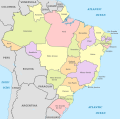
borders of Brazil are the international borders that Brazil shares with neighbouring countries. Brazil has terrestrial boundaries with nine countries of South...
10 KB (451 words) - 01:42, 24 August 2024

Melo, Uruguay (section Places of worship)
Near Melo is situated the old Posta del Chuy, a stone inn near an ancient bridge over the Chuy del Tacuarí creek. Melo was visited by Pope John Paul II in...
13 KB (810 words) - 03:37, 15 August 2024
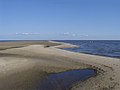
Lago Merín is a village and resort on the coast of Lagoon Merín, in the Cerro Largo Department of Uruguay. Although it has a very few permanent inhabitants...
3 KB (158 words) - 05:38, 2 February 2023

site of the Battle of Jaguarão, fought against Uruguayan forces. Located in the extreme south of Brazil and the border with Uruguay, the Baron of Mauá International...
4 KB (141 words) - 07:10, 9 August 2024

centre in the Cerro Largo Department of eastern Uruguay. It is located on the north bank of Río Tacuarí, near the bridge Paso del Dragóneast, over which Route...
3 KB (112 words) - 05:38, 2 February 2023

is unique in South America. It has been declared a site of National Heritage. The history of its construction is described in "Los árboles de piedra"...
1 KB (142 words) - 19:26, 25 May 2019
Uruguay. It is the head of the Municipality of Quebracho. Quebracho is located in the center-west part of the department of Cerro Largo, on the Tupambaé...
3 KB (122 words) - 01:40, 9 September 2023
of the Municipality of Tres Islas. Tres Islas is located in the western part of the department of Cerro Largo, on the hill of the same name, north of...
3 KB (162 words) - 05:39, 2 February 2023
(29 mi) west of the department capital city of Melo. It lies north of Fraile Muerto and Tres Islas. In 2011 Ramón Trigo had a population of 150. Source:...
3 KB (145 words) - 05:05, 10 December 2023
suburb of the city of Melo in the Cerro Largo Department of eastern Uruguay. It is located on Ruta 26, about 1.5 kilometres (0.93 mi) west of the barrio...
3 KB (132 words) - 05:36, 2 February 2023
district) of Melo, the capital of Cerro Largo Department of eastern Uruguay. It derives its name from the Hipódromo de Melo, the horse racing track of the city...
3 KB (136 words) - 05:58, 2 February 2023
Department of eastern Uruguay. It is located on Route 8, 12 kilometres (7.5 mi) south of Aceguá on the border with Brazil and 45 kilometres (28 mi) north of the...
4 KB (192 words) - 05:34, 2 February 2023

municipality of Río Branco is one of the municipalities of Cerro Largo Department, Uruguay, established on 13 September 2009. Its seat is the town of Río Branco...
11 KB (787 words) - 09:41, 4 January 2024
Brazil passes through the town and the two parts are separated by an international street. Its status was raised from populated centre to "Pueblo" (village)...
4 KB (188 words) - 05:35, 2 February 2023
Cerro Largo Department (category Departments of Uruguay)
could rest and pay the fares for using the first public work of the Republic, the stone bridge over the stream Chuy del Tacuarí, today a Heritage Monument...
10 KB (632 words) - 03:38, 15 August 2024

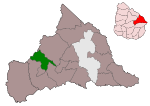
municipality of Quebracho is one of the municipalities of Cerro Largo Department, Uruguay, established on 30 October 2018. Its seat is the settlement of Quebracho...
5 KB (265 words) - 21:10, 24 March 2024
Fraile Muerto (section Places of worship)
Largo Department of eastern Uruguay. Its name means "Dead Friar". It is located on Route 7, around 38 kilometres (24 mi) west-southwest of Melo. It was founded...
4 KB (198 words) - 22:40, 10 May 2024
Tupambaé (section Places of worship)
Department of eastern Uruguay. It is located on the border with Treinta y Tres Department, on Km. 334 of Route 7, about 86 kilometres (53 mi) southwest of Melo...
3 KB (155 words) - 05:35, 2 February 2023
municipality of Tres Islas is one of the municipalities of Cerro Largo Department, Uruguay, established on 30 October 2018. Its seat is the town of Tres Islas...
4 KB (180 words) - 16:29, 31 August 2021

municipality of Ramón Trigo is one of the municipalities of Cerro Largo Department, Uruguay, established on 3 April 2013. Its seat is the town of Ramón Trigo...
8 KB (571 words) - 13:20, 24 April 2024

Jaguarão River (category International rivers of South America)
town of Jaguarão. Regarding its navigability, vessels sailing on the nearby Mirim Lagoon are by treaty under Brazilian jurisdiction. Geography of Uruguay#Topography...
2 KB (160 words) - 18:45, 5 September 2024

São Paulo (redirect from São Paulo International Transport Industry Show)
Antônio da Silva Prado, Baron of Duprat and Washington Luís, who governed from 1899 to 1919, contributed to the climate development of the city; some scholars...
250 KB (21,177 words) - 22:21, 17 September 2024

Occurrence Number 13/1524 - Beechcraft Baron G58 - N254F - Departure From Controlled Flight- 31 Km South-West Of Raglan - Tasman Sea - 30 March 2013 (PDF)...
161 KB (2,603 words) - 17:13, 14 September 2024

After being acquired by the Baron of Mauá, one of the pioneers of industrialization in Brazil, it was renamed Chácara Mauá. In 1878, the land was bought...
13 KB (1,385 words) - 21:28, 27 July 2024

Rio Grande do Sul (redirect from State of Rio Grande do Sul)
Salgado Filho International Airport can receive 28 large airplanes simultaneously. The terminal has 32 check-in counters, ten boarding bridges, nine elevators...
111 KB (11,967 words) - 20:30, 17 September 2024

Grande Seca (category Climate of Brazil)
1854, connecting the Port of Mauá to Raiz da Serra in the province of Rio de Janeiro. By 1900, Brazil had some 20,000 km of track. As shown in Figure...
56 KB (7,830 words) - 08:41, 7 April 2024