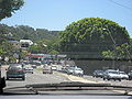
Barrenjoey Road is a main urban road along the northern coast of the Northern Beaches suburbs of Sydney, Australia. In 1978, the Barrenjoey Road area came...
10 KB (825 words) - 06:03, 13 August 2024

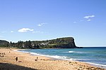
Northern Beaches Council. Palm Beach sits on a peninsula at the end of Barrenjoey Road near Pittwater and is the northernmost beach in the Greater Sydney...
20 KB (2,192 words) - 04:58, 27 June 2024
Investment Bank Barrenjoey Road, a road through the Northern Beaches, Sydney, New South Wales Barrenjoey Head Lighthouse, a lighthouse on Barrenjoey headland...
465 bytes (92 words) - 16:04, 13 July 2023
early before hitchhiking home, at which point she entered a vehicle on Barrenjoey Road and has not been seen since. Her disappearance sparked New South Wales'...
10 KB (911 words) - 13:42, 3 February 2024
intersecting with Barrenjoey Road in Mona Vale, where it widens to a four-lane, dual-carriageway road, and meets Mona Vale Road shortly afterwards (with...
12 KB (1,033 words) - 05:57, 13 August 2024

Anglican 14.3%. The main road connecting the northern part of the Barrenjoey Peninsula to the rest of Sydney, Barrenjoey Road, runs through Hewitt Park...
6 KB (596 words) - 16:16, 4 August 2024

Ocean to the east and Pittwater to the west. A major road along the peninsula is Barrenjoey Road. Its ocean beach is patrolled by Newport Surf Life Saving...
5 KB (480 words) - 04:55, 27 June 2024

Wolseley Road is a road in the Sydney suburb of Point Piper. It is one kilometre long. It starts at New South Head Road and curves around the west side...
6 KB (471 words) - 21:44, 27 September 2023

Yarratt Whian Whian Ballambur Street Ballandella Road Barrenjoey Road Belconnen Way Bindubi Street Bunnerong Road Canberra Avenue Coranderrk Street Ginninderra...
56 KB (1,989 words) - 06:17, 5 June 2024
feature. Barrenjoey High School Avalon Public School Maria Regina Catholic Primary School Montessori public school on the former grounds of Barrenjoey Highschool...
13 KB (1,465 words) - 11:43, 3 August 2024

329796°E / -33.580147; 151.329796 The Barrenjoey Head Lighthouse is a heritage-listed lighthouse at Barrenjoey Headland in the Sydney suburb of Palm Beach...
34 KB (4,586 words) - 12:11, 25 May 2024
William Street York Street Suburban roads Anzac Parade Appian Way Bangor Bypass Barrenjoey Road Blacktown Road Bondi Road Burnt Bridge Creek Deviation City...
3 KB (216 words) - 04:12, 22 August 2024
History The Barracks How do you repair one of Sydney’s busiest, oldest roads? In the dark of night, with 120,000 glass jars Sydney Morning Herald 13...
2 KB (167 words) - 05:27, 29 August 2024
the Princes Highway officially and is allocated route A36. Like Parramatta Road, King Street is believed to follow the line of ancient Aboriginal track that...
9 KB (790 words) - 03:00, 16 January 2024

William Street York Street Suburban roads Anzac Parade Appian Way Bangor Bypass Barrenjoey Road Blacktown Road Bondi Road Burnt Bridge Creek Deviation City...
3 KB (192 words) - 23:17, 7 April 2023
business district to Windmill Street in Millers Point. Originally a two way road throughout, in connection with the opening of the Western Distributor, on...
2 KB (114 words) - 03:42, 31 March 2024

efficient grid system of connecting roads with primary access from Ocean Beach Road, West Street and Barrenjoey Road. Umina Oval, located at the southern...
12 KB (1,327 words) - 01:11, 9 August 2024
Alfred Street, Sydney (category Infobox Australian road articles with an infobox mapframe map)
In February 1999, Alfred Street was closed outside Customs House with the road converted to a plaza. Until the line closed in 1957, trams terminated in...
3 KB (276 words) - 02:35, 27 March 2024
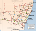
Road routes in New South Wales assist drivers navigating roads throughout the state, as roads may change names several times between destinations, or...
119 KB (2,044 words) - 00:25, 3 July 2024

A8 (Sydney) (category Pages using infobox Australian road with a mapframe parameter)
declaration as part of Main Road 164. The route was signed State Route 14 across its entire length (and continuing north along Barrenjoey Road to Palm Beach) in...
15 KB (1,340 words) - 03:54, 29 April 2024

On 29 August 1969, a security guard Joseph Charles Coffman, 39, of Barrenjoey Road, Newport, was shot and killed by an unknown assailant. It appeared...
16 KB (1,659 words) - 06:29, 21 August 2024
Beach Governor Phillip Park, Barrenjoey Road Fourth Sunday of each month, 9 am – 3 pm Parklea Markets Parklea Sunnyholt Road Every day Penrith Showground...
18 KB (190 words) - 07:48, 7 May 2024
landscape." Muller died on 17 February 2023, at the age of 95. 949 Barrenjoey Road, Palm Beach, Sydney, Australia, 1956 Like many of Peter Muller’s designs...
15 KB (1,804 words) - 13:43, 3 November 2023

City West Link (redirect from City West Link Road)
City West Link is a 5.0-kilometre (3.1 mi) link road connecting Parramatta Road and the Western Distributor through the Inner West suburbs of Sydney,...
16 KB (1,403 words) - 05:25, 29 August 2024

Wakehurst Public School Wheeler Heights Public School Yanginanook School High Barrenjoey High School Balgowlah Boys High School Cromer Campus Davidson High School...
17 KB (1,369 words) - 13:57, 3 August 2024
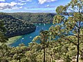
the Hawkesbury River, west of Pittwater and north of Mona Vale Road. It includes Barrenjoey Headland on the eastern side of Pittwater. Ku-ring-gai Chase...
23 KB (2,440 words) - 04:11, 12 May 2024
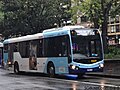
sharp curves at Bilgola, known as the Bilgola Bends. In April 1986 Barrenjoey Road was widened allowing Mercedes-Benz O305 articulated buses to replace...
11 KB (1,064 words) - 11:12, 24 July 2024
Church Presbytery Surrey Hotel Sky News Australia CBD Studio Australian Roads portal Gregory's 2002 Street Directory, 66th Edition, Maps 345,375 Anzac...
12 KB (1,019 words) - 00:53, 21 March 2024
James Ruse Drive (category WikiProject Australian Roads articles with a junction list using templates)
the interchange with Windsor Road in Northmead; the road continues west as Briens Road, part of Cumberland Highway. The road was named in honour of James...
19 KB (1,454 words) - 21:03, 11 September 2023

Hunter Street, Sydney (category Infobox Australian road articles with an infobox mapframe map)
William Street York Street Suburban roads Anzac Parade Appian Way Bangor Bypass Barrenjoey Road Blacktown Road Bondi Road Burnt Bridge Creek Deviation City...
4 KB (366 words) - 00:09, 8 March 2024