
(0.33–0.66 ft/s). Labūnava Reservoir dams the Barupė river; smaller ponds are also located in the Barupė valley in Kuigaliai and Labūnava. Sangailiškiai...
3 KB (275 words) - 05:15, 9 March 2024

left bank of the Nevėžis river, by its tributary the Barupė. The Labūnava Reservoir on the Barupė is located next to the village. Labūnava has a kindergarten...
4 KB (240 words) - 16:18, 16 August 2024

kilometres and has a basin area of 93 km². It is a left tributary of the Barupė. The Mėkla river starts nearby Preišiogala, in Jonava District Municipality...
3 KB (160 words) - 09:35, 29 December 2020

Juoda, Upytė, Linkava, Brasta, Žalesys, Alkupis, Obelis, Šerkšnys, Ašarėna, Barupė, Gynia; right: Juosta, Kiršinas, Liaudė, Kruostas, Dotnuvėlė, Smilga, Šušvė...
9 KB (846 words) - 15:53, 5 July 2024

area of 77 square kilometres (30 sq mi). It is a left tributary of the Barupė. The Urka river starts in the Bitvanas Forest, in Kaunas District Municipality...
3 KB (197 words) - 03:33, 5 January 2021
located 5 kilometres (3.1 mi) from Labūnava, by the Barupė river and the Pašiliai Forest. The Barupė Hydrographical Sanctuary is located nearby. In the...
3 KB (97 words) - 17:25, 13 January 2021

40 people. It is located 2.5 kilometres (1.6 mi) from Labūnava, by the Barupė river (the Labūnava Reservoir). There is a grain elevator. In the beginning...
3 KB (101 words) - 09:04, 11 August 2024

of 80 people. It is located 2 kilometres (1.2 mi) from Nociūnai, by the Barupė river, between the roads "Jonava-Šeduva" (KK144) and A8. There is a cemetery...
4 KB (199 words) - 09:22, 14 May 2022

Rivers: Nevėžis, Barupė, Urka, Mėkla, Lankesa, Ašarėna Lakes and ponds: Labūnava Reservoir. Forests: Labūnava Forest. Protected areas: Barupė Hydrographical...
4 KB (212 words) - 13:11, 29 November 2023

census, the village has a population of 409 people. Village established on Barupė river. "2011 census". Statistikos Departamentas (Lithuania). Retrieved July...
2 KB (44 words) - 06:43, 25 July 2024
Kėdainiai, next to Labūnava village. It was created in 1977, when a dam on the Barupė river was built next to Labūnava village. In 2003, the dam was reconstructed...
3 KB (139 words) - 04:01, 9 March 2024

Kruopiai Forest, the Servydgalis Forest. Most of the forest belongs to the Barupė basin. As of the 1980s, 31 % of the area was covered by birch, 30 % by spruce...
3 KB (155 words) - 04:08, 9 March 2024
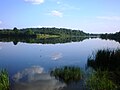
by the Labūnava Reservoir (on the former confluence of the Mėkla and the Barupė). Pamėkliai and the Labūnava Reservoir Pamėkliai and the Labūnava Reservoir...
3 KB (104 words) - 20:51, 13 January 2021

Išorai – 437 Jonava District Municipality is divided into 9 elderships: Barupės pagrindinė mokykla Batėgalos pagrindinė mokykla Bukonių pagrindinė mokykla...
7 KB (196 words) - 20:27, 11 March 2024

304 residents. It is located 9 kilometres (5.6 mi) from Kėdainiai, by the Barupė river, next to the crossroad of the Jonava-Šeduva (KK144) road and A8 highway...
4 KB (162 words) - 17:23, 20 December 2023

settlement within eldership was Kulva. Rivers: Juodmena, Neris, Šlėna, Barupė, Lankesa; Protected areas: Kulva Geomorphological Sanctuary; Eskers: Kulva...
5 KB (129 words) - 18:20, 5 July 2023