Blanice may refer to places in the Czech Republic: Blanice (Otava), a river in the South Bohemian Region, tributary of the Otava Blanice (Sázava), a river...
314 bytes (81 words) - 12:57, 20 November 2023

The Blanice (German: Blanitz) is a river in the Czech Republic, a right tributary of the Otava River. It flows through the South Bohemian Region. It is...
7 KB (695 words) - 10:05, 22 August 2024

The Blanice (German: Blanitz) is a river in the Czech Republic, a left tributary of the Sázava River. It flows through the South Bohemian and Central...
6 KB (467 words) - 10:02, 22 August 2024

Republic. It has about 1,800 inhabitants. It lies near the Sázava and Blanice rivers. The villages of Dalovy, Křešice, Lbosín, Měchnov, Radonice, Šternov...
10 KB (843 words) - 06:43, 6 June 2024

Saint Wenceslas Rises from the Mountain at the Head of the Knights of Blanice (1898)...
2 KB (154 words) - 15:45, 31 May 2023

(in Stříbro) Kosový potok Hamerský potok Sázava (in Davle) Blanice (a.k.a. Vlašimská Blanice) Želivka Trnava (a.k.a. Trnávka) Sázavka Šlapanka Kocába Mastník...
28 KB (1,828 words) - 18:42, 22 August 2024

Tributary Length (km) River km Side Želivka 103.9 98.8 left Blanice 66.0 78.6 left Šlapanka 39.0 164.4 left Konopišťský potok 33.0 31.3 left Sázavka 32...
7 KB (661 words) - 10:02, 22 August 2024

above sea level. The Blanice River flows through the town. South of the town proper is the Husinec Reservoir, built on the Blanice. It was built in 1935–1939...
9 KB (756 words) - 13:36, 22 August 2024

Republic. It has about 2,700 inhabitants. The villages of Bendovo Záhoří, Blanice, Chocov, Dolní Kouty, Dubina, Horní Kouty, Janov, Krchova Lomná, Noskov...
12 KB (1,212 words) - 09:50, 22 July 2024

preserved and is protected by law as an urban monument zone. The villages of Blanice, Čichtice, Svinětice, Tourov and Útěšov are administrative parts of Bavorov...
8 KB (596 words) - 13:48, 2 June 2024

The northwestern part is drained by the Otava River and its tributary Blanice. The České Budějovice Basin is known for large amount of fish ponds, which...
5 KB (488 words) - 09:24, 24 February 2023

Groß Bistrzitz: Valašská Bystřice Groß Bittesch: Velká Bíteš Großblanitz: Blanice, p. of Bavorov Groß Blatnitz (Groß Blattnitz): Blatnice pod Svatým Antonínkem...
261 KB (29,422 words) - 03:19, 14 July 2024

to supply gypsum stone from Salzkammer in Lower Austria. In 1847, the Blanice river was made navigable by Lanna's firm and the Stádlec Suspension Bridge...
20 KB (2,750 words) - 00:45, 3 July 2024

above sea level. The stream of Živný potok flows through the town. The Blanice River flows along the northwestern municipal border. Prachatice was founded...
13 KB (1,209 words) - 05:25, 7 August 2024

Tributary Length (km) River km Side Blanice 94.7 32.8 right Lomnice 59.3 24.9 left Volyňka 46.1 54.6 right Ostružná 41.3 88.9 left Křemelná 30.3 111.7...
6 KB (588 words) - 11:10, 22 August 2024

Uplands. The highest point is at 528 m (1,732 ft) above sea level. The Blanice River flows through the town. The castle is Vlašim was probably built in...
8 KB (576 words) - 12:20, 19 May 2024

other notable rivers that originates in the territory are the Jihlava and Blanice. The most populous towns in the territory are Jindřichův Hradec, Pelhřimov...
5 KB (492 words) - 04:07, 10 May 2024

level. Český Šternberk is situated at a bend of the Sázava River. The Blanice forms the southern municipal border and flows into the Sázava. Český Šternberk...
6 KB (363 words) - 09:12, 7 June 2024

of Protivín, a nameless hill at 555 m (1,821 ft) above sea level. The Blanice River flows through the town. There are several fishponds in the municipal...
7 KB (534 words) - 11:55, 12 July 2024

Papillon-poitou-charentes Jan Šumpich Butterflies and moths (Lepidoptera) of the Blanice National Nature Monument (Bohemian Forest, Czech Republic) Fauna Europaea...
2 KB (134 words) - 23:19, 12 December 2023

above sea level. The municipality is situated on the left bank of the Blanice River. The first written mention of Ctiboř is from 1408. There are no railways...
5 KB (255 words) - 07:28, 4 June 2024

Vltava, which runs along the southwestern border of the territory. The Blanice River flows along the eastern municipal border. The first mention of Volary...
13 KB (1,397 words) - 13:28, 2 June 2024

northern part of the district and joins the Otava outside the district. The Blanice joins the Otava in the south of the district. The territory is rich in...
11 KB (634 words) - 13:06, 15 August 2024
notable as the object of one of the most popular national legends. The Blanice River flows through the municipal territory. The entire territory lies...
6 KB (410 words) - 08:02, 4 June 2024

100 ft) above sea level. The town is situated on the right bank of the Blanice River. The territory is rich in fishponds. Vodňany was originally a Slavic...
10 KB (804 words) - 13:32, 2 June 2024

Uplands. The highest point is at 673 m (2,208 ft) above sea level. The Blanice River flows along the western border. The first written mention of Běleč...
5 KB (261 words) - 13:09, 22 July 2024

flows to the north. The eastern part of the territory is drained by the Blanice River. This part of the district is rich in fishponds, otherwise there...
12 KB (801 words) - 13:06, 15 August 2024

potok flows through the municipality and supplies a set of fishponds. The Blanice River partly forms the northern municipal border. The first written mention...
6 KB (360 words) - 12:31, 22 July 2024

northwest. Other important rivers of the district area its tributaries Blanice and Želivka. Slapy and Štěchovice reservoirs, built on the Vltava River...
11 KB (639 words) - 12:05, 15 August 2024

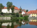
450 ft) above sea level. The village is situated on the right bank of the Blanice River, on the shore of the Podkostelní Pond. Historically, the spot was...
6 KB (420 words) - 12:30, 22 July 2024