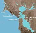
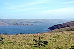
Bolinas Bay is a small bay, approximately 5 miles (8 km) long, on the Pacific coast of California in the United States. It is in Marin County, north of...
2 KB (147 words) - 02:22, 10 September 2023

Francisco. Bolinas lies west of the San Andreas Fault, which runs the length of Bolinas Lagoon and continues northward through Olema Valley and Tomales Bay. Bolinas...
32 KB (3,067 words) - 23:32, 14 August 2024
Bolinas. It is a part of the Greater Farallones National Marine Sanctuary. In 1974, Aubrey Neasham and William Pritchard wrote in support of Bolinas Lagoon...
4 KB (349 words) - 17:47, 9 April 2024
Yakutat Bay Alamitos Bay Bodega Bay Bolinas Bay Drakes Bay Estero Bay Grizzly Bay Half Moon Bay Humboldt Bay Monterey Bay Morro Bay Richardson Bay San Diego...
6 KB (537 words) - 22:48, 6 March 2024
Fringe theories on the location of New Albion (category History of the San Francisco Bay Area)
the way the artist of the Hondius Broadside inset viewed the site. Two Bolinas Bay locations have been proposed: George Epperson believed Drake stayed at...
52 KB (7,047 words) - 17:15, 20 August 2024

bays along the Pacific Coast include Bodega Bay, Tomales Bay, Drakes Bay, Bolinas Bay, and Half Moon Bay. The largest rivers are the Sacramento and San...
7 KB (785 words) - 10:08, 14 June 2022

valley? See it from Bolinas Ridge". Archived from the original on April 4, 2012. Retrieved August 18, 2010. "Fire Management Units: Bolinas Ridge". Retrieved...
5 KB (475 words) - 17:04, 13 September 2024

pier-wharf in Bolinas, California in Marin County built in the 1850s. Lumber was loaded onto barges (lighters), then towed through Bolinas Lagoon to deeper...
2 KB (216 words) - 14:53, 11 September 2023

Yenne, Bill (2004). The Missions of California. San Diego, CA: Thunder Bay Press. pp. 18f. ISBN 1592233198. A Description of California in 1828 by José...
46 KB (4,135 words) - 01:41, 15 October 2024

the original on 28 January 2013. Retrieved 3 November 2012. "Station Bolinas Bay, California" (PDF). U.S. Coast Guard History Program. United States Coast...
238 KB (10,409 words) - 10:58, 28 June 2024
Poets and Community in Bolinas, California, 1967–1980. Aylward, Jamie (November 11, 2018). "Recommended Reading on The Bolinas Scene". Adobe Books Blog...
4 KB (375 words) - 22:17, 14 May 2024
The fault divides the Point Reyes Peninsula through Tomales Bay in the north, and the Bolinas Lagoon in the south. The Bear Valley Visitor Center in Point...
12 KB (1,165 words) - 00:53, 18 October 2024

Mount Tamalpais (category Landmarks in the San Francisco Bay Area)
about 59 inches (1,500 mm) near the Bolinas Ridge, close to the Pacific Ocean. Both Mount Tamalpais and the Bolinas Ridge force moisture out of the air...
32 KB (3,638 words) - 12:26, 13 September 2024

Coast Miwok (category History of the San Francisco Bay Area)
and Bolinas Bay) appeared in the Mission San Francisco Book of Marriages. Local tribes from farther and farther north along the shore of San Pablo Bay moved...
28 KB (3,361 words) - 20:50, 15 October 2024

Stinson Beach, California (category San Francisco Bay Area beaches)
Beach is located east-southeast of Bolinas, right across the channel that terminates the bay mouth bar of the Bolinas Lagoon. at an elevation of 26 feet...
38 KB (3,988 words) - 23:33, 13 August 2024

San Gregorio Fault (category Geography of the San Francisco Bay Area)
Pacific Ocean just south of Monterey Bay, and the northern end is about 20 km northwest of San Francisco, near Bolinas Bay, where the San Gregorio intersects...
3 KB (318 words) - 08:54, 29 January 2024

Point Reyes (category Landforms of the San Francisco Bay Area)
to the Point Reyes Peninsula, the region bounded by Tomales Bay on the northeast and Bolinas Lagoon on the southeast. The majority of the peninsula as well...
43 KB (5,454 words) - 23:37, 17 October 2024
The Fog (redirect from Antonio Bay)
location at several other cities in California, including Point Reyes; Bolinas; Inverness; and the Episcopal Church of the Ascension in Sierra Madre....
34 KB (3,890 words) - 22:52, 14 October 2024

Tamalpais-Homestead Valley, and the West Marin communities of Muir Beach, Bolinas and Stinson Beach. Mill Valley School District is the largest feeder for...
93 KB (9,510 words) - 18:36, 6 October 2024
California Paleontology in California Balinas Point at Fossilworks.org Bolinas Bay at Fossilworks.org Waddell Creek at Fossilworks.org J. C. Clark. 1981...
3 KB (214 words) - 19:49, 20 November 2022
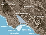
(233404) Arroyo Hondo Watercourses which feed into Bolinas Lagoon, numbered clockwise from Bolinas to Stinson Beach: Pine Gulch Creek (234476) Copper...
36 KB (2,916 words) - 05:39, 31 July 2024

Post. Bolinas, CA. September 1997. Retrieved 2015-05-05. Norman Carrigg (August 2004). "Marin General Hospital Update". Coastal Post. Bolinas, CA. Retrieved...
12 KB (872 words) - 21:47, 6 April 2024
outside the bay, including the Bolinas Lagoon, and contributed to the growth of activism against pollution, after thousands of Bay Area residents volunteered...
6 KB (525 words) - 15:42, 26 March 2024

Peresyp (redirect from Bay-mouth bar)
A peresyp (пересыпь) or a bay-mouth bar is a narrow sandbar that rises above the water level (like a spit) and separates a liman or a lagoon from the...
4 KB (366 words) - 04:54, 27 August 2024
This list of museums in the San Francisco Bay Area is a list of museums, defined for this context as institutions (including nonprofit organizations,...
58 KB (205 words) - 00:11, 29 December 2023

High School in Larkspur, California. Feeder school districts include: Bolinas-Stinson Union, Kentfield, Lagunitas, Larkspur-Corte Madera, Mill Valley...
7 KB (431 words) - 19:59, 23 July 2024
Alameda manzanita, found in the eastern San Francisco Bay Area Arctostaphylos virgata, common names Bolinas manzanita and Marin manzanita, found in Marin County...
8 KB (562 words) - 03:44, 22 August 2022

Mill Valley, California (redirect from Bay Junction, California)
followed by those from areas now known as Mill Valley, Belvedere, Tiburón and Bolinas. They called themselves the "Huimen" people. At the mission, they were...
78 KB (8,470 words) - 22:39, 19 October 2024

The Marconi-RCA Bolinas Transmitting Station, on Mesa Road in Bolinas, Marin County, California, was listed on the National Register of Historic Places...
3 KB (211 words) - 00:38, 6 March 2024
block commercial development of Bolinas Lagoon in western Marin County, leading the way for the protection of Tomales Bay to the north. Today, Audubon Canyon...
8 KB (816 words) - 23:40, 7 June 2024