
State Route 275 (SR 275) is an unsigned state highway connecting West Sacramento, California and Downtown Sacramento. Since 1996, the highway has been...
21 KB (2,509 words) - 06:28, 22 August 2023
Highway 275 (Maharashtra) Japan National Route 275 Interstate 275 (multiple highways) U.S. Route 275 Alabama State Route 275 California State Route 275 Connecticut...
2 KB (143 words) - 22:59, 4 April 2024

State Route 18 (SR 18) is a state highway in the U.S. state of California. It serves as a primary route into the San Bernardino Mountains, both from the...
16 KB (1,472 words) - 06:03, 7 February 2024

Transportation in the Sacramento metropolitan area (category Transportation in Sacramento, California)
part of West Sacramento, a short spur route peels away from US 50 in the form of California State Route 275 (SR 275), providing direct access to the Tower...
45 KB (4,753 words) - 02:04, 27 June 2024

state highways in the U.S. state of California that have existed since the 1964 renumbering. It includes routes that were defined by the California State...
106 KB (856 words) - 02:21, 22 May 2024

State Route 160 (SR 160) is a state highway in the U.S. state of California consisting of two sections. The longer, southern, section is a scenic highway...
30 KB (3,523 words) - 03:33, 12 May 2024

Legislature. Statutes of California. State of California. Ch. 29 p. 275.: "Route 11 is from Route 75 near Antioch to the Nevada State line near Lake Tahoe...
63 KB (6,126 words) - 14:39, 11 July 2024

California is a state in the Western United States, lying on the American Pacific Coast. It borders Oregon to the north, Nevada and Arizona to the east...
278 KB (24,057 words) - 06:41, 21 July 2024

State Route 84 (SR 84) is a state highway in the U.S. state of California that consists of two unconnected segments, one in the San Francisco Bay Area...
24 KB (1,815 words) - 02:21, 27 June 2024

State Route 273 (SR 273) is a state highway in the U.S. state of California that serves as a business loop of Interstate 5 that travels directly through...
6 KB (477 words) - 06:28, 22 August 2023

through Sacramento, California, United States. The route is also colloquially referred to as "Cap City Freeway" and "Biz 80". The entire route is a freeway....
27 KB (2,351 words) - 14:35, 11 July 2024

part of State Route 17 (SR 17) together with the Nimitz Freeway. This section of I-80 has a top speed of 65 mph (105 km/h), unlike California's top speed...
69 KB (4,647 words) - 06:08, 12 May 2024

State Route 153 (SR 153) is a very short state highway in the U.S. state of California in El Dorado County. It extends only 0.5 miles (0.80 km) from the...
6 KB (764 words) - 06:04, 22 August 2023

miles (805 km), the route was co-signed with other US routes for much of its length. When California deleted most of its U.S. Highways in the mid-1960s,...
13 KB (1,260 words) - 06:43, 29 June 2024

Interstate Highway in the San Francisco Bay Area of Northern California. It runs from I-680 and US Route 101 (US 101) in San Jose to King and 5th streets in San...
32 KB (2,567 words) - 20:21, 18 May 2024
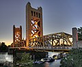
maintained by the California Department of Transportation as part of State Route 275 and connects West Capitol Avenue and Tower Bridge Gateway in West Sacramento...
15 KB (1,340 words) - 19:00, 29 May 2024

State Route 216 (SR 216) is a state highway in the U.S. state of California. It is a loop of State Route 198 in Tulare County, running from Visalia to...
4 KB (377 words) - 06:19, 22 August 2023

highway in the country. In 1964, the state of California renumbered its highways, and most of the route within California was transferred to other highways...
61 KB (6,447 words) - 01:22, 20 July 2024

271 State Route 273 State Route 275 Interstate 280 State Route 281 (part) State Route 282 State Route 283 State Route 284 State Route 299 (part) State Route...
15 KB (1,015 words) - 22:07, 22 March 2024
project is being built in sections. As of 2024, the state was targeting completion of a 171-mile (275 km) long Initial Operating Segment (IOS) connecting...
230 KB (21,313 words) - 18:52, 19 July 2024

Interstate 80 (redirect from Interstate 80 (California–New Jersey))
Francisco, California, to Teaneck, New Jersey, in the New York metropolitan area. The highway was designated in 1956 as one of the original routes of the...
36 KB (3,376 words) - 00:48, 25 June 2024

miles (4,859 km) from Interstate 80 (I-80) in West Sacramento, California, to Maryland Route 528 (MD 528) in Ocean City, Maryland, on the Atlantic Ocean...
39 KB (3,842 words) - 23:55, 7 May 2024

List of auxiliary Interstate Highways (redirect from Auxiliary route (Interstate))
the route has both ends at Interstates, but not at the same Interstate on both ends, and is assigned an odd first digit. Another example is I-275 in Tennessee;...
157 KB (1,771 words) - 00:56, 22 July 2024

Interstate 40 (redirect from Interstate 40 (California–North Carolina))
length in the state. A sign in California showing the distance to Wilmington, North Carolina, has been stolen several times. I-40 is a main route to the South...
65 KB (6,206 words) - 01:31, 12 July 2024

Fremont and Omaha. That route was decommissioned when US 275 was extended northwest from Council Bluffs, Iowa. Part of that route is today's Nebraska Highway...
23 KB (1,251 words) - 19:50, 19 June 2024

sentenced to life in prison. Chowchilla is located in California's Central Valley. Via California Route 99, it is 16 miles (26 km) northwest of Madera, the...
22 KB (2,046 words) - 18:31, 8 July 2024
U.S. Route 50 (US 50) is a part of the United States Numbered Highway System that runs from West Sacramento, California, to Ocean City, Maryland. In the...
21 KB (1,665 words) - 11:28, 12 June 2023

State Route 245 State Route 254 (Avenue of the Giants) State Route 262 (Mission Boulevard) State Route 267 State Route 269 State Route 275 (Tower Bridge...
76 KB (5,585 words) - 13:59, 22 July 2024

and is now the BNSF. Amtrak's California Zephyr passenger rail service also parallels this route. U.S. 34 in the state of Iowa is officially designated...
14 KB (1,252 words) - 12:51, 27 May 2024

Legislature. Statutes of California. State of California. Ch. 385 p. 1177.: "Route 70 is from Route 99 near Catlett Road to Route 395 near Hallelujah Junction...
46 KB (5,184 words) - 13:45, 6 July 2024