
Caney is a town in Atoka County, Oklahoma, United States. The population was 185 as of the 2020 Census. A post office was established at Caney Switch,...
8 KB (609 words) - 23:41, 2 July 2024
inhabitants as Caney or Caney Creek Caney, Oklahoma, in Atoka County Caney, Cherokee County, Oklahoma In Cuba: El Caney Caney Creek (disambiguation) This disambiguation...
344 bytes (74 words) - 12:56, 12 August 2021
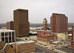
south of the Kansas border. It is the county seat of Washington County. The Caney River runs through Bartlesville. Bartlesville is the primary city of the...
40 KB (3,594 words) - 18:41, 28 August 2024
Caney Creek is a watercourse in Adair County and Cherokee County in Oklahoma. It forms just southeast of Stilwell and travels on an arc generally northwest...
2 KB (116 words) - 06:24, 31 August 2024

out of the town of Wann Oklahoma in northern Nowata County Oklahoma, entered the town at Golden Avenue, then came south on Caney Street (old U-75) for 0...
11 KB (1,295 words) - 23:39, 7 May 2024
Palo Duro Creek Coldwater Creek Wolf Creek Little River Illinois River Caney Creek Baron Fork Flint Creek Neosho River (Grand River) Elk River Buffalo...
9 KB (497 words) - 22:00, 10 March 2024
Caney Ridge is an unincorporated community and census-designated place (CDP) in Cherokee County, Oklahoma, United States, within the Cherokee Nation....
4 KB (176 words) - 17:22, 25 September 2023
inhabitants as "Caney Creek" Caney Creek (Pine Creek tributary) in Ozark County, Missouri Caney Creek (Scott County, Missouri) Caney Creek (Oklahoma), located...
557 bytes (108 words) - 13:00, 12 August 2021
Caney is a census-designated place (CDP) in Cherokee County, Oklahoma, United States, within the Cherokee Nation. It was first listed as a CDP prior to...
4 KB (163 words) - 17:18, 25 September 2023

The Caney River (Lenape: Kènii Sipu ) is a 180-mile-long (290 km) river in southern Kansas and northeastern Oklahoma. The river is a tributary of the Verdigris...
7 KB (463 words) - 03:55, 4 December 2023

(/ˈoʊseɪdʒ/) is the largest county by area in the U.S. state of Oklahoma. Created in 1907 when Oklahoma was admitted as a state, the county is named for and is...
27 KB (2,684 words) - 19:43, 27 April 2024
Cherokee County is a county located in the U.S. state of Oklahoma. As of the 2020 census, the population was 47,078. Its county seat is Tahlequah, which...
23 KB (1,750 words) - 19:23, 15 September 2024

Oklahoma is a state located in the Southern United States. According to the 2020 census, Oklahoma is the 28th most populous state with 3,959,353 inhabitants...
89 KB (234 words) - 00:56, 17 September 2024
county in Oklahoma by land area and smallest by total area. It lies in the Eastern Lowlands physiographic region, and is drained by the Caney River. Lakes...
15 KB (1,290 words) - 13:59, 15 September 2024
water. The largest body of water is Lake Oologah. The main streams are the Caney River and the Verdigris River. There are also several smaller creeks and...
22 KB (1,662 words) - 03:28, 13 October 2024
The following is a list of lakes in Oklahoma located entirely (or partially, as in the case of Lake Texoma) in the state. Swimming, fishing, and/or boating...
30 KB (722 words) - 15:16, 23 February 2024

approximately 20 mi north of Tulsa, and lies within a triangle formed by the Caney River, Verdigris River and Bird Creek. According to the United States Census...
14 KB (1,173 words) - 17:11, 22 August 2024
Township south of nearby Caney, Kansas, in northern Washington County, through what was Hulah, east of Bowring, then south across the Caney River, then on the...
8 KB (465 words) - 12:10, 22 August 2024

Oklahoma Department of Corrections operates the Mack Alford Correctional Center in an unincorporated area, near Stringtown. Atoka (county seat) Caney...
20 KB (1,656 words) - 14:25, 13 October 2024
Cherokee Timberlake High School, Helena Atoka High School, Atoka Caney High School, Caney Stringtown High School, Striptown Tushka High School, Atoka Balko...
23 KB (2,015 words) - 14:31, 10 June 2024
present-day Antlers, Oklahoma) on its south, and the mountains north of present-day Sardis Lake on its north. Johns named the valley Big Caney Valley, due to...
9 KB (1,370 words) - 12:16, 7 August 2024

state of Oklahoma. As of the 2020 census, the population was 669,279, making it the second-most populous county in the state, behind only Oklahoma County...
44 KB (3,663 words) - 04:49, 13 October 2024

County, US-69/75 bypass Caney and Tushka to the west before coming to the SH-3/7 junction in the county seat of Atoka, Oklahoma; at this junction, SH-3...
23 KB (1,207 words) - 20:03, 14 July 2024
Public Schools #93, Helena Atoka Public Schools #15, Atoka Caney Public Schools #26, Caney Harmony Public School #21, Atoka Lane Public School #22, Lane...
40 KB (2,834 words) - 15:29, 13 October 2024
Johnston. The relay crossed the eastern part of Kansas southward to Oklahoma. In Oklahoma City, governor George Nigh was joined by Jim Thorpe's son Richard...
183 KB (7,545 words) - 05:40, 18 September 2024

United States Army Corps of Engineers damming the Caney River in northeastern Osage County, Oklahoma, within the Osage Indian Reservation. Hulah is an...
4 KB (287 words) - 16:30, 24 August 2024

District was consolidated with Ramona, Vera, and Oglesby to become the Caney Valley School District. The elementary school is located in Ochelata and...
7 KB (580 words) - 02:54, 10 October 2024
lake is also a popular fishing spot. Caney Mountain lies to Sobol's north and Bull Mountain is to its south. Caney Mountain Trail connects the Sobol area...
2 KB (194 words) - 11:28, 22 August 2024
The Kansas, Oklahoma Central and Southwestern Railway (“KOC&S”) was a railroad which in 1899 built tracks from a point near Caney, Kansas to what became...
7 KB (759 words) - 20:56, 23 April 2024
The state of Oklahoma historically had civil townships. On August 5, 1913, voters passed the Oklahoma Township Amendment, also known as State Question...
52 KB (153 words) - 01:58, 27 July 2023