
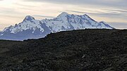
Casiri (possibly from Aymara for bawler, is a mountain in the Andes of Peru, about 5,647 metres (18,527 ft) high. It is located in the Arequipa Region...
2 KB (95 words) - 23:39, 3 May 2021
Casiri may refer to: Casiri (Arequipa), a mountain in Arequipa Region, Peru Casiri (Tacna), a volcano in Tacna Region, Peru Miguel Casiri (1710–1791)...
357 bytes (66 words) - 15:40, 19 July 2019

Arequipa (Quechua: Ariqipa) is a department and region in southwestern Peru. It is the sixth largest department in Peru, after Puno, Cuzco, Madre de Dios...
14 KB (797 words) - 15:06, 10 July 2024
Icma (redirect from Ikma (Arequipa))
700 ft) high. It is located in the Arequipa Region, Castilla Province, Chachas District. Icma lies southwest of Casiri at a lake named Cochapunco. escale...
2 KB (93 words) - 05:31, 15 April 2022
in the Arequipa Region, Castilla Province, on the border of the districts of Chachas and Choco. Choquepirhua is situated south of Chila. Casiri Cerani...
2 KB (193 words) - 05:23, 15 April 2022
Cerani and Casiri. "Cerro Yuraccacsa". IGN, Peru. Retrieved May 27, 2015. escale.minedu.gob.pe - UGEL map of the Castilla Province (Arequipa Region) v...
2 KB (112 words) - 02:05, 16 April 2022
Bolivia – Chile 5,647 Casiri (Arequipa) 15°27′46″S 72°10′17″W / 15.46278°S 72.17139°W / -15.46278; -72.17139 (Q'asiri (Arequipa)) Peru 5,644 Huacshash...
61 KB (174 words) - 21:34, 18 April 2024

Misti (category Mountains of Arequipa Region)
Andes mountains in southern Peru, rising above Peru's second-largest city, Arequipa. It is a conical volcano with two nested summit craters, the inner one...
113 KB (13,649 words) - 15:20, 4 May 2024
Chachani, El Misti, Ubinas, Ticsani, Tutupaca, Yucamane, Purupuruni and Casiri. Ubinas is the most active volcano in Peru; Huaynaputina, El Misti, Sabancaya...
171 KB (18,931 words) - 23:46, 26 April 2024

Sabancaya (category Mountains of Arequipa Region)
in the Andes of southern Peru, about 70 kilometres (43 mi) northwest of Arequipa. It is considered part of the Central Volcanic Zone of the Andes, one of...
57 KB (6,551 words) - 05:57, 18 March 2024

Pichu Pichu (category Mountains of Arequipa Region)
reaches a height of 5,664 metres (18,583 ft). It lies east of the city Arequipa and together with its neighbours Misti and Chachani is part of the Central...
42 KB (4,264 words) - 01:45, 15 June 2024

Hualca Hualca (category Mountains of Arequipa Region)
Volcanoes in Peru that are part of the Central Volcanic Zone include Ampato, Casiri, Chachani, Coropuna, El Misti, Huaynaputina, Pichu Pichu, Sabancaya, Sara...
14 KB (1,404 words) - 18:22, 4 October 2023
Cerani (mountain) (category Mountains of Arequipa Region)
(possibly from Quechua for "lake reservoir") and southwest of Yuraccacsa and Casiri near the volcanic zone in the west. mapcarta.com "Cerro Cerani", retrieved...
2 KB (142 words) - 17:05, 22 March 2023

southern Peru, approximately 60 kilometres (37 mi) east of the city of Arequipa. Part of the Central Volcanic Zone of the Andes, it rises 5,672 metres...
64 KB (7,261 words) - 19:37, 20 February 2024

Chachani (category Mountains of Arequipa Region)
group in southern Peru, 22 kilometres (14 mi) northwest of the city of Arequipa. Part of the Central Volcanic Zone of the Andes, it is 6,057 metres (19...
42 KB (4,535 words) - 09:33, 9 March 2024

Ampato (category Mountains of Arequipa Region)
southern Peru. It lies about 70–75 kilometres (43–47 mi) northwest of Arequipa and is part of a north-south chain that includes the volcanoes Hualca Hualca...
22 KB (2,684 words) - 11:44, 5 January 2024

Coropuna (category Mountains of Arequipa Region)
Sabancaya, Chachani, Misti, Ubinas, Huaynaputina, Tutupaca, Yucamane and Casiri. Also found nearby are Neogene-age calderas. Sixteen volcanoes in Peru are...
126 KB (13,485 words) - 08:30, 4 May 2024
Solimana (volcano) (category Mountains of Arequipa Region)
and subsequent erosion. The volcano is glaciated. It is situated in the Arequipa Region, Condesuyos Province, in the districts of Chichas and Salamanca...
21 KB (2,292 words) - 07:49, 7 April 2024
Chila mountain range (category Mountains of Arequipa Region)
range is Chila at 5,654 m (18,550 ft). Other mountains are listed below: Casiri, 5,647 m (18,527 ft) Mismi, 5,597 m (18,363 ft) Minaspata, 5,555 m (18,225 ft)...
5 KB (417 words) - 08:13, 25 December 2023

volcanoes El Misti, Sabancaya and Ubinas; the volcanoes Andagua volcanic field, Casiri, Chachani, Coropuna, Firura, Huaynaputina, Tutupaca and Yucamane may have...
38 KB (4,160 words) - 13:42, 15 January 2024

sedimentary rocks of Mesozoic age, forming the "Antofalla domain" of the Arequipa-Antofalla tectonic block that originated separately from South America...
59 KB (6,274 words) - 22:51, 6 July 2024
Firura (category Mountains of Arequipa Region)
an extinct volcano of the Central Andean Volcanic Belt, located in the Arequipa Region of southern Peru. Together with Sara Sara, Solimana and Coropuna...
6 KB (564 words) - 15:43, 14 February 2024

Chachani, El Misti, Ubinas, Huaynaputina, Ticsani, Yucamane, Purupuruni and Casiri. During historical times, major eruptions took place in Peru at El Misti...
32 KB (3,615 words) - 17:57, 10 January 2024
Bolivia. The Central Andes are underlaid by the Paleoproterozoic-Paleozoic Arequipa-Antofalla terrane. The Central Andes started to form 70 mya. Previously...
25 KB (3,121 words) - 03:39, 19 May 2024

Andagua volcanic field (category Landforms of Arequipa Region)
in southern Peru, 135 kilometres (84 mi) from the city of Arequipa and within the Arequipa Department and its provinces Castilla, Caylloma and Condesuyos...
33 KB (4,205 words) - 07:58, 6 April 2024

(Proterozoic) crust in the north, which is made up by the Chilenia terrane and the Arequipa-Antofalla craton, respectively. This transition area appears to coincide...
18 KB (2,137 words) - 17:02, 22 December 2022
E. (1 September 2005). "A rare case of grass flow induced by the M8.4 Arequipa earthquake, June 2001, in the Altiplano of Northern Chile". Quaternary...
33 KB (3,774 words) - 15:45, 22 November 2023

have been dated at 1.05±0.04 mya. The Huambo field is located within the Arequipa crustal domain. "Huambo". Global Volcanism Program. Smithsonian Institution...
3 KB (314 words) - 18:43, 6 May 2021

which may coincide with the suture between the Chilenia terrane and the Arequipa-Antofalla block. Being about 1,200 m (3,900 ft) high over its base, Isluga...
15 KB (1,619 words) - 13:01, 12 February 2024

these lineaments in the region trends north-northeast and separates the Arequipa-Antofalla terrane from the Pampia terrane. The regional geography developed...
41 KB (4,653 words) - 02:42, 8 July 2024