
Chřiby (German: Marsgebirge, the "Mars Mountains") is a geographic region of the Czech Republic, part of the Central Moravian Carpathians of the Outer...
1 KB (166 words) - 06:18, 31 October 2024

are the Chřiby highlands with the highest point Brdo (587 m). The Upper Morava Valley passes through from the west among the highlands of Chřiby highlands...
17 KB (1,618 words) - 00:37, 21 October 2024

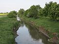
of Kyjov. The Kyjovka originates in the territory of Staré Hutě in the Chřiby range at an elevation of 518 m (1,699 ft) and flows to Lanžhot, where it...
4 KB (357 words) - 06:49, 10 November 2024
river. The Litava originates in the territory of Chvalnov-Lísky in the Chřiby range at an elevation of 495 m (1,624 ft) and flows to Židlochovice, where...
4 KB (331 words) - 06:58, 10 November 2024

ready in January 1939, and construction in Moravia began on 24 January in Chřiby on the Zástřizly – Lužná segment. The construction in Bohemia from Prague...
28 KB (1,842 words) - 14:52, 8 November 2024

ready in January 1939, and construction in Moravia began on 24 January in Chřiby on the Zástřizly - Lužná segment. The construction in Bohemia from Prague...
41 KB (2,260 words) - 19:19, 3 January 2025

lies in the Upper Morava Valley. A small southern part extends into the Chřiby range. The highest point of the territory is the Obora hill at 322 m (1...
18 KB (1,569 words) - 13:00, 13 November 2024

an eponymous hill with an elevation of 508 metres (1,667 ft) within the Chřiby mountain range. The castle was built approximately in the first part of...
4 KB (544 words) - 19:06, 30 October 2024

of Congress. 2013. p. 375. Retrieved 17 November 2021. Žižlavský, Bořek; Chřiby, Expedice. "Cimburk Castle". m.taggmanager.cz. Retrieved 17 November 2021...
1 KB (87 words) - 17:41, 3 November 2023

Ždánice Forest (Ždánický les) Litenčice Hills (Litenčická pahorkatina) Chřiby Kyjov Hills (Kyjovská pahorkatina) (CZ/SK: Slovensko-moravské Karpaty) White...
32 KB (2,939 words) - 01:07, 13 December 2024

began on the Zástřizly – Lužná segment on 24 January in Zástřizly in the Chřiby mountains. The German occupation of Czechoslovakia brought only small technical...
10 KB (922 words) - 07:45, 22 December 2024

winter (24.6% by number), in Białowieża Forest, Poland (14.3%), in the Chřiby uplands of the Czech Republic (8.5%) and in Forêt de Bercé, France (12%)...
177 KB (22,760 words) - 12:55, 3 January 2025
Barbořík family, Luhačovice 2004 – house in Míkovice 2004 – view of Brdo, Chřiby 2004 – monument for the Jabůrkov family in the Lesní cemetery, Zlín, with...
7 KB (755 words) - 05:55, 7 June 2023

province (Bohemian Massif) – Bohemian-Moravian Highland and the Carpathians (Chřiby) since ancient times. Here ran the most important trade routes from southern...
3 KB (243 words) - 18:13, 27 October 2024

eastern part of Moravia and situated between the White Carpathians and the Chřiby mountains, has retained its non-Czech identity in its designation "Slovácko"...
129 KB (15,496 words) - 14:11, 5 January 2025
Republic and is steeped in local mythology and traditions. Stela ran to the Chřiby forests. The environment is based on the Cyril and Methodius Trail near...
12 KB (1,177 words) - 20:01, 6 August 2024

Litenčice Hills (Litenčická pahorkatina) IXB-2 590 293.7 518 (Hradisko) Chřiby IXB-3 335 342.6 587 (Brdo) Kyjov Hills (Kyjovská pahorkatina) IXB-4 482...
17 KB (292 words) - 04:08, 24 July 2024

Litenčice Hills, the southern part lies in a forested landscape of the Chřiby range. The highest point is the hill Hrad at 552 metres (1,811 ft) above...
5 KB (320 words) - 05:45, 19 September 2024

territory lies in the Kyjov Hills, only a small northern part lies in the Chřiby highlands. The highest point is the hill Lenivá hora at 463 m (1,519 ft)...
10 KB (887 words) - 07:00, 24 October 2024

and 34 km (21 mi) southwest of Zlín. It lies on the border between the Chřiby highlands and Kyjov Hills. The highest point is at 536 m (1,759 ft) above...
6 KB (313 words) - 12:06, 18 September 2024

Uherské Hradiště and 23 km (14 mi) southwest of Zlín. It lies mostly in the Chřiby highlands, only the southernmost part of the municipal territory extends...
7 KB (537 words) - 12:49, 18 September 2024

is located about 14 kilometres (9 mi) southwest of Zlín. It lies in the Chřiby range. The highest point is the hill Březová at 411 m (1,348 ft) above sea...
5 KB (262 words) - 13:00, 27 October 2024

trerritory lies in the Litenčice Hills, only the southern part lies in the Chřiby range. The highest point is the hill Na Kopě at 422 metres (1,385 ft) above...
6 KB (389 words) - 05:48, 19 September 2024

the Litenčice Hills. The western part lies in a forested landscape of the Chřiby range and includes the highest point of Koryčany, the hill Ocásek at 553 m...
8 KB (549 words) - 17:54, 27 October 2024

Highlands, but the area on the right bank of the Morava extends into the Chřiby range. The highest point is the hill Maková at 338 m (1,109 ft) above sea...
9 KB (737 words) - 03:53, 24 October 2024

centre), Kyjov Hills (a strip from west to east), Ždánice Forest (northwest), Chřiby (small part in the northeast), Vizovice Highlands (east), White Carpathians...
11 KB (713 words) - 04:06, 22 October 2024

Uherské Hradiště and 22 km (14 mi) southwest of Zlín. It lies mostly in the Chřiby highlands, only the southernmost part of the municipal territory extends...
6 KB (382 words) - 13:18, 27 October 2024

from southwest to north), Kyjov Hills (a strip from west to north) and Chřiby (northwest). The highest point of the district is the mountain Velká Javořina...
12 KB (698 words) - 12:45, 21 October 2024

six geomorphological mesoregions: Upper Morava Valley (north and centre), Chřiby (southwest), Moravian-Silesian Foothills (northeast), Hostýn-Vsetín Mountains...
11 KB (628 words) - 21:36, 9 November 2024

the northwest), Lower Morava Valley (a small part in the southwest), and Chřiby (a small part in the west). The highest point of the district is the mountain...
11 KB (650 words) - 01:01, 21 October 2024