Chittering is a town and rural district approximately 70 km NNE of Perth, Western Australia. It is located along the Brockman River within the Shire of...
2 KB (126 words) - 08:45, 5 February 2023
The Shire of Chittering is a local government area in the Wheatbelt region of Western Australia, covering an area of about 1,200 square kilometres (460 sq mi)...
7 KB (426 words) - 06:56, 25 February 2023
Chittering may refer to: Chittering, Cambridgeshire, England Chittering, Western Australia This disambiguation page lists articles about distinct geographical...
119 bytes (44 words) - 02:00, 28 December 2019
Lower Chittering is a locality in the Shire of Chittering within part of the Chittering Valley. The Chittering Valley is well known for its abundance of...
2 KB (201 words) - 06:22, 23 October 2023

Blackwood Valley, Manjimup, Pemberton, Peel, Chittering Valley, Perth Hills, and Geographe. Western Australia has five sister states: East Java, Indonesia...
90 KB (8,292 words) - 00:49, 5 July 2024
route continues along Chittering Road to Chittering, following the Brockman River and its tributaries. It deviates onto Chittering Valley Road, continuing...
37 KB (3,154 words) - 00:17, 5 January 2024

Western Australia (WA) is divided into regions according to a number of systems. The most common system is the division of the state by the Government...
28 KB (2,217 words) - 01:51, 5 July 2024

Sunset Coast Gingin Swan Valley Chittering Finally, the northwestern Shire of Dandaragan is promoted as part of Australia's Coral Coast region due to the...
18 KB (1,526 words) - 04:20, 1 May 2024
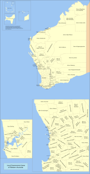
There are 137 local government areas (LGAs) in Western Australia, which comprise 27 cities, 102 shires, and 8 towns that manage their own affairs to the...
59 KB (1,456 words) - 23:12, 21 June 2024

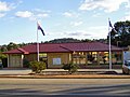
Muchea. Main building of the Shire of Chittering Chittering Tourist Centre and Bindoon Post Office Australian Bureau of Statistics (28 June 2022). "Bindoon...
9 KB (883 words) - 19:29, 25 April 2024

Seabird is a small coastal town north of Perth, Western Australia in the Shire of Gingin, situated halfway between Two Rocks and Lancelin overlooking...
4 KB (350 words) - 03:19, 1 April 2023

Australian rules football is the most popular sport in Western Australia (WA). It is governed by the West Australian Football Commission (WAFC). Matches...
86 KB (4,204 words) - 01:45, 1 July 2024

Koorda is a town in the north eastern Wheatbelt region of Western Australia, approximately 236 kilometres (147 mi) east of Perth and 43 kilometres (27 mi)...
6 KB (378 words) - 16:16, 8 February 2023

Pithara is a small town in the wheatbelt region of Western Australia. It is located about 240 km north of Perth, in the Shire of Dalwallinu. At the 2011...
4 KB (438 words) - 05:42, 16 December 2023

Wagin /ˈweɪdʒɪn/ is a town and shire in the Wheatbelt region of Western Australia, approximately 225 km (139.81 mi) south-east of Perth on the Great Southern...
14 KB (1,211 words) - 18:18, 24 June 2024
Geography of Western Australia List of lakes of Australia List of lakes in Western Australia Gazetteer of Australia (1996). Belconnen, ACT: Australian Surveying...
20 KB (259 words) - 03:48, 25 January 2024

Southern Cross is a town in Western Australia, 371 kilometres (230.5 miles) east of state capital Perth on the Great Eastern Highway. It was founded in...
11 KB (767 words) - 04:42, 1 May 2024
Southern Cross on the Great Eastern Highway in the Wheatbelt region of Western Australia. Noongar originated in 1894 as Siding No. 10 on the Yilgarn Railway...
3 KB (208 words) - 08:33, 21 May 2023

originally Wolwolling, is a small town in the Wheatbelt region of Western Australia, located along the Great Southern Highway between Narrogin and Wagin...
4 KB (342 words) - 13:32, 10 February 2023

Gingin is a town in Western Australia, located on the Brand Highway 67 kilometres (42 mi) north of the Perth city centre. It is the council seat for the...
6 KB (645 words) - 12:22, 4 June 2024

Lancelin is a small fishing and tourist town 127 km north of Perth, Western Australia. It is within the Shire of Gingin at the end of Lancelin Road, and...
9 KB (612 words) - 03:52, 1 July 2024

town in the Central Midlands division of the Wheatbelt region of Western Australia, about 217 kilometres (135 mi) north of Perth. Ballidu is also 34...
5 KB (599 words) - 07:26, 9 February 2024

central Wheatbelt region of Western Australia, 229 kilometres (142 mi) east-southeast of the state capital, Perth, Western Australia, along State Route 40....
11 KB (977 words) - 19:31, 25 April 2024

Quairading is a Western Australian town located in the Wheatbelt region. It is the seat of government for the Shire of Quairading. The town was named for...
13 KB (1,334 words) - 11:51, 28 February 2024

townsite located 177 km north of Perth in the Wheatbelt region of Western Australia. At the 2021 census, Moora had a population of 1,755. Moora was one...
9 KB (577 words) - 13:19, 5 September 2023

Kondut is a small town in Wheatbelt region of Western Australia. The first European to visit and chart the area was the surveyor C Crossland in 1884....
2 KB (149 words) - 07:34, 14 February 2023
Dudinin is a small remote town located in the Shire of Kulin in Western Australia, with a population of 72. Dudinin is located 37 kilometres southeast...
3 KB (186 words) - 12:58, 1 April 2024
Irishtown is a locality in the Wheatbelt region of Western Australia near Northam. It is situated 7 km (4 mi) to the north of Northam and 85 km (53 mi)...
1 KB (78 words) - 11:44, 12 March 2024

Wandering is a town located in the Wheatbelt region of Western Australia, approximately 120 kilometres (75 mi) from the state capital, Perth, just off...
8 KB (586 words) - 05:34, 11 August 2023
locality between Merredin and Mukinbudin in the Wheatbelt region of Western Australia. It had a population of 104 at the 2006 census. Initially established...
3 KB (265 words) - 04:21, 1 May 2024