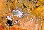
Chott Melrhir, (Arabic: شط ملغيغ) also known as Chott Melghir or Chott Melhir, is an endorheic chott-kind of salt lake in northeastern Algeria. It is the...
9 KB (905 words) - 18:25, 21 August 2024
of chotts. One example of a suspected Martian evaporite basin is Holden Crater. Chott el Djerid Chott ech Chergui Chott Melrhir Chott el Fejej Chott el...
5 KB (567 words) - 23:25, 19 November 2022
List of rivers of Algeria (section Chott Melrhir)
This is a list of rivers in Algeria. This list is arranged west to east by drainage basin, with respective tributaries indented under each larger stream's...
3 KB (221 words) - 17:31, 28 July 2023
kilometers (300 mi) approximately from west to east, and discharges into Chott Melrhir lake at about –40 meters (130 ft) below mean sea level, which is the...
5 KB (501 words) - 17:41, 15 January 2022

approximately 2.434 million km2. Qattara Depression, in Egypt. Chott Melrhir, in Algeria. Chott el Djerid, in Tunisia. The Okavango River, in the Kalahari...
33 KB (3,767 words) - 06:24, 6 May 2024
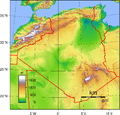
Taza, Théniet El Had, and Tlemcen. Elevation extremes: Lowest point: Chott Melrhir: −40 metres (−130 ft) Highest point: Mount Tahat: 2,908 metres (9,541 ft)...
30 KB (2,584 words) - 16:53, 6 August 2024

Ghuzayyil Libya −47 m (−154 ft) 6 Lake Moeris Egypt −43 m (−141 ft) 7 Chott Melrhir Algeria −40 m (−131 ft) 8 Shatt al Gharsah Tunisia −17 m (−56 ft) 9...
16 KB (471 words) - 16:00, 21 June 2024
basins, watersheds which do not drain to the sea. Chott Melrhir (Algeria) Chott Ech Chergui (Algeria) Chott el Hodna (Algeria) Tidikelt Depression (Algeria)...
12 KB (1,280 words) - 15:07, 10 April 2024
the genus of Melghirimyces which has been isolated from the salt lake Chott Melrhir in Algeria. Parte, A.C. "Melghirimyces". LPSN. "Melghirimyces algeriensis...
2 KB (125 words) - 02:46, 8 February 2023

Sea sea level 2764 m 9,068 ft Algeria Mount Tahat 3003 m 9,852 ft Chott Melrhir −40 m −131 ft 3043 m 9,984 ft American Samoa Lata Mountain on Ta‘ū...
49 KB (2,072 words) - 00:58, 1 August 2024

North Africa. The depressions are characteristically saline, variously chotts (saline lakes fed by groundwater and some winter rains) or sabkhas (coastal...
7 KB (616 words) - 19:52, 9 March 2024
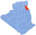
extensive palm plantations. Chott Melrhir, a large endorheic salt lake, lies in the north-central part of the province, while Chott Felrhir is a smaller salt...
6 KB (428 words) - 07:20, 20 March 2024

Pakistani-Indian border WGPSN Melrhir Lacuna 64°54′N 212°36′W / 64.9°N 212.6°W / 64.9; -212.6 (Melrhir Lacuna) 23 21 December 2010 Chott Melrhir, intermittent lake...
71 KB (4,674 words) - 21:00, 12 July 2024
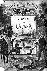
has media related to Invasion of the Sea. Qattara Depression Project Chott Melrhir Canavan, Gerry (2018). The Cambridge History of Science Fiction. Cambridge...
10 KB (1,049 words) - 15:26, 21 May 2024

companions took the road in the direction of the Sahara (Zeribet El Oued, Chott Melrhir, the Grand Erg Oriental, Debdeb and southern Tunisia) with the help...
21 KB (2,472 words) - 23:58, 17 August 2024
Range and is one of a large number of seasonal streams that empty into Chott Melrhir. It is bordered to the north by the municipality of Sidi Makhlouf, to...
19 KB (1,986 words) - 17:37, 7 June 2024

in the past, others continued through the Grand Erg Oriental towards Chott Melrhir. There are about 450 recent volcanic centres, of which about 400 are...
16 KB (1,808 words) - 21:05, 23 September 2022
Extreme points of Algeria High: Mount Tahat 3,003 m (9,852 ft) Low: Chott Melrhir −40 m (−131 ft) Land boundaries: 6,343 km Libya 982 km Tunisia 965...
19 KB (1,197 words) - 20:37, 17 August 2024

3,938 in 1998, with an annual growth rate of 2.8%. Hamraia is near Chott Melrhir, a large endorheic salt lake that lies to the north of the town. The...
7 KB (332 words) - 07:39, 11 October 2023
Rivers and lakes: Chott Melrhir, Mazafran, Oued El Harrach, Chiffa, Isser, Sebaou, Daas, Soummam, El Malah, El Hammam, Mekkera, Tafna, Chott Chergui, Seybouse...
16 KB (1,594 words) - 13:52, 10 February 2024

Pakistani-Indian border WGPSN Melrhir Lacuna 64°54′N 212°36′W / 64.9°N 212.6°W / 64.9; -212.6 (Melrhir Lacuna) 23 21 December 2010 Chott Melrhir, intermittent lake...
55 KB (1,269 words) - 13:00, 19 July 2024