Clarendon is an unincorporated community in Columbus County, North Carolina, United States. The community is located along a railroad and North Carolina...
3 KB (100 words) - 21:22, 11 December 2023
Clarendon, North Carolina Clarendon, Pennsylvania Clarendon, Texas Clarendon, Vermont Clarendon, Arlington, Virginia Clarendon County, South Carolina...
3 KB (396 words) - 13:58, 21 December 2022

Clarendon County is a county located below the fall line in the Coastal Plain region of U.S. state of South Carolina. As of the 2020 census, its population...
39 KB (3,319 words) - 20:54, 3 May 2024

Cape Fear River (redirect from Fear, Cape (river, North Carolina))
is a 191.08-mile-long (307.51 km) blackwater river in east-central North Carolina. It flows into the Atlantic Ocean near Cape Fear, from which it takes...
24 KB (1,935 words) - 03:30, 7 September 2024
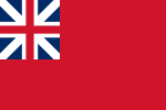
Province of South Carolina, originally known as Clarendon Province, was a province of the Kingdom of Great Britain that existed in North America from 1712...
15 KB (1,030 words) - 02:00, 2 May 2024

town in Clarendon County, South Carolina, United States. Per the 2020 census, the population was 814. Summerton is in southwestern Clarendon County at...
14 KB (984 words) - 03:12, 22 October 2024
settlement on the Cape Fear River, near present-day Wilmington, North Carolina, which he named Clarendon. From 1675 to 1677, the Province fought the Chowanoc Natives...
23 KB (2,275 words) - 15:18, 26 June 2024

County, South Carolina, United States. The city makes up the Sumter, SC Metropolitan Statistical Area. Sumter County, along with Clarendon and Lee counties...
40 KB (3,672 words) - 00:01, 24 October 2024

Turbeville is a town in Clarendon County, South Carolina, United States. The population was 766 at the 2010 census, up from 602 in 2000. Turbeville is...
11 KB (1,017 words) - 00:45, 7 May 2024
of North Carolina, originally known as Albemarle Province, was a proprietary colony and later royal colony of Great Britain that existed in North America...
33 KB (2,677 words) - 04:40, 16 August 2024

Hunter Coates, South Carolina Highway Patrol, South Carolina". Retrieved November 10, 2013. "I-95 Lake Marion Bridge (Clarendon County, 1968)". Retrieved...
26 KB (1,605 words) - 10:48, 11 September 2024

U.S. Route 521 (redirect from U.S. Route 521 (South Carolina–North Carolina))
(US 521) is a north–south United States Highway that traverses 177.3 miles (285.3 km), from Georgetown, South Carolina, to Charlotte, North Carolina. Though...
18 KB (632 words) - 04:23, 15 June 2024
North Santee is a census-designated place (CDP) in Clarendon County, South Carolina, United States. It was first listed as a CDP prior to the 2020 census...
6 KB (266 words) - 21:37, 12 July 2023
unincorporated community and census-designated place (CDP) in Clarendon County, South Carolina, United States. As of the 2010 census, its population was 429...
9 KB (850 words) - 13:51, 9 September 2024

Paxville is a town in Clarendon County, South Carolina, United States. The population was 185 at the 2010 census, down from 248 in 2000. The town was named...
9 KB (733 words) - 00:32, 7 May 2024
Earl of Clarendon (1609–1674), English historian and statesman Edward Hyde (died 1665), British MP for Salisbury Edward Hyde, 3rd Earl of Clarendon (1661–1723)...
757 bytes (127 words) - 06:46, 14 September 2020

South Carolina's 6th congressional district is in central and eastern South Carolina. It includes all of Allendale, Bamberg, Calhoun, Clarendon, Hampton...
42 KB (840 words) - 05:27, 17 October 2024
South Carolina (/ˌkærəˈlaɪnə/ KARR-ə-LY-nə) is a state in the Southeastern region of the United States. It borders North Carolina to the north and northeast...
128 KB (11,976 words) - 13:34, 23 October 2024

Pleasure Island is a coastal barrier island in Southeastern North Carolina, United States, just south of the City of Wilmington. Pleasure Island is located...
48 KB (6,318 words) - 23:25, 28 May 2024
This is a list of high schools in the U.S. state of South Carolina. Abbeville High School, Abbeville Calhoun Falls Charter School, Calhoun Falls Dixie...
27 KB (1,309 words) - 12:58, 22 August 2024
Dillon (Largest city: Dillon) Clarendon (Largest city: Manning) Trump won 6 of the 7 congressional districts. South Carolina—a Deep Southern Bible Belt state...
75 KB (1,980 words) - 00:24, 1 September 2024
Hickory Council in North Carolina did not integrate until 1974. There are six Boy Scouts of America (BSA) local councils in South Carolina. Headquarters located...
6 KB (630 words) - 19:05, 23 October 2024

area east of a line drawn from the northernmost point of old Clarendon County continued north-northeasterly to a point on the boundary line with Darlington...
28 KB (1,856 words) - 01:25, 21 September 2024
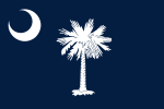
The flag of South Carolina is a symbol of the U.S. state of South Carolina consisting of a blue field with a white palmetto tree and white crescent. Roots...
16 KB (1,654 words) - 21:33, 14 October 2024

Fear River in Brunswick County, North Carolina, United States. Compared to the nearby city of Wilmington to the north, the village of Bald Head Island...
31 KB (3,587 words) - 06:24, 26 October 2024

North Myrtle Beach is a city in Horry County, South Carolina, United States. It was created in 1968 from four existing municipalities, and is located about...
15 KB (1,210 words) - 18:26, 27 February 2024
of North Carolina, South Carolina, Georgia and Florida—from Pender County, North Carolina, to St. Johns County, Florida. Coastal South Carolina’s half...
10 KB (966 words) - 21:02, 15 October 2024

The U.S. state of South Carolina is made up of 46 counties, the maximum allowable by state law. They range in size from 392 square miles (1,015 square...
27 KB (1,174 words) - 09:54, 3 October 2024

congressional districts in South Carolina. There have been as few as four and as many as nine congressional districts in South Carolina. The 9th district and the...
19 KB (883 words) - 20:49, 20 October 2024

continues as North Mill Street. The entire route is in Clarendon County. U.S. roads portal United States portal "Highway Logmile Report". South Carolina Department...
3 KB (240 words) - 02:23, 16 February 2024