
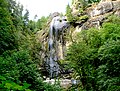
Cline Falls is a 20 ft-high (6.1 m) segmented steep cascade waterfall on the Deschutes River. It is approximately 4 miles (6.4 km) west of Redmond, Oregon...
15 KB (1,689 words) - 13:27, 26 April 2024

The Cline Falls axe attack refers to an unsolved attempted homicide that occurred on the evening of June 22, 1977, at the Cline Falls State Park in Deschutes...
14 KB (1,455 words) - 03:31, 14 August 2024
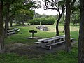
Cline Falls State Scenic Viewpoint (also known as Cline Falls State Park) is a state park near Redmond, Oregon, United States. It is located on the Deschutes...
10 KB (1,000 words) - 06:10, 1 August 2023

Multnomah Falls is a waterfall located on Multnomah Creek in the Columbia River Gorge, east of Troutdale, between Corbett and Dodson, Oregon, United States...
25 KB (2,457 words) - 08:48, 22 July 2024
Adelbert Cline (also known as C. A. Cline; August 28, 1850 – July 19, 1926) was an American pioneer who was an early settler in central Oregon. Cline’s family...
13 KB (1,257 words) - 12:58, 26 April 2024

and falls that now bear his name. Later, Cline attempted to establish a town along the west bank of the Deschutes River, near the foot of the Cline Buttes...
22 KB (2,222 words) - 21:48, 20 August 2024

largely the result. Plentiful salmon made parts of the river, such as Celilo Falls, hubs of economic activity for thousands of years. Today, Oregon's landscape...
196 KB (16,672 words) - 02:56, 5 September 2024

is just off the Cline Falls Highway, approximately one mile south of Highway 126. In addition to the resort's main area east of Cline Butte, there is...
18 KB (1,953 words) - 23:36, 22 April 2024

Oregon)) Cline Falls 1117620 Bonnie Falls 344 ft (105 m) 45°48′15″N 122°56′16″W / 45.80417°N 122.93778°W / 45.80417; -122.93778 (Bonnie Falls (Columbia...
65 KB (36 words) - 02:56, 9 April 2024

Trail of Ten Falls passes behind the falls of South Falls, Lower South Falls, Middle North Falls, and North Falls. The climate of Silver Falls State Park...
24 KB (1,741 words) - 19:52, 1 December 2023

Alsea Falls is a waterfall located in the Central Oregon Coast Range, 13 miles west of Monroe, in Benton County, in the U.S. state of Oregon. It is 30...
2 KB (189 words) - 13:42, 20 March 2021
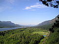
Columbia River Highway, including the notable 620-foot-high (190 m) Multnomah Falls. Trails and day use sites are maintained by the Forest Service and many...
17 KB (1,573 words) - 02:02, 21 October 2023

Crater Lake National Park (section Plaikni Falls)
park headquarters, 6,475 feet (1,974 m) above sea level, show that snow falls more often here than at any other long-term weather station in Oregon. Winter...
36 KB (3,721 words) - 07:22, 30 July 2024
List of named state highways in Oregon (redirect from Cline Falls Highway No. 373)
city limits — 01931-01-011931 current Cline Falls Highway No. 373 10.46 16.83 US 20 in Tumalo OR 126 at Cline Falls — 01933-01-011933 01978-01-011978 Tumalo–Deschutes...
93 KB (600 words) - 15:53, 11 May 2024
Golden and Silver Falls State Natural Area is a state park in Coos County, Oregon, United States, administered by the Oregon Parks and Recreation Department...
1 KB (78 words) - 22:16, 1 August 2023

just west of Redmond, Oregon. Here it passes by Eagle Crest Resort and Cline Falls State Scenic Viewpoint. As it heads north through the central Oregon...
25 KB (2,465 words) - 13:32, 28 January 2024

TouVelle Tub Springs Valley of the Rogue Wolf Creek Inn Central Oregon Cline Falls Cottonwood Canyon Deschutes River Dyer Elliott Corbett La Pine Ochoco...
15 KB (1,836 words) - 04:25, 14 January 2024

TouVelle Tub Springs Valley of the Rogue Wolf Creek Inn Central Oregon Cline Falls Cottonwood Canyon Deschutes River Dyer Elliott Corbett La Pine Ochoco...
16 KB (1,678 words) - 19:22, 4 August 2024

Butte Creek Falls, is a waterfall located on the south east of Scotts Mills, in Marion County, in the U.S. state of Oregon. It totals 78 feet fall in...
1 KB (62 words) - 16:07, 25 November 2023

TouVelle Tub Springs Valley of the Rogue Wolf Creek Inn Central Oregon Cline Falls Cottonwood Canyon Deschutes River Dyer Elliott Corbett La Pine Ochoco...
15 KB (1,786 words) - 15:35, 18 February 2024
April 20, 2017 (2017-04-20) 64 "Live At Revolution Hall" Bobby Jack Fowler Cline Falls axe attack April 13, 2017 (2017-04-13) Minisode "MFM Minisode 24" Stories...
173 KB (344 words) - 04:38, 6 July 2024

Prospect State Scenic Viewpoint (redirect from Mill Creek Falls Scenic Area)
Falls Scenic Area, a private hiking area that was developed by Willamette Industries along the Rogue River. Both Mill Creek Falls and Pearsony Falls are...
5 KB (452 words) - 01:29, 3 August 2023

Willamette National Forest (redirect from Erma Bell Falls)
TouVelle Tub Springs Valley of the Rogue Wolf Creek Inn Central Oregon Cline Falls Cottonwood Canyon Deschutes River Dyer Elliott Corbett La Pine Ochoco...
15 KB (1,647 words) - 05:13, 20 April 2024

TouVelle Tub Springs Valley of the Rogue Wolf Creek Inn Central Oregon Cline Falls Cottonwood Canyon Deschutes River Dyer Elliott Corbett La Pine Ochoco...
25 KB (2,930 words) - 12:56, 4 May 2024
TouVelle Tub Springs Valley of the Rogue Wolf Creek Inn Central Oregon Cline Falls Cottonwood Canyon Deschutes River Dyer Elliott Corbett La Pine Ochoco...
11 KB (1,025 words) - 19:44, 27 June 2024
Women's Forum viewpoint A closeup of the Heceta Head Light tower Silver Falls Smith Rock Whale watching center at Depoe Bay North of Cape Falcon in Oswald...
64 KB (470 words) - 17:26, 12 May 2024

Sherar's Falls, is a small waterfall along the Deschutes River shortly before emptying into the Columbia River. It is a place considered a sacred fishing...
4 KB (445 words) - 22:21, 5 May 2024

Annie Falls, is the tallest of three waterfalls so named, located along Annie Creek in the Crater Lake National Park at the south end of Rim Village Historic...
2 KB (167 words) - 04:48, 4 December 2023

TouVelle Tub Springs Valley of the Rogue Wolf Creek Inn Central Oregon Cline Falls Cottonwood Canyon Deschutes River Dyer Elliott Corbett La Pine Ochoco...
4 KB (387 words) - 16:22, 22 March 2024

TouVelle Tub Springs Valley of the Rogue Wolf Creek Inn Central Oregon Cline Falls Cottonwood Canyon Deschutes River Dyer Elliott Corbett La Pine Ochoco...
5 KB (425 words) - 15:57, 30 October 2023