
Cueva de los Tayos (redirect from Cueva de los Tayos de Coangos)
(1.2 mi) south of the Santiago River, and 800 metres (2,600 ft) west of Coangos River. The entrance to the cave has a vertical void of 70 meters and local...
20 KB (2,582 words) - 09:09, 2 October 2024
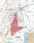
of the Cordillera del Cóndor, in Peru's land), and a larger outpost, "Coangos", on the high ground overlooking them from the north[1] (see map). In turn...
56 KB (7,329 words) - 00:21, 13 September 2024
(in Spanish). INRENA. pp. 12, 22–25, 38–40. "Coangos climate: Average Temperature, weather by month, Coangos weather averages – Climate-Data.org". en.climate-data...
6 KB (438 words) - 16:05, 4 September 2024
Projects Ecuador Cascabel Porvenir Rio Amarillo Sharug Cisne Loja Blanca Chical Cisne Victoria Coangos Helipuerto La Hueca Chillanes Timbara Salinas...
8 KB (655 words) - 05:40, 22 April 2024
down by Ecuadorian forces using a Blowpipe missile between Base Sur and Coangos, killing five. 7 February 1995 – A Peruvian Mil Mi-24 was shot down by...
219 KB (20,446 words) - 12:43, 8 October 2024

biologist had set foot in before, such as the Ijiach Naint hill in the Coangos River Basin. These recent field trips, carried out with the collaboration...
8 KB (833 words) - 22:02, 8 April 2024