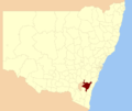
Corang is a locality in the Queanbeyan–Palerang Regional Council, New South Wales, Australia. It is located on the north side of the Corang River and...
3 KB (178 words) - 06:49, 17 May 2023
Corang River is a perennial river of the Shoalhaven catchment located in the Southern Tablelands region of New South Wales, Australia. Corang River rises...
3 KB (146 words) - 12:49, 13 November 2024
Coolongolook Coolumbooka Cooma Back Cooma Coopers Cooplacurripa Coorongooba Corang Cordeaux Corindi Cowriga Coxs Crawford Crookwell Crudine Cudgegong Culgoa...
84 KB (2,294 words) - 00:00, 11 November 2024
Industry and Environment (2023). Corang pine (Callitris oblonga subsp. corangensis) 2023 post-fire survey, Corang River. ISBN 978-1-923132-21-4 https://www...
3 KB (288 words) - 01:29, 20 February 2024
Council, New South Wales, Australia. It is located on the south side of the Corang River and to the east of the road from Braidwood to Nowra about 34 km north...
3 KB (132 words) - 03:34, 2 September 2023
Localities around Nerriga: Windellama Coolumburra Coolumburra Oallen Nerriga Sassafras Oallen Corang Endrick...
9 KB (724 words) - 08:40, 18 April 2024
The river is joined by thirty-four tributaries, including the Mongarlowe, Corang, Endrick, and Kangaroo rivers, and descends 864 metres (2,835 ft) over its...
15 KB (1,310 words) - 08:49, 12 October 2024
paces and on rocky creek banks from the southern Blue Mountains to the Corang River further south. "Leptospermum morrisonii". Australian Plant Census...
4 KB (400 words) - 17:24, 22 March 2021
Bombay Boro Budawang Burra Bywong Carwoola Captains Flat Charleys Forest Corang Currawang Durran Durra Farringdon Forbes Creek Harolds Cross Hereford Hall...
7 KB (450 words) - 11:17, 12 September 2024
of the national park. The area is also covered by the 1:25,000 CMA maps CORANG (8927-3-N), ENDRICK (8927-4-S), TIANJARA (8927-1-S) and MILTON (8927-2-N)...
13 KB (1,316 words) - 20:52, 10 March 2024
(Coolumburra Parish) Corang Queanbeyan-Palerang Regional Council 35°12′54″S 150°07′04″E / 35.21500°S 150.11778°E / -35.21500; 150.11778 (Corang Parish) Croobyar...
12 KB (248 words) - 06:59, 6 August 2024
Port Kembla Tasman Sea Shoalhaven River Kangaroo River Mongarlowe River Corang River Endrick River St Georges Basin Tasman Sea Clyde River Yadboro River...
21 KB (546 words) - 16:43, 19 December 2023
the coast and tablelands of New South Wales from the Blue Mountains to Corang. "Pultenaea divaricata". Australian Plant Census. Retrieved 7 July 2021...
3 KB (368 words) - 10:56, 8 July 2023
Cootralantra Public School Cootralantra Snowy Monaro 1893 1944 Corang River Public School Corang Queanbeyan–Palerang 1873 1920 Corunna Public School Corunna...
85 KB (444 words) - 01:20, 28 June 2024
Council New South Wales Coolumburra City of Shoalhaven New South Wales Corang Queanbeyan-Palerang Regional Council New South Wales Courabyra Snowy Valleys...
55 KB (1,686 words) - 04:44, 15 August 2024
32°59′54″S 150°20′04″E / 32.99833°S 150.33444°E / -32.99833; 150.33444 Corang Palerang 35°12′54″S 150°04′04″E / 35.21500°S 150.06778°E / -35.21500;...
30 KB (94 words) - 17:20, 26 December 2022
England Tablelands in northern New South Wales C. o. parva (K.D. Hill) – Corang River catchment in southern New South Wales Callitris oblonga is an evergreen...
4 KB (315 words) - 12:12, 8 November 2023
Bettowynd Bimberamala Bombala Brogo Buckenbowra Burrungubugge Clyde Coolumbooka Corang Delegate Deua Endrick Eucumbene Genoa Goobarragandra Gungarlin Imlay Ingeegoodbee...
4 KB (201 words) - 11:19, 8 June 2022
Bettowynd Bimberamala Bombala Brogo Buckenbowra Burrungubugge Clyde Coolumbooka Corang Delegate Deua Endrick Eucumbene Genoa Goobarragandra Gungarlin Imlay Ingeegoodbee...
4 KB (185 words) - 23:28, 27 April 2022


