
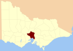
The County of Benambra is one of the 37 counties of Victoria which are part of the cadastral divisions of Australia, used for land titles. It is located...
3 KB (238 words) - 09:10, 7 May 2023

Bethanga, Victoria (category Shire of Towong)
Shire of Towong local government area, 390 kilometres (242 mi) from the state capital, Melbourne. At the 2016 census, Bethanga had a population of 471 and...
11 KB (1,114 words) - 09:41, 7 May 2023

called counties, which are further subdivided into parishes and townships, for cadastral or land administration purposes. Cadastral divisions of county, parish...
13 KB (1,092 words) - 17:24, 17 December 2023

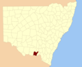
coordinates) Goulburn County is one of the 141 cadastral divisions of New South Wales. It contains the city of Albury, and the towns of Jindera, Bowna and...
7 KB (98 words) - 06:55, 6 August 2024

Research aids, Victoria 1910 Map of the counties of Benambra, Tambo, Croajingolong and Dargo in Victoria showing county boundaries, parish boundaries, main...
3 KB (223 words) - 09:10, 7 May 2023

Research aids, Victoria 1910 Map of the counties of Benambra, Tambo, Croajingolong and Dargo in Victoria showing county boundaries, parish boundaries, main...
4 KB (273 words) - 09:10, 7 May 2023

Wodonga (redirect from History of Wodonga)
district of Benambra. Bill Tilley of the Liberal Party has represented the electoral district of Benambra since the 2006 Victorian state election. Benambra has...
28 KB (2,811 words) - 12:33, 11 July 2024

on 15 January 1957, each of which elected three councillors: Omeo Riding Ensay Riding Hinnomunjie Riding Tongio Riding Benambra Brookville Cassilis Dinner...
4 KB (255 words) - 11:36, 12 May 2023

Mount Tambo (category Mountains of Victoria (state))
on the south-east slopes. It marks the intersection of the boundaries of the counties of Benambra, Dargo and Tambo. While travelling with Georg Neumayer's...
4 KB (274 words) - 02:19, 8 July 2024

The County of Bendigo is one of the 37 counties of Victoria which are part of the cadastral divisions of Australia, used for land titles. It includes the...
3 KB (224 words) - 09:10, 7 May 2023

The County of Gladstone is one of the 37 counties of Victoria which are part of the cadastral divisions of Australia, used for land titles. It is located...
3 KB (186 words) - 09:11, 7 May 2023

The County of Grant is one of the 37 counties of Victoria which are part of the cadastral divisions of Australia, used for land titles. It is located to...
4 KB (307 words) - 22:19, 20 March 2024

The County of Villiers is one of the 37 counties of Victoria which are part of the cadastral divisions of Australia, used for land titles. It includes...
3 KB (217 words) - 09:11, 7 May 2023

The County of Wonnangatta is one of the 37 counties of Victoria which are part of the cadastral divisions of Australia, used for land titles. It includes...
3 KB (201 words) - 15:00, 18 December 2023

The County of Ripon is one of the 37 counties of Victoria which are part of the cadastral divisions of Australia, used for land titles. The county includes...
3 KB (281 words) - 16:46, 21 May 2024
coordinates) Hume County is one of the 141 cadastral divisions of New South Wales. It contains the town of Culcairn. Hume County was named in honour of the explorer...
9 KB (90 words) - 12:26, 4 May 2023

The County of Polwarth is one of the 37 counties of Victoria which are part of the cadastral divisions of Australia, used for land titles. The county is...
2 KB (196 words) - 09:11, 7 May 2023

The County of Talbot is one of the 37 counties of Victoria which are part of the cadastral divisions of Australia, used for land titles. It is located...
3 KB (144 words) - 09:11, 7 May 2023

The County of Rodney is one of the 37 counties of Victoria which are part of the cadastral divisions of Australia, used for land titles. It is located...
3 KB (227 words) - 09:11, 7 May 2023

The County of Tambo is one of the 37 counties of Victoria which are part of the cadastral divisions of Australia, used for land titles. It is located in...
3 KB (215 words) - 09:11, 7 May 2023

The County of Bogong is one of the 37 counties of Victoria which are part of the cadastral divisions of Australia, used for land titles. It is located...
4 KB (315 words) - 09:10, 7 May 2023

The County of Grenville is one of the 37 counties of Victoria which are part of the cadastral divisions of Australia, used for land titles. It is located...
3 KB (213 words) - 09:11, 7 May 2023

The County of Mornington is one of the 37 counties of Victoria which are part of the cadastral divisions of Australia, used for land titles. It is located...
3 KB (201 words) - 02:46, 23 February 2024

The County of Buln Buln is one of the 37 counties of Victoria which are part of the cadastral divisions of Australia, used for land titles. It was first...
4 KB (377 words) - 09:10, 7 May 2023

The County of Delatite is one of the 37 counties of Victoria which are part of the cadastral divisions of Australia, used for land titles. It is located...
3 KB (214 words) - 09:10, 7 May 2023

County of Heytesbury is one of the 37 counties of Victoria which are part of the cadastral divisions of Australia, used for land titles. The county is...
2 KB (162 words) - 09:11, 7 May 2023

The County of Tatchera is one of the 37 counties of Victoria which are part of the cadastral divisions of Australia, used for land titles. It is located...
3 KB (251 words) - 09:11, 7 May 2023

The County of Evelyn is one of the 37 counties of Victoria which are part of the cadastral divisions of Australia, used for land titles. It is located...
3 KB (186 words) - 02:46, 23 February 2024

The County of Normanby in Victoria, is one of the 37 counties of Victoria which are part of the cadastral divisions of Australia, used for land titles...
3 KB (241 words) - 09:11, 7 May 2023
The County of Bourke is one of the 37 counties of Victoria which are part of the Lands administrative divisions of Australia, (used for land titles and...
20 KB (396 words) - 02:45, 23 February 2024