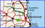
The D'Aguilar Highway is a two-lane highway linking the Bruce Highway near Caboolture with the Bunya Highway in Kingaroy in the state of Queensland, Australia...
22 KB (1,114 words) - 16:52, 25 July 2024
Expressway Burnett Highway D'Aguilar Highway New England Highway Isis Highway Scenic Highway (Queensland) Port of Brisbane Motorway Capricorn Highway Centenary...
5 KB (348 words) - 01:07, 25 July 2024

Brisbane Valley Highway is a state highway in Queensland, Australia. It links the Warrego Highway near Ipswich and the D'Aguilar Highway about 4 km (2 mi)...
13 KB (784 words) - 12:20, 15 July 2024

just south of Rockhampton, to the D'Aguilar Highway in Nanango. Its length is approximately 542 kilometres. The highway takes its name from the Burnett...
15 KB (930 words) - 06:03, 27 April 2024
D'Aguilar may refer to: Baron Diego Pereira D' Aguilar, Portuguese nobleman and Marrano. Ephraim Lópes Pereira d'Aguilar, 2nd Baron d'Aguilar Francis...
1 KB (154 words) - 16:48, 16 July 2014

Island interchange also provides access to the D'Aguilar Highway via a service road. After the D'Aguilar Highway interchange the Bruce passes through mainly...
103 KB (5,398 words) - 16:42, 25 July 2024

Stonehouse is a heritage-listed former homestead and inn on the D'Aguilar Highway, Moore, Somerset Region, Queensland, Australia. It was built from c...
16 KB (2,283 words) - 03:41, 15 September 2023

Bunya Highway: Dalby–Cooyar Road Macalister–Bell Road Kingaroy–Jandowae Road Bunya Mountains Road Kingaroy–Burrandowan Road D'Aguilar Highway Memerambi–Gordonbrook...
8 KB (448 words) - 02:42, 15 January 2024
Burpengary–Caboolture Road Caboolture Connection Road Caboolture–Bribie Island Road D'Aguilar Highway Pumicestone Road Glass House Mountains Road Bells Creek Arterial Road...
40 KB (3,348 words) - 15:45, 4 April 2024

of D'Aguilar had a population of 1,474 people, while the town of D'Aguilar had a population of 1,341 people. D'Aguilar lies on the D'Aguilar Highway between...
6 KB (440 words) - 16:52, 25 July 2024

Highway (National Route 17) from the D'Aguilar Highway to Esk, the New England Highway (State Route A3) from Hampton to Toowoomba, the Gore Highway (National...
7 KB (385 words) - 04:02, 21 July 2024

intersect with the highway are listed in the main article. At its northern end New England Highway connects to D'Aguilar Highway, and at its southern...
41 KB (2,888 words) - 17:00, 20 May 2024
to the west. The road ends at a T-junction with the D'Aguilar Highway (State Route 85) in D'Aguilar. Woodford is about 4-kilometre (2.5 mi) to the north-west...
19 KB (1,058 words) - 16:40, 25 July 2024
Highway, Queensland D'Aguilar Highway, Queensland Alberta Highway 17 Alberta Highway 17 (former) British Columbia Highway 17 British Columbia Highway...
10 KB (730 words) - 23:30, 4 April 2024
as a highway, but without a highway name. For example, Great Southern Highway is classified as a main road, not as a highway, or Hereward Highway in the...
24 KB (397 words) - 08:34, 6 June 2024
system still remain. All routes east of the Pacific Motorway (then Pacific Highway) and north of the Nerang River changed numbering. The changes made on the...
81 KB (670 words) - 20:26, 24 January 2024
regional significance (LRRS). The road runs from the D'Aguilar Highway in Kilcoy to the Bunya Highway in Murgon, a distance of 120 kilometres (75 mi). In...
4 KB (314 words) - 12:58, 23 May 2024

Highway 1 along either coast. Roads that make up the highway are: Great Central Road Gunbarrel Highway Lasseter Highway Stuart Highway Plenty Highway...
9 KB (315 words) - 05:03, 11 February 2024
Yimbun) southside, Links Brisbane Valley Highway to farms atand provides an alternate route to Kilcoy D'Aguilar Highway 26°56′39″S 152°21′33″E / 26.94417°S...
24 KB (1,137 words) - 11:16, 27 April 2024
approaches from the south. In addition to the New England Highway, D'Aguilar Highway and Bunya Highway, the following roads are considered to be part of the...
11 KB (882 words) - 16:42, 25 July 2024
maps. In addition to the Bruce Highway, the Captain Cook Highway, Cairns Western Arterial Road, and the Kennedy Highway, the network consists of the following...
6 KB (528 words) - 21:15, 5 April 2024
Royal Automobile Club of Queensland. Retrieved 17 July 2017. "Leichhardt Highway Melbourne to Rockhampton". Royal Automobile Club of Queensland. Retrieved...
40 KB (873 words) - 09:22, 2 June 2024

Great Dividing Range via the D'Aguilar Highway, easy highway access to Brisbane and the Sunshine Coast via the Bruce Highway, and the Caboolture–Bribie...
45 KB (4,532 words) - 03:55, 28 July 2024

3.5 kilometres (2.2 mi) east of Blackbutt and is by-passed by the D'Aguilar Highway. The Benarkin State Forest is located to the east and south of the...
11 KB (930 words) - 01:49, 13 June 2024

locality from north to south passing to the east of the town centre. The D'Aguilar Highway runs from the south to the north-west of the locality. The western...
13 KB (1,312 words) - 03:25, 6 June 2024

Gore Highway is a highway running between Toowoomba and Goondiwindi in Queensland, Australia. Together with Goulburn Valley Highway and Newell Highway, it...
12 KB (954 words) - 05:22, 14 June 2024
New England Highway state-controlled roads in Queensland presents information about how the Queensland segment of the New England Highway is described...
12 KB (1,052 words) - 01:05, 22 January 2024

The Capricorn Highway is located in Central Queensland, Australia, and links the city of Rockhampton with western Queensland. The highway is 575 kilometres...
18 KB (1,323 words) - 20:53, 18 May 2024

Leichhardt Highway is a major transport route in Queensland, Australia. It is a continuation northward from Goondiwindi of the Newell Highway, via a 2.0-kilometre...
9 KB (266 words) - 22:59, 27 May 2024
Road between Rocksberg on the Caboolture River and Wamuran on the D'Aguilar Highway. It is highly likely that the line of road from Alderley to Petrie...
28 KB (1,684 words) - 17:25, 5 April 2024