
estuary eventually empties into Storm Bay and the Tasman Sea. Historically, the banks of the Derwent were covered by forests and frequented by Aboriginal...
23 KB (2,027 words) - 16:44, 4 June 2024
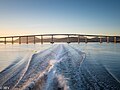
The Tasman Bridge is a prestressed concrete girder bridge connecting the Tasman Highway over the River Derwent in Hobart, Tasmania, Australia. When it...
29 KB (2,955 words) - 04:00, 23 June 2024
the south-east region of Tasmania, Australia. The bay is the river mouth to the Derwent River estuary and serves as the main port of Hobart, the capital...
2 KB (110 words) - 11:52, 3 May 2022

the Derwent River. The designation "Tasman Highway" arises from its location facing the Tasman Sea – named, like the state itself, after Abel Tasman. The...
25 KB (1,373 words) - 10:33, 19 May 2024

Ferries in Hobart (section Tasman Bridge disaster)
Sydney's Emerald-class ferry. Following the Tasman Bridge disaster in 1975, services across the Derwent River were operated by Sullivans Cove Ferry Services...
11 KB (1,060 words) - 04:00, 3 July 2024

estuaries of the Derwent and the Huon Rivers and empties into the Tasman Sea of the South Pacific Ocean. It was sighted by Abel Tasman in 1642 and surveyed...
8 KB (626 words) - 10:32, 8 January 2024
island, all rivers eventually empty into the waters that surround Tasmania. There are four main river systems: In the south, the Derwent flows from the...
14 KB (291 words) - 09:41, 31 August 2024
area has a population of 61,531, covering the eastern shore of the Derwent River from Otago to the South Arm Peninsula and the smaller localities of...
64 KB (7,091 words) - 13:29, 5 October 2024
Tasmanian wine (redirect from Tasman wine)
that is marked by the strong winds of the Indian Ocean, Bass Strait and Tasman Sea. These winds necessitate the use of large screens around the perimeter...
8 KB (998 words) - 14:32, 19 March 2024
for 628 nautical miles (1,163 km) through the Tasman Sea, Bass Strait, Storm Bay and up the River Derwent, to cross the finish line in Hobart, Tasmania...
8 KB (251 words) - 21:21, 1 April 2024

Royal Hobart Regatta (section Trans Derwent Swim)
Governor. Commencing adjacent Montagu Bay the Trans Derwent Swim sees competitors cross the Derwent River Estuary, a distance of 1.5km. In recent years a...
21 KB (887 words) - 01:24, 5 October 2024
service (either currently or previously) the River Derwent and surrounds (such as the Huon River, Tasman Peninsula, and D'Entrecasteaux Channel around...
11 KB (224 words) - 02:55, 7 July 2024
Illawarra crashes into Tasman Bridge, causing 12 deaths and bringing down part of bridge; temporary Bailey bridge put across Derwent 1975: Police academy...
67 KB (8,489 words) - 01:58, 9 September 2024

along the River Derwent in the Hobart suburb of Taroona, Australia. The south facing beach looks directly out to Storm Bay and the Tasman Sea, with views...
7 KB (590 words) - 04:05, 18 February 2024

Bowen Bridge (category River Derwent (Tasmania))
The Bowen Bridge is a segmental cantilever road bridge crossing the River Derwent in Tasmania, Australia. The bridge serves as a vital transportation...
11 KB (996 words) - 20:34, 19 September 2024

east coast lies within the Tasman Sea. Located to the island's northeast Storm Bay, is the river mouth to the Derwent River estuary, and serves as the...
23 KB (1,824 words) - 03:26, 19 October 2024
630 nautical miles (1,170 km) through the Tasman Sea, past Bass Strait, into Storm Bay and up the River Derwent, to cross the finish line in Hobart, Tasmania...
8 KB (163 words) - 03:23, 23 January 2024
630 nautical miles (1,170 km) through the Tasman Sea, past Bass Strait, into Storm Bay and up the River Derwent, to cross the finish line in Hobart, Tasmania...
8 KB (163 words) - 09:33, 22 January 2024

similar to the causeway section of the Bridgewater Bridge across the River Derwent. In recent years it has undergone massive repairs and modifications...
4 KB (322 words) - 13:23, 23 July 2024
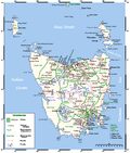
Tasman Council is a local government body in Tasmania, situated in the south-east of the state. Tasman is classified as a rural local government area and...
6 KB (375 words) - 01:57, 19 April 2024
630 nautical miles (1,170 km) through the Tasman Sea, past Bass Strait, into Storm Bay and up the River Derwent, to cross the finish line in Hobart, Tasmania...
6 KB (155 words) - 03:40, 26 January 2024
major crossing of the Derwent River near the location of the temporary Bailey bridge at Risdon Cove, 10 km to the north of the Tasman Bridge. With Federal...
102 KB (14,319 words) - 19:08, 14 August 2024

to the Derwent River estuary and the port of Hobart, the capital city of Tasmania. It is bordered by Bruny Island to the west and the Tasman Peninsula...
34 KB (4,058 words) - 16:43, 9 February 2024
630 nautical miles (1,170 km) through the Tasman Sea, past Bass Strait, into Storm Bay and up the River Derwent, to cross the finish line in Hobart, Tasmania...
6 KB (200 words) - 00:07, 20 January 2024
lost. 1975: Lake Illawarra, bulk carrier, sunk in the River Derwent, after colliding with the Tasman Bridge, 12 lives lost. 1979: Charleston (Yacht) disappeared...
20 KB (2,359 words) - 10:12, 7 July 2024

Hobart (category Populated places on the River Derwent)
Australia. Located in Tasmania's south-east on the estuary of the River Derwent, it is the southernmost capital city in Australia. Despite containing...
144 KB (12,974 words) - 01:24, 13 October 2024
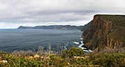
Cape Pillar (category Tasman National Park)
hydrographic service. Cape Pillar is a confirmed locality. The waters of the Tasman Sea form the western, southern and eastern boundaries. Route C344 (Fortescue...
5 KB (352 words) - 16:44, 25 July 2024
630 nautical miles (1,170 km) through the Tasman Sea, past Bass Strait, into Storm Bay and up the River Derwent, to cross the finish line in Hobart, Tasmania...
6 KB (157 words) - 09:34, 22 January 2024
dollar catamaran Condor II upon Blackjack Rock in the mouth of the Derwent River. He has won numerous design and manufacturing awards for his shipbuilding...
5 KB (507 words) - 11:01, 30 August 2024

operates cruises and charter routes on the Derwent River, Tasmania. These ferry tours have operated on the Derwent Harbour since the 1980s [citation needed]...
4 KB (206 words) - 09:13, 7 February 2024