
Deschutes County (/dəˈʃuːts/ də-SHOOTS) is one of the 36 counties in the U.S. state of Oregon. As of the 2020 census, the population was 198,253. The...
24 KB (2,231 words) - 03:31, 5 August 2024

The Deschutes River (/dəˈʃuːts/ də-SHOOTS) in central Oregon is a major tributary of the Columbia River. The river provides much of the drainage on the...
25 KB (2,465 words) - 13:32, 28 January 2024

Central Oregon and the county seat of Deschutes County, Oregon, United States. It is located to the east of the Cascade Range, on the Deschutes River....
70 KB (6,082 words) - 16:20, 31 July 2024
Deschutes River Woods is a census-designated place (CDP) and unincorporated community in Deschutes County, Oregon, United States. It is part of the Bend...
8 KB (650 words) - 13:04, 8 November 2023
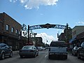
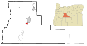
Redmond is a city in Deschutes County, Oregon, United States. The population was 33,274 at the 2020 census, and according to 2023 census estimates, the...
28 KB (2,373 words) - 02:44, 17 July 2024

300-acre (13 km2) planned residential and resort community in Deschutes County, Oregon, United States. As of the 2020 census it had a population of 2...
14 KB (672 words) - 22:22, 6 August 2024

Devils Lake is a lake located in Deschutes County, Oregon, along the Cascade Lakes Scenic Byway and found at an elevation of 5,446 feet (1,660 m). U.S...
2 KB (50 words) - 02:25, 19 September 2020

La Pine is a city in Deschutes County, Oregon, United States, incorporated on December 7, 2006. La Pine is part of the Bend, Oregon Metropolitan Statistical...
20 KB (2,061 words) - 05:15, 7 August 2024

south-central Deschutes County, south of Sunriver and north of La Pine, just west of U.S. Route 97. The Deschutes and Little Deschutes rivers join in...
8 KB (569 words) - 13:05, 8 November 2023

Three Sisters Wilderness at the boundary of Lane and Deschutes counties and the Willamette and Deschutes national forests, they are about 10 miles (16 kilometers)...
57 KB (6,281 words) - 02:25, 9 January 2024

Sisters is a city in Deschutes County, Oregon, United States. It is part of the Bend, Oregon Metropolitan Statistical Area. The population was 2,038 at...
18 KB (1,367 words) - 20:48, 23 July 2024

1984. Biden flipped two counties Trump won in 2016: Marion County, home to the state capital of Salem; and Deschutes County, anchored by fast-growing...
44 KB (1,111 words) - 04:10, 6 August 2024

Hampton is an unincorporated community in Deschutes County, Oregon, United States. It lies about 60 miles (97 km) southeast of Bend, on U.S. Route 20,...
4 KB (267 words) - 22:08, 25 July 2023
refer to: Deschutes County, Oregon, a county in the U.S. state of Oregon Deschutes National Forest, a national forest in Oregon Deschutes River, a river...
2 KB (265 words) - 21:24, 23 July 2023

community and census-designated place (CDP) in Deschutes County, Oregon, United States. It is part of the Bend, Oregon Metropolitan Statistical Area. The population...
8 KB (601 words) - 05:41, 14 July 2023

Cascade Lakes Scenic Byway (redirect from Oregon Highway 372)
Byway in central Oregon in the United States. It runs for 66 miles (106 km) in the rugged country of Deschutes and Klamath counties on the east side of...
5 KB (423 words) - 07:27, 13 August 2023
The Little Deschutes River is a tributary of the Deschutes River in the central part of the U.S. state of Oregon. It is about 105 miles (169 km) long...
7 KB (462 words) - 07:50, 23 July 2023

unincorporated community and census-designated place (CDP) in Deschutes County, Oregon, United States. As of the 2010 census it had a population of 488...
7 KB (359 words) - 18:12, 6 April 2024
community in Deschutes County, Oregon, United States. Plainview is located off of U.S. Route 20 several miles southeast of Sisters, Oregon. "Plainview"...
2 KB (49 words) - 18:43, 26 May 2019

Crane Prairie Reservoir (category Lakes of Deschutes County, Oregon)
Bend in Deschutes County, Oregon, United States. The reservoir is named for the cranes that thrive in its habitat and for the upper Deschutes River prairie...
4 KB (261 words) - 17:01, 28 February 2021

Creek Falls. Tumalo State Park List of waterfalls in Oregon "Bridge Creek Falls Deschutes County, Oregon". Northwest Waterfall Survey. Retrieved 6 May 2017...
2 KB (196 words) - 03:47, 28 July 2017

an unincorporated community in Deschutes County, Oregon, United States on U.S. Route 20. It is part of the Bend, Oregon Metropolitan Statistical Area....
13 KB (426 words) - 00:47, 17 July 2024

The Oregon Badlands Wilderness is a 29,301-acre (11,858 ha) wilderness area located east of Bend in Deschutes and Crook counties in the U.S. state of Oregon...
18 KB (1,651 words) - 02:14, 3 April 2024

CS1 maint: multiple names: authors list (link) "Atlas of Oregon Lakes: Elk Lake (Deschutes County)". Portland State University. 1985–2012. Retrieved January...
4 KB (338 words) - 13:55, 19 September 2021

unincorporated community in Deschutes County, Oregon, United States. It is located about five miles east of Sisters, on Oregon Route 126. In the late 19th...
6 KB (410 words) - 08:09, 14 December 2023

The Deschutes River flows north into the Columbia River. The South Fork Crooked River originates in an area called Misery Flat, along the Deschutes County...
19 KB (2,036 words) - 15:06, 7 December 2020

Union, Wallowa, Wasco, Wheeler counties, all but a small sliver of Jefferson County and the southeastern portions of Deschutes (excluding Bend and areas to...
34 KB (493 words) - 19:36, 5 August 2024
List of waterfalls in Oregon "Big Falls Deschutes County, Oregon". Northwest Waterfall Survey. Retrieved 8 June 2017. "Deschutes River - Canyon Run (Lower...
1 KB (89 words) - 01:42, 1 December 2019

census-designated place (CDP) and unincorporated private resort community in Deschutes County, Oregon, United States. It is located in the Cascade Range, 8 miles (13 km)...
8 KB (594 words) - 05:41, 21 June 2024

The Deschutes National Forest is a United States national forest (NF) located in Central Oregon, in parts of Deschutes, Klamath, Lake, and Jefferson counties...
13 KB (1,053 words) - 06:27, 17 April 2024