Devils Fork was an unincorporated community located in Wyoming and Raleigh counties, West Virginia, United States. Part of the community was renamed Stephenson...
3 KB (85 words) - 04:28, 24 July 2023
to North America The Devils Fork, a tributary of the Little Red River in Arkansas Devil Fork, Kentucky Devils Fork, West Virginia This disambiguation page...
486 bytes (96 words) - 08:36, 17 April 2013

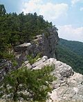
Devils Fork (conservation area), a wildland in the George Washington and Jefferson National Forests of western Virginia, has been recognized by the Wilderness...
9 KB (975 words) - 00:54, 10 February 2021

Matewan (/ˈmeɪtwɒn/) is a town in Mingo County, West Virginia, United States at the confluence of the Tug Fork River and Mate Creek. The population was 412...
13 KB (1,187 words) - 01:32, 18 November 2024

Fork Union, Virginia. Founded in 1898, Fork Union is considered one of the premier military boarding academies in the United States. Fork Union is a member...
35 KB (3,520 words) - 01:01, 21 December 2024
Devil's Den is on the Civil War battlefield at Gettysburg, Pennsylvania. Devil's Den may also refer to: Devil's Den State Park, in West Fork, Arkansas...
935 bytes (142 words) - 19:40, 25 November 2020
41529 (mouth of Devils Jump Branch) headwaters at 37°14′31″N 83°25′40″W / 37.24193°N 83.42779°W / 37.24193; -83.42779 (Devils Jump Branch headwaters)...
24 KB (3,317 words) - 22:42, 18 February 2024
Detroit River - Michigan Devils River - Michigan Devils River - Texas Devils River - Wisconsin Dillons Run - West Virginia Dirty Devil River - Utah Dix River...
4 KB (288 words) - 21:06, 13 November 2023

Guyandotte River (category Rivers of West Virginia)
three streams, Winding Gulf, Stonecoal Creek, and the Devils Fork. The Guyandotte flows initially west northwest into Wyoming and Mingo counties. It turns...
8 KB (524 words) - 07:35, 1 July 2024

385 feet (117 m) high and 1,750 feet (530 m) long. The lake is within Devils Fork State Park. Although most manmade structures were demolished before the...
12 KB (1,284 words) - 19:12, 30 October 2024

Hatfield–McCoy feud (category History of West Virginia)
families of the West Virginia–Kentucky area along the Tug Fork of the Big Sandy River from 1863 to 1891. The Hatfields of West Virginia were led by William...
60 KB (6,568 words) - 22:45, 22 December 2024

Trans-Allegheny Lunatic Asylum (redirect from West Virginia Hospital for the Insane)
the Virginia General Assembly. An appointed Board of Directors was tasked with the purchase of a pre-approved parcel of land near the West Fork River...
22 KB (2,140 words) - 21:02, 5 November 2024
eastern West Virginia. Kile Knob, at 4,588 feet (1,398 m), is the mountain's highest point, and Panther Knob and Pike Knob are nearly as high. North Fork Mountain...
28 KB (3,064 words) - 22:35, 20 September 2024

Cheat River (redirect from Forks of Cheat)
West Virginia, by the confluence of Shavers Fork and Black Fork. Black Fork is fed by the Blackwater River and by the Dry, Glady, and Laurel Forks —...
18 KB (1,717 words) - 23:54, 30 December 2024

Coal Wars (section West Virginia coal wars)
p. 18. Savage 1990. Green, James (2015-02-03). The Devil Is Here in These Hills: West Virginia's Coal Miners and Their Battle for Freedom. Open Road...
9 KB (958 words) - 16:35, 21 September 2024
It is in the Ash Fork School District. Lee Patton, legendary Hall of Fame coach at West Virginia University, former coach at Ash Fork High School. Adam...
14 KB (1,517 words) - 15:23, 24 September 2024
side of Tug Fork, a tributary of the Big Sandy River. During the almost thirty-year feud with the Hatfield clan under their patriarch Devil Anse Hatfield...
16 KB (1,900 words) - 14:02, 20 December 2024

unincorporated community in Wyoming County, West Virginia, United States. Part of the community was known as Devils Fork until 1935. The community was named after...
4 KB (100 words) - 02:12, 2 November 2023
Stone Mountain Wilderness (category Wilderness areas of Virginia)
Little Laurel Branch North Fork of the Pound Roaring Branch Little Stony Creek Devils Fork (conservation area) Laurel Fork (conservation area) List of...
8 KB (857 words) - 18:42, 6 August 2024

Virginia. Richmond, Virginia: Sierra Club Virginia Chapter. pp. 63–67. ISBN 978-0-926487-79-6. General Information: Wilderness.net - Lewis Fork Wilderness -...
9 KB (1,016 words) - 18:37, 6 August 2024

List of dams and reservoirs in the United States (redirect from List of dams and reservoirs in Virginia)
North Santiam River Dexter Reservoir and Dexter Dam – Middle Fork Willamette River Devils Lake – D River Dorena Reservoir - Row River Emigrant Lake – Emigrant...
41 KB (3,527 words) - 10:46, 27 July 2024

in the U.S. state of West Virginia. As of the 2020 census, the population was 23,093. Its county seat is Romney, West Virginia's oldest town (1762). The...
42 KB (3,907 words) - 00:45, 19 December 2024

his talents to Fork Union Military Academy, a prep school in Virginia just west of Richmond, and has become a leader of the Blue Devils' defense." "Marquis...
6 KB (508 words) - 00:34, 26 December 2024

Appalachian Development Highway System through Southwest Virginia. The U.S. Highway serves as the main east–west highway of Scott County and the primary north–south...
17 KB (1,139 words) - 14:47, 17 February 2024

by the shore of Devils Lake, a closed-capture lake which would spill into the Sheyenne River in an overflow condition. The North Fork Sheyenne River flows...
21 KB (1,279 words) - 15:52, 21 December 2024

U.S. Route 522 (redirect from U.S. Route 522 (West Virginia))
Route 522 (US 522) is a spur route of US 22 in the states of Virginia, West Virginia, Maryland, and Pennsylvania. The U.S. Highway travels in a north-south...
66 KB (5,529 words) - 19:27, 25 June 2024

Appalachians" (PDF). West Virginia University Department of Geology & Geography. Morgantown, West Virginia: West Virginia University – via West Virginia Geological...
35 KB (911 words) - 22:00, 20 February 2024
This is a complete list of placenames in Hampshire County, West Virginia. Placename entries are compiled from the United States Geological Survey's Geographic...
103 KB (26 words) - 10:26, 16 October 2024

George Washington and Jefferson National Forests (category National forests of West Virginia)
Wilderness Lewis Fork Wilderness Little Dry Run Wilderness Little Wilson Creek Wilderness Mountain Lake Wilderness (Virginia / West Virginia) Peters Mountain...
28 KB (1,816 words) - 01:10, 8 October 2024

There are 37 state parks in the U.S. state of West Virginia as of 2017[update]. The West Virginia Division of Natural Resources (WVDNR) Parks and Recreation...
139 KB (8,004 words) - 20:10, 24 October 2024