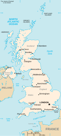
Dryhill is a small hamlet in the Sevenoaks district, in the county of Kent, England. It is about two miles away from the large town of Sevenoaks, located...
3 KB (195 words) - 18:01, 23 August 2022
Middle Fork Kentucky River (redirect from Dryhill, Kentucky)
Kaliopi after Sam's mother (c.f. Calliope). It closed in July 1981. The Dryhill post office was established on 1897-09-30 by postmaster Dan McDaniel. It...
24 KB (3,317 words) - 22:42, 18 February 2024
Dryhill is an 11.7-hectare (29-acre) geological Site of Special Scientific Interest on the western outskirts of Sevenoaks in Kent. It is a Geological...
3 KB (181 words) - 13:09, 31 March 2023
Dry Hill and Dryhill may refer to: Dryhill, village in Kent Dry Hill, nature preserve in Massachusetts Dry Hill, Illinois, an unincorporated community...
290 bytes (69 words) - 09:17, 11 May 2021
Natural ragstone outcrop in Dryhill Nature Reserve near Sevenoaks, Kent...
2 KB (279 words) - 03:59, 2 October 2023
subject to extensive seasonal flooding. One part of the town is called 'Dryhill'. Richard Fitz Gilbert de Clare founded the Priory of St Mary Magdalene...
43 KB (4,562 words) - 20:55, 29 October 2024
Albian 125–110 Ma PreꞒ Ꞓ O S D C P T J K Pg N Lower Greensand outcrop near Dryhill Type Stratigraphic group Sub-units Wessex Basin: Atherfield Clay Formation...
7 KB (786 words) - 08:12, 21 August 2024
centuries, so much so that the higher part of the town to the north is called "Dryhill". Flood protection measures have therefore been taken. In 1981, a flood...
27 KB (2,780 words) - 10:29, 31 August 2024
(6 km) to the Hal Rogers Parkway at Thousandsticks. Kentucky Route 257 (Dryhill Road) is a local road that leads north from Hyden down the valley of the...
12 KB (1,202 words) - 00:57, 21 August 2024
The Roderick McIntosh Farm, near Dryhill, Kentucky, dates from 1816. It was listed on the National Register of Historic Places in 1991. It has also been...
2 KB (97 words) - 02:16, 15 November 2022
205833°N 83.336944°W / 37.205833; -83.336944 (Roderick McIntosh Farm) Dryhill 3 John Shell Cabin November 12, 1975 (#75000791) South of Chappell on Greasy...
3 KB (383 words) - 09:05, 6 March 2022
River. KY 257 heads north along Dryhill Road, which crosses Rockhouse Creek and follows the left bank of the river. At Dryhill, the highway meets the east...
91 KB (9,054 words) - 18:30, 9 May 2024
1517772". Research records (formerly PastScape). Dryhill Crickley Hill SO93161688 Historic England. "Dryhill Villa (117453)". Research records (formerly PastScape)...
78 KB (369 words) - 17:40, 26 September 2024
Quarry". Local Nature Reserves. Natural England. Retrieved 5 March 2018. "Dryhill (Aptian-Albian)". Geological Conservation Review. Joint Nature Conservation...
72 KB (1,883 words) - 00:56, 20 September 2024
Dunes and Gullery, Ravenglass Lake District Drinkfield Marsh Darlington Dryhill Kent Duffield Millennium Meadow Duffield, Derbyshire Duke's Hollow London...
118 KB (96 words) - 11:44, 14 August 2024
judge of Leslie County. He is buried in Napier-Sizemore-Begley Cemetery, Dryhill, Kentucky. Cpt Nathaniel B. Skinner (1835–1879), Company B, 28th Kentucky...
76 KB (3,153 words) - 03:29, 21 May 2024
east – Hazard Southern end of KY 80 concurrency 49.619 79.854 KY 257 north (Dryhill Road) Southern terminus of KY 257 50.140 80.693 KY 118 west Eastern terminus...
31 KB (696 words) - 16:31, 14 November 2024
Rockholds KY 779 near Perkins KY 3424 Thousandsticks KY 257 in Dryhill KY 3425 Dryhill KY 3426 KY 80 near Wendover Toulouse KY 3427 KY 699 near Big Rock...
72 KB (29 words) - 05:59, 12 July 2024
Dryhill". Sites of Special Scientific Interest. Natural England. Archived from the original on 3 February 2018. Retrieved 2 February 2018. "Dryhill (Aptian-Albian)"...
234 KB (7,792 words) - 18:37, 13 August 2024
84861; -4.31000 Dryhill Cross T junction Stoodleigh, Mid Devon 50°57′49″N 3°31′45″W / 50.9637°N 3.5291°W / 50.9637; -3.5291 ("Dryhill Cross") Named...
11 KB (115 words) - 03:59, 16 December 2023
Hill Hampshire 51°07′N 1°04′W / 51.11°N 01.07°W / 51.11; -01.07 SU6536 Dryhill Kent 51°16′N 0°08′E / 51.27°N 00.13°E / 51.27; 00.13 TQ4955 Dryhope...
35 KB (26 words) - 05:15, 14 March 2022


