Komárom-Esztergom (Hungarian: Komárom-Esztergom vármegye, pronounced [ˈkomaːrom ˈɛstɛrɡom]; German: Komitat Komorn-Gran; Slovak: Komárňansko-ostrihomská...
19 KB (1,147 words) - 20:59, 6 July 2024

Dunaszentmiklós (German: Niklo) is a village in Komárom-Esztergom County, Hungary. Street map (Hungarian) v t e...
1 KB (17 words) - 23:07, 13 July 2024

"Komárom-Esztergom megye parlamenti képviselői (Parlamenti Információs Rendszer 2018-2022)" (in Hungarian). Hungarian National Assembly. "Komárom-Esztergom...
7 KB (257 words) - 18:29, 19 July 2022

Tata District (category Districts in Komárom-Esztergom County)
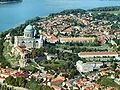
Tata (Hungarian: Tatai járás) is a district in northern part of Komárom-Esztergom County. Tata is also the name of the town where the district seat is...
5 KB (302 words) - 01:12, 29 July 2023

Duna-Gerecse Area (category Geography of Komárom-Esztergom County)
The Duna-Gerecse area is located in Hungary on the territory of the Komárom-Esztergom County on the right side of the Danube at the Slovakian border. The...
5 KB (669 words) - 14:17, 21 August 2024
Kalocsai 955 6333 Dunaszentgyörgy V Tolna Paksi 2,661 7135 Dunaszentmiklós V Komárom-Esztergom Tatai 423 2897 Dunaszentpál V Gyor-Moson-Sopron Gyori 646...
9 KB (69 words) - 15:50, 11 February 2024