
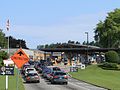
Emigrant Gap is a gap in a ridge on the California Trail as it crosses the Sierra Nevada, to the west of what is now known as Donner Pass. Here the cliffs...
8 KB (370 words) - 04:51, 7 July 2023

Emigrant Gap (formerly, Wilsons Ranch) is an unincorporated community in Placer County, California. The Emigrant Gap community is located 0.25 miles (0...
7 KB (191 words) - 03:49, 19 July 2024

Interstate 80 in California (redirect from Auburn-Emigrant Gap State Highway)
Dutch Flat and Donner Lake Wagon Road from Emigrant Gap to Donner Lake. The segment of I-80 from Emigrant Gap to Truckee also forms part of the Yuba–Donner...
69 KB (4,647 words) - 18:27, 25 August 2024
Canyon–Nyack Airport (IATA: BLU, ICAO: KBLU, FAA LID: BLU) is an airport in Emigrant Gap, Placer County, California. The airport is served by a single asphalt...
3 KB (165 words) - 05:00, 24 January 2023
maintains two schools, one in Alta, California and one in Emigrant Gap, California. Emigrant Gap Elementary School District was consolidated with Alta-Dutch...
3 KB (259 words) - 00:03, 17 March 2022

California Trail (redirect from Mormon Emigrant Trail)
The California Trail was an emigrant trail of about 1,600 mi (2,600 km) across the western half of the North American continent from Missouri River towns...
214 KB (31,610 words) - 14:27, 24 July 2024
California Emigrant Gap, a California Trail crossing on the west Sierra slope near the Emigrant Gap, California community named for the crossing Emigrant, for...
1 KB (196 words) - 06:38, 8 November 2015

Clear Lake, Colusa, Yuba City, Marysville and Nevada City to I-80 near Emigrant Gap, where eastbound traffic can continue on other routes to Lake Tahoe or...
27 KB (2,326 words) - 10:43, 15 September 2024

side of the mountain, along the Bear River below the steep approach to Emigrant Gap, perhaps starving but alive. When they arrived in the river valley, they...
91 KB (12,937 words) - 08:14, 29 September 2024
California. It consists of the following routes: Interstate 80 from Emigrant Gap to Truckee California State Route 89 from Truckee to Sierraville California...
1 KB (133 words) - 01:18, 19 September 2019

appropriation for the location, survey and construction of a state highway from Emigrant Gap...to the west end of Donner Lake...", approved March 13, 1909, chapter...
44 KB (3,526 words) - 02:01, 22 February 2024

incident. In 1986, the Placer County Sheriff's Office located a skull near Emigrant Gap along California State Route 20 in the Sierra Nevada, 70 miles from South...
174 KB (18,994 words) - 13:34, 4 October 2024

Washington Alta Applegate Auburn Carnelian Bay Colfax Dollar Point Dutch Flat Emigrant Gap Foresthill Gold Run, California Homewood Kings Beach Meadow Vista Sheridan...
17 KB (770 words) - 05:21, 12 July 2024
County, California. Cisco Grove is located 7 miles (11.3 km) east of Emigrant Gap. It lies at an elevation of 5643 feet (1720 m). U.S. Geological Survey...
2 KB (76 words) - 16:43, 22 December 2023

River due to elevated levels of mercury. The Bear River originates at Emigrant Gap, as a tiny stream on the border of Nevada and Placer Counties in the...
21 KB (1,979 words) - 10:26, 1 October 2023
4784000°W / 49.0011000; -114.4784000 Whiskey Gap Emigrant Gap Road Alberta Emigrant Gap Emigrant Gap Road The Canadian port was originally called Fareham...
115 KB (1,288 words) - 23:40, 5 October 2024
Creek Airport Death Valley National Park L09 Stovepipe Wells Airport Emigrant Gap BLU BLU KBLU Blue Canyon - Nyack Airport Eureka O33 Eureka Municipal...
57 KB (648 words) - 07:01, 9 September 2024

and descend a high ridge between the American and Yuba Rivers, through Emigrant Gap. The line empties out into the California Central Valley, and then runs...
36 KB (2,441 words) - 06:07, 4 October 2024

single track 7.1-mile (11.4 km) section between Switch 9 (MP 171.9) at Emigrant Gap and Shed 10 (MP 179.0) west of Cisco would likely also have to be restored...
21 KB (2,125 words) - 08:14, 28 May 2024
County, California. Blue Canyon is located 4 miles (6.4 km) southwest of Emigrant Gap. It lies at an elevation of 4695 feet (1431 m). Blue Canyon was possibly...
9 KB (529 words) - 19:29, 28 August 2024

the route for the railroad over the Sierra Nevada through Clipper Gap and Emigrant Gap, over Donner Pass, and south to Truckee. They discovered a way across...
144 KB (18,839 words) - 14:10, 30 September 2024

at Casper would come to favor a route through a small valley called Emigrant Gap which headed directly to Rock Avenue, bypassing Red Buttes. Upon arrival...
25 KB (3,220 words) - 17:36, 22 September 2023
Cranfills Gap is a city located in Bosque County in central Texas, United States. It was founded by Norwegian Emigrants and to this day most residents...
11 KB (1,203 words) - 22:01, 16 August 2024

Sunnyside-Tahoe City Tahoe Vista Tahoma Applegate Baxter Blue Canyon Emigrant Gap Northstar Ophir Olympic Valley Weimar Iowa Hill The population ranking...
61 KB (2,642 words) - 19:13, 28 August 2024
Tulare Fresno Merced Modesto Stockton San Francisco Sacramento Colfax Emigrant Gap Blyth Arena The Olympic flame arrived at Los Angeles International Airport...
22 KB (2,082 words) - 00:35, 3 August 2024
Belmar / Farmingdale, New Jersey KBLU – Blue Canyon-Nyack Airport – Emigrant Gap, California KBLV (BLV) – MidAmerica St. Louis Airport / Scott Air Force...
177 KB (15,598 words) - 17:00, 1 October 2024
in Fort Bragg to SR 16 near Rumsey SR 49 in Grass Valley to I-80 near Emigrant Gap Part of the Yuba-Donner Scenic Byway (also a National Forest Scenic Byway)...
56 KB (4,303 words) - 07:05, 20 June 2024
Rocks Rd and various other mountain roads parallelling I-80 through Emigrant Gap, Magra, Colfax, Weimar, Applegate, and Auburn. The route then continued...
36 KB (4,824 words) - 21:53, 12 September 2024

is signed as a state highway. This route is broken into pieces due to a gap in the description, unfilled by any route. "Route Renumbering: New Green...
106 KB (856 words) - 02:21, 22 May 2024
Queensland, Australia UTC+10:00 BLU KBLU Blue Canyon–Nyack Airport Emigrant Gap, California, United States UTC−08:00 Mar-Nov BLV KBLV MidAmerica St....
90 KB (376 words) - 17:54, 22 September 2024