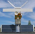
European Remote Sensing satellite (ERS) was the European Space Agency's first Earth-observing satellite programme using a polar orbit. It consisted of...
9 KB (1,003 words) - 04:37, 3 July 2024

remote sensing (when a signal is emitted by a satellite or aircraft to the object and its reflection is detected by the sensor) and "passive" remote sensing...
63 KB (7,739 words) - 02:49, 7 July 2024

observation satellite or Earth remote sensing satellite is a satellite used or designed for Earth observation (EO) from orbit, including spy satellites and similar...
14 KB (1,586 words) - 03:29, 31 July 2024
European Space Agency mission), European Remote Sensing Satellite 1 and 2 (ERS 1/ERS 2), the Japanese Earth Resources Satellite 1 (JERS 1), RADARSAT 1 and...
19 KB (1,881 words) - 07:56, 19 May 2024
at that location. Remote sensing in oceanography mostly refers to measuring properties of the ocean surface with sensors on satellites or planes, which...
33 KB (4,474 words) - 01:32, 30 April 2024
Remote sensing is used in the geological sciences as a data acquisition method complementary to field observation, because it allows mapping of geological...
62 KB (7,081 words) - 03:56, 24 June 2024

Water Remote Sensing is the observation of water bodies such as lakes, oceans, and rivers from a distance in order to describe their color, state of ecosystem...
10 KB (1,143 words) - 05:43, 17 February 2024

as for the International Cospas-Sarsat Programme and the European Remote-Sensing Satellite. TSS became part of NSC in 1990, although it was partially...
18 KB (2,216 words) - 23:20, 8 May 2024
National Remote Sensing Centre (Hindi: राष्ट्रीय सुदूर संवेदन केन्द्र), or NRSC, located in Hyderabad, Telangana is one of the centres of the Indian Space...
2 KB (99 words) - 16:37, 29 May 2024

and system validation. Satellites include European Remote-Sensing Satellite 2, Sentinel 1, 2, 3 and 5P and Envisat. The European Organisation for the Exploitation...
29 KB (3,024 words) - 11:22, 4 August 2024

photography Earth observation satellite Moderate-resolution imaging spectroradiometer Reconnaissance satellite Remote sensing Shuttle Radar Topography Mission...
27 KB (3,139 words) - 19:44, 2 August 2024

Digital elevation model (section Satellite mapping)
stereoscopic correlation. Later, further data were provided by the European Remote-Sensing Satellite (ERS, 1991) using the same method, the Shuttle Radar Topography...
30 KB (3,235 words) - 10:40, 4 July 2024

Air pollution measurement (section Remote monitoring)
ozone levels from the ESA European Remote Sensing Satellite (ERS-2) in 1995, and NASA's MAPS (Mapping Pollution with Satellites), which measured the distribution...
39 KB (3,787 words) - 20:26, 4 January 2024

Space-based radar (redirect from Earth-observing radar satellite)
Geosat (altimeter, United States, 1985-1990) ERS-1 and ERS-2 (European Remote-Sensing Satellite) (altimeter, combined SAR/scatterometer, 1991-2011) RADARSAT-1...
10 KB (1,334 words) - 06:50, 28 July 2024

Ocean color (section Ocean color remote sensing)
developed alongside water remote sensing, so it is focused mainly on how color is measured by instruments (like the sensors on satellites and airplanes). Most...
41 KB (4,274 words) - 02:16, 4 June 2024
Ethnobotany Ethylmercury EU energy label EU-Eco-regulation European Remote-Sensing Satellite EuroVelo Eutrophication EverLife Flashlight E-waste Exhaust...
40 KB (3,771 words) - 00:36, 7 July 2024
Copernicus Programme (redirect from Sentinel (satellite))
European Space Agency (ESA), the European Organisation for the Exploitation of Meteorological Satellites (EUMETSAT), the European Centre for Medium-Range Weather...
42 KB (4,677 words) - 14:03, 9 July 2024

Egyptsat1 (MisrSat 1) Spaceports Around the World: Iraq's Al-Anbar Space Research Center Military Intelligence Satellites (NASA, remote sensing tutorial)...
15 KB (1,472 words) - 21:46, 31 July 2024
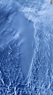
Subglacial lake (section Satellite exploration)
lakes. In the early 1990s, radar altimeter data from the European Remote-Sensing Satellite (ERS-1) provided detailed mapping of Antarctica through 82...
86 KB (9,886 words) - 07:59, 25 May 2024

The Bangladesh Space Research and Remote Sensing Organization (Bengali: বাংলাদেশ মহাকাশ গবেষণা ও দূর অনুধাবন প্রতিষ্ঠান, romanized: Bangladesh mohakash...
5 KB (442 words) - 09:46, 14 April 2024

ice-penetrating radar survey and detected a possible lake. In 1991, the European remote sensing satellite ERS-1 confirmed the 1973 discovery of a large lake below four...
9 KB (834 words) - 15:44, 30 October 2023
Matra Marconi Space (section Satellites)
Esrange site of the Swedish Space Corporation Radar for the European Remote-Sensing Satellite (ERS-1) Altitude and orbit-control system for XMM-Newton,...
8 KB (688 words) - 08:44, 22 May 2023

Dornier Museum Friedrichshafen (section Satellites)
Ulysses – First inter-planetary probe to the poles of the sun, European Remote-Sensing Satellite At Night Aircraft on display in the main exhibition hall Do24...
4 KB (273 words) - 03:56, 13 February 2024
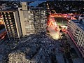
Distinct from possible construction defects, an analysis of European Remote-Sensing Satellite data by Florida International University indicates that the...
152 KB (12,769 words) - 01:56, 23 July 2024

Topography (section Remote sensing)
stages in map production resolve. As with field notes, remote sensing data (aerial and satellite photography, for example), is raw and uninterpreted. It...
16 KB (1,983 words) - 02:36, 16 June 2024

Globalstar satellite telephony services and Orbcomm messaging service in LEO, the Disaster Monitoring Constellation and RapidEye for remote sensing in Sun-synchronous...
25 KB (1,803 words) - 04:54, 31 July 2024

analysis of data from four different research satellite systems (Envisat, European Remote-Sensing Satellite, GRACE and GRACE-FO and ICESat) indicated annual...
36 KB (10,096 words) - 18:53, 27 July 2024
Scatterometer (category Satellite meteorology)
system operating at Ku-band (14 GHz). In 1991 ESA launched the European Remote-Sensing Satellite ERS-1 Advanced Microwave Instrument (AMI) scatterometer, followed...
11 KB (1,449 words) - 04:53, 8 June 2024

Sea level rise (section Satellites)
analysis of data from four different research satellite systems (Envisat, European Remote-Sensing Satellite, GRACE and GRACE-FO and ICESat) indicated annual...
214 KB (22,527 words) - 13:52, 7 August 2024

form of active remote sensing – the antenna transmits radiation that is reflected from the image area, as opposed to passive sensing, where the reflection...
39 KB (4,690 words) - 03:38, 29 July 2024