
✓ The source code of this SVG is valid....
(145 × 54 (4 KB)) - 22:05, 8 August 2024

DescriptionCouverture satellite inmarsat.svg Français : Couverture satellite inmarsat English: Inmarsat satellite coverage Date 05/11/2006 Source http://commons...
(702 × 647 (70 KB)) - 02:44, 23 April 2024

File:Satellite coverage.jpg (category Inmarsat)
Couverture satellite inmarsat I, the copyright holder of this work, hereby publish it under the following licenses: This file is licensed under the Creative...
(329 × 329 (39 KB)) - 05:51, 10 April 2021

DescriptionInmarsat-3 satellite outline.svg English: An Inmarsat-3 satellite. Date 2 December 2014 Source Own work (Derivative work: traced from File:Inmarsat-3...
(378 × 262 (7 KB)) - 05:06, 10 June 2022

DescriptionInmarsat-3.gif Deutsch: Weltraumfunkstelle (INMARSAT-3) Mobiler Seefunkdienst über Satelliten. English: INMARSAR-3 . Date 11 October 2008 Source...
(378 × 262 (20 KB)) - 16:55, 10 June 2023

DescriptionInmarsat ground earth station.svg English: SVG sketch of a ground earth station that is part of the Inmarsat satellite communication network...
(1,238 × 1,408 (20 KB)) - 09:01, 30 September 2020

NASA (Cropped from Inmarsat-3.gif) Author NASA Permission (Reusing this file) Other versions Derivative works: GIF file SVG color SVG outline (rotated 180°)...
(365 × 240 (47 KB)) - 05:06, 10 June 2022
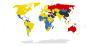
Somalia has to be set unknown Connectivity almost always by satellite only: Inmarsat, Iridium and Thuraya - all more or less censored. See EU, USA and Sharja...
(940 × 477 (1.56 MB)) - 02:38, 27 May 2023

DescriptionInmarsat3.svg Français : Satellite Inmarsat-3 English: An Inmarsat-3 satellite Date 5 November 2006 (upload date) Source Derivative work of File:Inmarsat-3.gif...
(341 × 220 (9 KB)) - 05:06, 10 June 2022

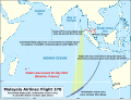
DescriptionFlight MH370 last ping corridors.svg English: Corridors where an Inmarsat satellite is calculated to have received the last ACARS signal from...
(709 × 500 (206 KB)) - 04:00, 23 October 2021

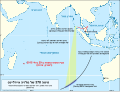
DescriptionFlight MH370 last ping corridors alt.svg English: Corridors where an Inmarsat satellite is calculated to have received the last ACARS signal...
(709 × 500 (418 KB)) - 04:00, 23 October 2021

communications between Malaysia Airlines Flight 370 and a ground station, via an Inmarsat-3 F1 satellite. The upper drawing shows the relation of the BTO measurement...
(652 × 652 (19 KB)) - 23:04, 13 December 2023

corridors & satellite location: Malaysia Department of Civil Aviation/Inmarsat Backgrounds: TPL & seafloor sonar survey: Whiteway, T., 2009. Australian...
(5,020 × 4,387 (8.55 MB)) - 05:41, 29 July 2024

file: Inmarsat ground earth station.svg. This vector image includes elements that have been taken or adapted from this file: Radio Mast Icon.svg. This...
(512 × 298 (92 KB)) - 20:02, 5 September 2020
yellow; based on analysis of communications between Flight 370 and the Inmarsat satellite communications network), and the underwater search area at the...
(3,900 × 2,963 (1.39 MB)) - 21:25, 5 January 2021

corridors & satellite location: Malaysia Department of Civil Aviation/Inmarsat Backgrounds: TPL & seafloor sonar survey: Whiteway, T., 2009. Australian...
(5,020 × 4,387 (8.53 MB)) - 11:22, 3 January 2021
yellow; based on analysis of communications between Flight 370 and the Inmarsat satellite communications network), and the underwater search area at the...
(3,900 × 2,963 (1.63 MB)) - 15:40, 23 October 2021

yellow; based on analysis of communications between Flight 370 and the Inmarsat satellite communications network), and the underwater search area at the...
(6,067 × 4,608 (2.07 MB)) - 10:28, 5 September 2020

communications between Malaysia Airlines Flight 370 and a ground station, via an Inmarsat-3 F1 satellite. The upper drawing shows the relation of the BTO measurement...
(3,622 × 3,622 (461 KB)) - 23:04, 13 December 2023