
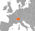
The Fläscherberg (also known as Regitzer Spitz) is a mountain of the Rätikon, overlooking the Rhine in the Swiss canton of Graubünden. The closest locality...
1 KB (59 words) - 21:05, 4 February 2023
on the Rhine, but also in the Rätikon range of the Alps, between the Fläscherberg and the Naafkopf. After the dissolution of Austria-Hungary in 1918, the...
16 KB (1,551 words) - 21:53, 8 September 2024
the Alpine chain, which belong to the Limestone Alps, two inselbergs, Fläscherberg (1,135 m or 3,724 ft above sea level) in the south and Eschnerberg (698 m...
106 KB (9,933 words) - 19:47, 25 September 2024

the Alpine chain, which belong to the Limestone Alps, two inselbergs, Fläscherberg (1135 meters above sea level.) in the south and Eschnerberg (698 m) in...
44 KB (4,913 words) - 16:16, 18 September 2024

33833°N 9.17500°E / 47.33833; 9.17500 Appenzell Alps St. Gallen 435 247 Fläscherberg (Regitzer Spitz) 1,135 3,724 422 1,385 47°02′15″N 09°30′23″E / 47.03750°N...
112 KB (1,337 words) - 21:15, 20 July 2024

Chur. At Landquart it turns north-east and then to the north around the Fläscherberg, east of Sargans. Near Sargans a natural dam, only a few metres high...
22 KB (2,419 words) - 23:21, 23 August 2024

municipality in the canton of Graubünden. Fläsch is located at the foot of the Fläscherberg and St. Luzisteig mountains. Fläsch has a population (as of 31 December...
8 KB (761 words) - 03:24, 21 July 2024

/ 46.95500°N 9.77500°E / 46.95500; 9.77500 Rätikon Prättigau-Davos Fläscherberg (Regitzer Spitz) 1135 422 47°02′15″N 09°30′23″E / 47.03750°N 9.50639°E...
27 KB (336 words) - 16:08, 5 May 2024
foraminifera fossils. From Dogger to Malm, in the Ultrahelvetic realm the Flascherberg is assembled from limestone and black shale. Geologists divide the Northern...
2 KB (303 words) - 09:02, 14 July 2024