
The Fort Pitt Incline was a 10 ft (3,048 mm) gauge funicular railroad in the Bluff neighborhood of Pittsburgh. Opened in 1882, the incline ran from 2nd...
3 KB (177 words) - 11:46, 15 March 2022
Fort Pitt Bridge Fort Pitt Elementary School Fort Pitt Foundry, historic armory Fort Pitt Hornets, former ice hockey team Fort Pitt Incline, former funicular...
1 KB (185 words) - 18:42, 30 March 2023

Duquesne Incline) to Water St. (now Fort Pitt Blvd.), near the tip of Point State Park. The Point Bridge closed two days after the opening of the Fort Pitt Bridge...
8 KB (621 words) - 05:00, 26 April 2024
operational) Fort Pitt Incline (1882–1900) H.B. Hays and Brothers Coal Railroad, inclines on Becks Run and Streets Run, operational in 1877 Knoxville Incline (1890–1960)...
68 KB (5,244 words) - 18:10, 13 October 2024
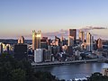
the inclines business declined and most were closed and removed. The Monongahela Incline, the first built in the city, and the Duquesne Incline are the...
6 KB (166 words) - 11:00, 7 April 2022

from the original on 25 June 2016. Retrieved 1 June 2016. "History of the Incline Railway". Archived from the original on 20 June 2016. Retrieved 1 June...
68 KB (1,924 words) - 04:07, 18 October 2024

Johnstown Inclined Plane (redirect from Johnstown Incline)
Diescher, who had also designed the Duquesne, Castle Shannon and Fort Pitt Inclines in Pittsburgh. The funicular consists of a parallel set of 8 ft (2...
23 KB (2,501 words) - 00:23, 17 August 2024
exceeds 2,200. Downtown Bridges Fort Pitt Bridge carries I-376 (Previously I-279) between Downtown and the Fort Pitt Tunnel Fort Duquesne Bridge carries I-279...
24 KB (2,175 words) - 18:49, 11 July 2024

tunnel. The Liberty Tunnel through Mount Washington opened in 1928. The Fort Pitt Tunnel beneath and through Mount Washington opened September 1, 1960....
7 KB (880 words) - 22:19, 1 October 2024
Samuel Diescher (category Railway inclines in Pittsburgh)
include the Castle Shannon Incline, the Castle Shannon South Incline, Penn Incline, Fort Pitt Incline, Troy Hill Incline (more probably designed by Gustav...
8 KB (779 words) - 02:34, 13 December 2023

cables holding it in place. The new Point Bridge was constructed by the Fort Pitt Bridge Works of Canonsburg, Pennsylvania and was situated closer to the...
5 KB (457 words) - 00:35, 17 October 2023

River by the Twenty Second Street Incline, which ran from Josephine Street to Salisbury Street, near the location of Fort McKinley. Arlington Heights has...
6 KB (277 words) - 17:26, 12 October 2023

Pittsburgh (redirect from Fort du Quesne)
finally took the forks in 1758. He began construction on Fort Pitt, named after William Pitt the Elder, while the settlement was named "Pittsborough"...
233 KB (22,926 words) - 22:17, 16 October 2024

County. The southern entrance to Downtown is through the Fort Pitt Tunnel and then over the Fort Pitt Bridge. The Panhandle Bridge, a former railroad bridge...
26 KB (2,868 words) - 02:29, 28 July 2024
Keeling Coal Company (category Railway inclines in Pittsburgh)
Page and Captain Phillips. The mine was served by a gravity plane, or incline, built between 1838 and 1844. It was operated by Doctor Oliver Harrison...
9 KB (799 words) - 18:51, 20 September 2024
Pitt ends 1764 The Fort Pitt Blockhouse is completed. 1768 November 5: Fort Pitt is annexed into Pennsylvania with the signing of the Treaty of Fort Stanwix...
71 KB (6,735 words) - 16:48, 24 September 2024

Ormsby in 1763, in recognition for his assistance in the building of Fort Pitt. By the 1770s, Ormsby had built an estate on these lands and established...
21 KB (1,947 words) - 11:28, 1 May 2024
Photograph (1855) showing the construction of the Bhor Ghaut incline bridge, Bombay; the incline was conceived by George Clark, the Chief Engineer in the...
144 KB (16,875 words) - 04:16, 1 October 2024

residents wanted tunnels to be built in Shalerville. Later in 1959, the Fort Pitt Tunnels were constructed very near this proposed area. Similarly, other...
9 KB (948 words) - 00:18, 10 January 2024

the bottom of the logo is representative of the bastions of Fort Duquesne and Fort Pitt, which were once located in the area now known as Point State...
23 KB (2,554 words) - 03:40, 20 August 2024

Park through Castlereagh, Bligh, and Loftus Streets to Fort Macquarie, returning through Pitt-street, and certain works in connection therewith ; and...
120 KB (15,881 words) - 14:04, 19 October 2024

has a peculiarity—it is the neatest town that the sun shines on; and I incline to believe that it is also the cleanest." On 7 September 1936, one of the...
144 KB (12,974 words) - 01:24, 13 October 2024
7, 2023. "Victory on Sugar Hill". Time. December 17, 1945. "Wright v. Incline Vill. Gen. Improvement Dist". Case Text. Retrieved May 7, 2023. Watts 2005a...
71 KB (7,410 words) - 23:11, 18 October 2024
Engineering Record. Retrieved 27 January 2014. "Panhandle Tunnel - Bridges and Tunnels of Allegheny County and Pittsburgh, PA". "Castle Shannon Inclines"....
5 KB (53 words) - 09:42, 7 September 2023

from the summit and the 38 slopes and trails with provide a variety of inclines. It is 13.2 miles southwest of Canadiagua. Within the City of Canandaigua...
34 KB (2,899 words) - 02:19, 18 October 2024
Tramways, ascend from Chino Canyon two and a half miles (4 km) up a steep incline to the station at 8,516 feet (2,596 m). The San Jacinto Wilderness is accessible...
159 KB (15,695 words) - 12:14, 2 October 2024
December 9, 2018. ""Grand Central Station" August 11, 1976, by Carolyn Pitts" (PDF). National Register of Historic Places Inventory-Nomination. National...
252 KB (21,853 words) - 14:52, 4 October 2024

the Penn Avenue business corridor and provide an easy way to access the Fort Pitt Playground and neighborhood parklets. Like nearby Bloomfield and Friendship...
12 KB (1,236 words) - 17:23, 31 March 2024
the pull truck failed to release the train and it stopped on the initial incline for about ten minutes. While operators were attempting to restart the ride...
311 KB (32,296 words) - 18:42, 17 October 2024

Local 27 Pittsburgh Fire Fighters IAFF Local 1 Fraternal Order of Police Fort Pitt Lodge No. 1 Christina Hartman became the first Democrat to officially...
58 KB (4,107 words) - 00:03, 17 September 2024