The Fort Smith Highway, officially Northwest Territories Highway 5, is a highway in Canada's Northwest Territories. Completed in 1966, the highway travels...
2 KB (135 words) - 21:25, 2 July 2024
Fort Smith (Chipewyan: Thebacha "beside the rapids") is a town in the South Slave Region of the Northwest Territories (NWT), Canada. It is located in the...
42 KB (3,088 words) - 20:57, 18 July 2024
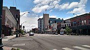
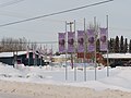
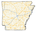
Fort Smith is the third-most populous city in Arkansas, United States, and one of the two county seats of Sebastian County. As of the 2020 census, the...
60 KB (6,111 words) - 00:56, 24 August 2024

Interstate 540 (Arkansas) (redirect from Arkansas Highway 540)
state of Arkansas in Fort Smith. The total length is 14.7 miles (23.7 km). At first, I-540 was a short spur connecting Fort Smith and Van Buren to I-40...
13 KB (1,266 words) - 15:29, 3 June 2024
The Fort Resolution Highway, officially Northwest Territories Highway 6, is a highway following the shore of Great Slave Lake from the Buffalo River Junction...
2 KB (134 words) - 07:16, 7 January 2024

the Bighorn River where it exits from Bighorn Canyon. Montana Highway 313 ends at Fort Smith and leads northeast 42 miles (68 km) to Hardin and Interstate...
12 KB (646 words) - 20:36, 1 August 2024
all-weather highway network are: Behchoko (Rae-Edzo) Dettah Enterprise Fort Liard Fort McPherson Fort Providence Fort Resolution Fort Simpson Fort Smith Hay River...
13 KB (216 words) - 19:55, 2 July 2024

U.S. Route 271 (redirect from United States Highway 271)
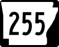
State Highway 31 and SH 155. The highway's northern terminus is in Fort Smith, Arkansas, at an intersection with Business U.S. Route 71 and Highway 255...
24 KB (1,146 words) - 02:03, 23 May 2024

Interstate 49 in Arkansas (redirect from Arkansas Highway 549 (Fort Smith))
into Missouri. An additional small section south of Fort Smith is currently designated as Highway 549 (AR 549) until it is extended northward to the I-40...
41 KB (2,850 words) - 01:00, 29 August 2024
Territories border at Northwest Territories Highway 5 (Fort Smith Highway) in Fort Smith, through the Smith Landing first nation, Pine Lake road which...
5 KB (484 words) - 05:36, 27 August 2024

south 14 miles (23 km) to Fayetteville and 69 miles (111 km) to Fort Smith. Highway 264 is a main east-west road in Lowell, connecting I-49 and US 71B...
14 KB (1,211 words) - 16:33, 21 April 2024

U.S. Route 71 in Arkansas (redirect from U.S. Highway 71 (Texas))
U.S. Highway 71 (US 71) is a U.S. highway that runs from Krotz Springs, LA to the Fort Frances–International Falls International Bridge at the Canadian...
41 KB (3,028 words) - 23:09, 16 August 2024

Trail, the highway is one of the original 1926 state highways. It is designated by the AHTD as the True Grit Trail. The route begins in Fort Smith at US 64/US 71B...
19 KB (1,415 words) - 05:31, 14 September 2023
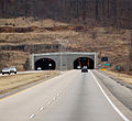
traffic remotely at the Fort Smith highway department district headquarters. The tunnel was named for the director of the Arkansas Highway Commission (a resident...
6 KB (524 words) - 17:59, 2 July 2024
of Fort Chaffee. The route has a junction with Highway 253 shortly before entering Fort Smith. Continuing west along the southern edge of Fort Smith Regional...
8 KB (552 words) - 03:03, 26 April 2024

Oklahoma, and ends at the Arkansas state line near Fort Smith, Arkansas. State Highway 9 is a major highway around the Norman area. At 348.1 miles (560.2 km)...
25 KB (1,681 words) - 16:40, 2 October 2023
Slave Lake to Yellowknife, and then west to Fort Simpson. The highway is one of the most "ruralized" highways in the N.W.T., with two subdivisions and one...
2 KB (140 words) - 17:10, 22 December 2022

The Highway of Tears is a 719-kilometre (447 mi) corridor of Highway 16 between Prince George and Prince Rupert in British Columbia, Canada, which has...
137 KB (6,679 words) - 12:00, 8 August 2024
region along the Alaska Highway at Mile 300. The town is approximately a four hour drive from the nearest urban centre, Fort St. John, but could potentially...
45 KB (4,008 words) - 15:50, 25 June 2024

the county seat of Crawford County. Highway 59 parallels US 59 (in Oklahoma) between Siloam Springs and Fort Smith. Since US 59 goes through Arkansas,...
13 KB (632 words) - 16:28, 16 February 2024
Fort Chaffee is just outside Fort Smith (Sebastian County) and Barling (Sebastian County) on Arkansas Highway 22, 1 mi (1.6 km) southeast of Fort Smith...
20 KB (2,236 words) - 08:41, 12 July 2024

collapse, the closure of highways 63 and 881, and the evacuation of 150 people. On May 3, 2016, a large wildfire burning southwest of Fort McMurray resulted...
50 KB (4,400 words) - 13:45, 27 July 2024
U.S. Route 71 (redirect from United States Highway 71)
Interstate highways. Currently, the highway's northern terminus is in International Falls, Minnesota at the Canada–US border, at the southern end of the Fort...
33 KB (3,488 words) - 01:41, 21 June 2024

C. Highway 97 intersects with B.C. Highway 77; the Pan-American Highway continues along B.C. 97 east to Fort Nelson. From Fort Nelson, the Highway travels...
71 KB (8,734 words) - 15:58, 29 August 2024
on the shores of Great Slave Lake, and at the end of the Fort Resolution Highway (Highway 6). It is the headquarters of the Deninu Kųę́ First Nation...
18 KB (1,283 words) - 16:55, 16 August 2024

(43 mph). The Highway 15/28A/28/63 corridor between Edmonton and Fort McMurray is considered one of Alberta's most important intraprovincial highways. It is...
157 KB (1,030 words) - 08:02, 28 August 2024
Queen Elizabeth Way (redirect from Ontario Provincial Highway 451)
Bridge in Fort Erie and travels 139.1 kilometres (86.4 mi) around the western end of Lake Ontario, ending at Highway 427 as the physical highway continues...
101 KB (9,257 words) - 23:23, 24 August 2024

Highway 34 State Highway 52 State Highway 144 Fort Morgan is the boyhood home of Big Band musician Glenn Miller. Miller went to high school in Fort Morgan...
21 KB (1,381 words) - 04:05, 14 August 2024
and passing through Fort Smith, Muskogee, Tulsa, Dodge City, La Junta and Pueblo. It was named after Albert Pike. Albert Pike Highway Association (1919)...
1 KB (92 words) - 09:48, 8 August 2024
Rural Roads Dangerous". Fort Smith Times-Record. Fort Smith. Retrieved July 4, 2020 – via NewsBank. "[Arkansas] State Highways 2009 (Database)." April...
244 KB (1,779 words) - 09:22, 17 August 2024