identity. Although Chadian society is economically, socially, and culturally fragmented, the country's geography is unified by the Lake Chad Basin. Once a...
38 KB (3,403 words) - 05:21, 27 October 2024
Chad, officially the Republic of Chad, is a landlocked country located at the crossroads of North and Central Africa. It is bordered by Libya to the north...
133 KB (11,501 words) - 01:46, 24 December 2024
Wildlife of Chad Fauna of Chad Birds of Chad Mammals of Chad Glaciers in Chad: none Lakes of Chad Mountains of Chad Volcanoes in Chad Rivers of Chad World Heritage...
13 KB (933 words) - 20:54, 17 August 2024
The Chad Basin is the largest endorheic basin in Africa, centered approximately on Lake Chad. It has no outlet to the sea and contains large areas of semi-arid...
25 KB (3,039 words) - 11:59, 2 October 2024
Geological Atlas of Africa, s.v. "The Comoros", 2008:74. Wikimedia Commons has media related to Geography of Mayotte. Wikimedia Atlas of Mayotte 12°50′S...
3 KB (237 words) - 14:36, 15 September 2024
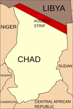
Aouzou Strip (category Geography of Chad)
is a strip of land in northern Chad that lies along the border with Libya, extending south to a depth of about 100 kilometers into Chad's Borkou, Ennedi...
7 KB (783 words) - 20:20, 25 October 2024
to Chad's petroleum industry including but not limited to corruption, internal conflict, and geography. Since Chad is landlocked, most of Chad's oil...
19 KB (2,252 words) - 09:35, 15 August 2024
Lake Chad (Arabic: بحيرة تشاد, Kanuri: Sádǝ, French: Lac Tchad) is an endorheic freshwater lake located at the junction of four countries: Nigeria, Niger...
41 KB (4,692 words) - 21:41, 22 December 2024
This is a list of renamed places in Chad Faya → Largeau → Faya-Largeau (1960) Fort-Foureau → Kousséri Fort-Lamy → N'Djamena (1973) Fort-Archambault →...
764 bytes (38 words) - 12:45, 5 March 2023
Sudan (region) (redirect from The Land of the Blacks)
Sudan is the geographical region to the south of the Sahara, stretching from Western Africa to Central and Eastern Africa. The name derives from the Arabic...
5 KB (451 words) - 17:25, 19 December 2024
Chad was divided into 14 prefectures from 1960, the year of independence, to 1999, when the country was divided in 28 departments. A further reorganisation...
2 KB (38 words) - 12:57, 29 June 2024
provided as an overview of and topical guide to geography: Geography – study of Earth and its people. an academic discipline – a body of knowledge given to...
86 KB (7,679 words) - 11:24, 25 November 2024
Sudanian savanna (category Geography of Chad)
province into three distinct physiographic sections, the Niger Basin, the Lake Chad Basin, and the Middle Nile Basin. The World Wide Fund for Nature divides...
15 KB (1,197 words) - 16:37, 3 July 2024
Piracy Problem." (2012). "Geography of Seychelles - Archive - Seychelles Nation". www.nation.sc. Retrieved 2020-05-26. "Geography of Seychelles | Mauritius...
32 KB (2,004 words) - 02:16, 15 November 2024
The Republic of Chad is divided into 23 regions. Chad was divided into regions in 2002. It was previously divided into prefectures, and then departments...
14 KB (401 words) - 03:28, 30 June 2024
لينيا) is a town in Chad, lying 30km east of N'Djamena. It is known for its large market. Chad, Post Report. United States Department of State. April 1986...
4 KB (51 words) - 19:36, 6 November 2024
in Chad, the capital of the Lac Region. The town is served by Bol Airport (IATA: OTC, ICAO: FTTL), which has a paved runway. Bol was on the shores of Lake...
7 KB (128 words) - 11:27, 3 November 2024
Chad (died 2 March 672) was a prominent 7th-century Anglo-Saxon monk. He was an abbot, Bishop of the Northumbrians and then Bishop of the Mercians and...
42 KB (5,697 words) - 05:06, 16 November 2024
N'Djamena (redirect from Capital of Chad)
largest city of Chad. It is also a special statute region, divided into 10 districts or arrondissements. The city serves as the centre of economic activity...
31 KB (2,326 words) - 03:42, 10 December 2024
of Chad Category:Impact craters of Chad Category:Departments of Chad Category:Chad geography stubs Category:Subdivisions of Chad Category:Regions of Chad...
23 KB (2,476 words) - 09:27, 9 July 2024
This is a list of cities and towns in Chad. In brackets there is the Arabic name of the city. Abéché (أبشي) Abou-Deïa (أبو ديا) Adé (أدي) Adré (أدري) Am...
3 KB (219 words) - 10:02, 24 April 2024
Ismailia 27°00′N 30°00′E / 27.000°N 30.000°E / 27.000; 30.000 The geography of Egypt relates to two regions: North Africa and West Asia. Egypt has coastlines...
20 KB (2,860 words) - 13:37, 4 December 2024
the Gulf of Guinea in the south and it borders Lake Chad to the northeast. Notable geographical features in Nigeria include the Adamawa Plateau, Mambilla...
56 KB (3,775 words) - 18:53, 6 December 2024
East Saharan montane xeric woodlands (category Geography of Chad)
The ecoregion covers the higher elevations of the Ennedi Plateau and the Ouaddaï Highlands of eastern Chad and the extinct volcano system Jebel Marra...
4 KB (353 words) - 01:23, 13 May 2024
"Island Countries Of The World". WorldAtlas.com. Archived from the original on 2017-12-07. Retrieved 2019-08-10. "Madagascar-GEOGRAPHY". countrystudies...
30 KB (2,871 words) - 21:15, 9 November 2024
at the geographic coordinates 26°30′S 31°30′E / 26.500°S 31.500°E / -26.500; 31.500. Eswatini has an area of 17,363 square kilometres, of which 160...
8 KB (492 words) - 20:32, 12 June 2024
Emi Koussi (category Calderas of Chad)
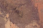
Emi Koussi seen from Apollo 7 in October 1968 Geography of Chad List of volcanoes in Chad List of Ultras of Africa "Emi Koussi". Global Volcanism Program...
26 KB (3,041 words) - 20:36, 11 September 2024
Tibesti–Jebel Uweinat montane xeric woodlands (category Geography of Chad)
ecoregion occupies two separate highland regions, covering portions of northern Chad, southwestern Egypt, southern Libya, and northwestern Sudan. The ecoregion...
5 KB (507 words) - 01:07, 19 May 2024
in Chad on the banks of the Chari River, near Sarh. It is the largest of only three villages where Laal is spoken. "PeopleGroups.org - Gori of Chad". peoplegroups...
591 bytes (60 words) - 13:52, 7 November 2024
West of Lake Chad is the basin of the Niger, the third major river of Africa. With its principal source in the far west, it reverses the direction of flow...
37 KB (4,495 words) - 18:41, 20 November 2024


