
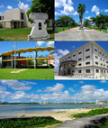
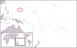
Guam is a U.S. territory in the western Pacific Ocean, at the boundary of the Philippine Sea. It is the southernmost and largest member of the Mariana...
26 KB (2,638 words) - 02:54, 21 August 2024

the geographic center of the U.S. In Oceania, Guam is the largest and southernmost of the Mariana Islands and the largest island in Micronesia. As of 2022...
107 KB (9,960 words) - 17:52, 9 September 2024
Mammals of Guam Beaches in Guam Islands of Guam Lakes of Guam Mountains of Guam Volcanoes in Guam Rivers of Guam Waterfalls of Guam Valleys of Guam World...
15 KB (1,355 words) - 11:40, 7 January 2024
coastal village and the capital of the United States territory of Guam. From the 18th through mid-20th century, it was Guam's population center, but today...
22 KB (1,705 words) - 10:06, 6 August 2024

taking of that village after World War II. List of census-designated places in Guam List of villages in the Northern Mariana Islands Geography of Guam Village...
8 KB (440 words) - 17:42, 19 February 2024
Guam Environment of Guam commons:Category:Environment of Guam Fanohge Chamoru (Stand Ye Guamanians) Flag of Guam Geography of Guam Category:Geography...
8 KB (806 words) - 00:48, 21 January 2023

off the southern tip of the United States territory of Guam, located within the Merizo Barrier Reef, part of the municipality of Malesso'. The island...
9 KB (597 words) - 11:53, 4 April 2024

The Battle of Guam (21 July – 10 August 1944) was the American recapture of the Japanese-held island of Guam, a U.S. territory in the Mariana Islands...
25 KB (2,624 words) - 01:44, 7 September 2024

Mariana Islands (redirect from History of the Mariana Islands)
at the southern end of the chain, the territory of Guam. The islands were named after the influential Spanish queen Mariana of Austria following their...
38 KB (4,134 words) - 03:30, 29 August 2024

Mount Lamlam (category Guam geography stubs)
Survey, United States Department of the Interior. "Mount Lamlam". MountainZone.com One internet site Geography of Guam claims the difference is 37,820...
3 KB (175 words) - 12:26, 28 October 2023
Alaska, Hawaii, the five insular territories of Puerto Rico, Northern Mariana Islands, U.S. Virgin Islands, Guam, American Samoa, and minor outlying possessions...
49 KB (5,624 words) - 23:03, 18 July 2024
Pacific coast (category Coastal geography)
Island Geography of the Cook Islands Geography of Easter Island Geography of Fiji Geography of French Polynesia Geography of Guam Geography of Hawaii...
4 KB (461 words) - 07:59, 16 January 2024

(Australia) Geography of Easter Island (Chile) Geography of Fiji Geography of French Polynesia (France) Geography of Guam (United States) Geography of Hawaii(United...
40 KB (3,405 words) - 15:39, 11 August 2024

provided as an overview of and topical guide to geography: Geography – study of Earth and its people. an academic discipline – a body of knowledge given to...
86 KB (7,702 words) - 22:50, 9 September 2024

Talofofo Falls (category Geography of Guam)
Talofofo Falls are a scenic series of cascades on the Ugum River on the island of Guam. They are located in the southeast of the island, inland from Talofofo...
735 bytes (88 words) - 23:59, 2 September 2024

geology of Guam formed as a result of mafic, felsic and intermediate composition volcanic rocks erupting below the ocean, building up the base of the island...
8 KB (1,145 words) - 08:47, 14 July 2024

The Capture of Guam was a bloodless engagement between the United States and Spain during the Spanish–American War. The U.S. Navy sent a single cruiser...
19 KB (2,392 words) - 14:58, 21 June 2024
The history of Guam starts with the early arrival around 2000 BC of Austronesian people known today as the Chamorro Peoples. The Chamorus then developed...
53 KB (6,105 words) - 08:42, 30 August 2024
This is a list of geographic centers of each U.S. state and inhabited territory. The geographic center of the United States is northeast of Belle Fourche...
32 KB (1,053 words) - 22:40, 25 August 2024
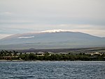
Mauna Kea (category Volcanoes of the Island of Hawaii)
World's Tallest Mountain?". wisegeek. August 9, 2023. "Geography of Guam". Government of Guam. Archived from the original on April 12, 2020. Retrieved...
105 KB (10,394 words) - 16:39, 5 September 2024
ISO 3166-2:GU (category Geography of Guam)
ISO 3166-2:GU is the entry for Guam in ISO 3166-2, part of the ISO 3166 standard published by the International Organization for Standardization (ISO)...
1 KB (114 words) - 03:15, 24 June 2023
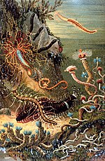
Polychaete (category CS1 maint: DOI inactive as of September 2024)
Archived 1996-10-27 at the Wayback Machine Geography of the ocean floor near Guam with some notes on exploration of the Challenger Deep. A tiny worm sheds...
31 KB (3,265 words) - 02:33, 12 September 2024

Guam rail (Hypotaenidia owstoni), known locally and in Chamorro as ko'ko', is a small, terrestrial bird in the Rallidae family. They are endemic of the...
22 KB (2,582 words) - 02:53, 8 September 2024

Andersen Air Force Base (redirect from North Field, Guam)
Air Force base located primarily within the village of Yigo in the United States territory of Guam. The host unit at Andersen AFB is the 36th Wing (36...
45 KB (4,534 words) - 11:12, 30 August 2024

of the United States: Puerto Rico, Guam, the U.S. Virgin Islands, American Samoa, and the Northern Mariana Islands. As of April 1, 2010, the date of the...
48 KB (1,323 words) - 11:24, 3 September 2024

located on the western shore of the United States territory of Guam. The village of Tamuning is the economic center of Guam, containing tourist center Tumon...
20 KB (1,346 words) - 14:07, 9 August 2024
Agrigan (category Geography of Guam)
Agrigan is a small island off the southern coast of the island of Guam. It is connected to the mainland by the Merizo Barrier Reef. Bendure, G. & Friary...
574 bytes (61 words) - 23:39, 14 September 2024
Fofos (category Geography of Guam)
southern coast of the island of Guam. It is connected to the mainland by the Merizo Barrier Reef. Cocos Lagoon List of rivers of Guam National Centers...
4 KB (119 words) - 18:26, 9 April 2023

original on December 27, 2011, retrieved October 20, 2011 "Guam | History, Geography, & Points of Interest". Encyclopedia Britannica. Archived from the original...
175 KB (14,439 words) - 19:46, 10 September 2024
The United States has control over fourteen territories. Five of them (American Samoa, Guam, the Northern Mariana Islands, Puerto Rico, and the United States...
42 KB (1,921 words) - 14:18, 4 September 2024