
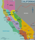
San Gorgonio Mountain, also known locally as Mount San Gorgonio, or Old Greyback, is the highest peak in Southern California and the Transverse Ranges...
13 KB (1,201 words) - 16:10, 6 September 2024
San Gorgonio is Spanish for "Saint Gorgonius"; San Gorgonio might also refer to: San Gorgonio Mountain, California, United States San Gorgonio Pass, California...
2 KB (209 words) - 00:32, 22 October 2022

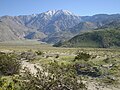
The San Gorgonio Wilderness is located in the eastern San Bernardino Mountains, in San Bernardino County and into northern Riverside County, Southern California...
5 KB (320 words) - 00:24, 1 November 2021
Beaumont, California (redirect from San Gorgonio, California)
States, located at the summit of the San Gorgonio Pass, between the San Bernardino Mountains and Mount San Gorgonio to the north, and the San Jacinto Mountains...
41 KB (3,451 words) - 14:20, 4 October 2024
Coachella Valley–San Gorgonio Pass Rail Corridor Service is an effort by the Riverside County Transportation Commission (RCTC) to start regular passenger...
8 KB (622 words) - 16:34, 11 December 2023

The San Gorgonio Pass, or Banning Pass, is a 2,600 ft (790 m) elevation gap on the rim of the Great Basin between the San Bernardino Mountains to the north...
10 KB (958 words) - 14:24, 12 September 2024

The San Gorgonio Pass wind farm is a wind farm that stretches from the eastern slope of the San Gorgonio Pass, near Cabazon, to North Palm Springs, on...
17 KB (1,940 words) - 20:02, 12 October 2024
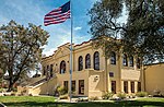
The San Gorgonio Inn was Banning, California's first hotel and was built by George W. Bryant and C. W. Filkins. Originally called the Bryant House, it...
2 KB (282 words) - 21:36, 23 March 2020
San Gorgonio High School is a comprehensive senior high school in the San Bernardino City Unified School District. Its campus is located at the corner...
4 KB (250 words) - 22:10, 29 August 2024
San Jacinto Peak (category San Gorgonio Pass)
the range and the county, and serves as the southern border of the San Gorgonio Pass. Naturalist John Muir wrote of San Jacinto Peak, "The view from San...
14 KB (1,342 words) - 02:28, 25 July 2024
he would spend overnight. On the trail towards the summit of Mount San Gorgonio, Negrete had trouble keeping up with the other scouts due to lack of experience...
5 KB (473 words) - 13:44, 13 October 2024
Rancho San Gorgonio, or San Gorgonio Rancho, might refer to; Rancho San Gorgonio, a cattle ranch established in the San Gorgonio pass in 1824 by the San...
615 bytes (94 words) - 23:24, 4 October 2020
048-meter) snowy mountaintop ridge, in the eastern portion of the San Gorgonio Wilderness, killing all aboard. Dolly Sinatra was 80 years old. It was...
11 KB (1,209 words) - 18:52, 7 October 2024
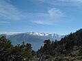
California counties, the range tops out at 11,503 feet (3,506 m) at San Gorgonio Mountain – the tallest peak in Southern California. The San Bernardinos...
43 KB (4,659 words) - 16:10, 22 October 2023
068 m). Further afield, the highest point in southern California is San Gorgonio Mountain, 81 miles (130 km) east of downtown Los Angeles, with a height...
248 KB (20,641 words) - 10:09, 20 October 2024
Robert J. Frankel Stakes (redirect from San Gorgonio Handicap)
California, known as San Gorgonio Pass, San Gorgonio Mountain. a mountain in the San Bernardino Mountains and the former town of San Gorgonio now called Beaumont...
40 KB (1,944 words) - 15:04, 17 February 2024
The San Gorgonio River is a 26.8-mile-long (43.1 km) river primarily flowing in western Riverside County, with a small upstream section in southwestern...
2 KB (239 words) - 01:50, 7 July 2023

census, down from 29,603 at the 2010 census. It is situated in the San Gorgonio Pass, also known as Banning Pass. It is named for Phineas Banning, stagecoach...
33 KB (3,135 words) - 14:19, 4 October 2024

The valley extends approximately 45 mi (72 km) southeast from the San Gorgonio Pass to the northern shore of the Salton Sea and the neighboring Imperial...
94 KB (10,495 words) - 03:39, 19 October 2024

the Mojave Desert. California's wind farms include Altamont Pass, San Gorgonio Pass, and Tehachapi Pass. The Tehachapi area is also where the Tehachapi...
275 KB (23,808 words) - 22:01, 16 October 2024
San Bernardino Downtown San Bernardino Chino Valley Perris Valley San Gorgonio Pass San Bernardino Mountains San Jacinto Mountains Temecula Valley San...
6 KB (377 words) - 04:44, 5 May 2024

Coachella and Victor Valleys, respectively on the other sides of the San Gorgonio Pass and San Bernardino Mountains from the Santa Ana River watershed that...
112 KB (10,432 words) - 07:45, 19 October 2024

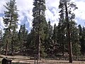
community of Forest Falls in San Bernardino National Forest, including the San Gorgonio Wilderness in California, United States. The fire was reported on July...
7 KB (666 words) - 14:35, 28 March 2024
states Mont de Gébroulaz 3,511 11,519 Vanoise massif, France Mount San Gorgonio 3,505 11,499 California, US Mount Kitchener 3,505 11,499 Canadian Rockies...
139 KB (176 words) - 08:35, 3 October 2024

Scouting in California (redirect from Girl Scouts of San Gorgonio Council)
San Diego. Retrieved January 11, 2015. "Camp WiWoCa". Girl Scouts of San Gorgonio. Retrieved January 11, 2015. "About our Council | Sierra Nevada". Girl...
54 KB (4,748 words) - 19:15, 22 September 2024

Gorgonio in 1824. The ranch was to be one of the Mission's principal rancherias, and the most distant, and it occupied most of today's San Gorgonio Pass...
138 KB (5,880 words) - 06:58, 19 October 2024
499 feet (600 to 3505 m). The forest includes seven wilderness areas: San Gorgonio, Cucamonga, San Jacinto, South Fork, Santa Rosa, Cahuilla Mountain and...
10 KB (958 words) - 00:57, 8 October 2024

Fork begins in the subalpine zone at about 10,000 ft (3,000 m) on San Gorgonio Mountain and descends steeply southeast to the Middle Fork, which flows...
11 KB (785 words) - 20:51, 30 September 2023
Anderson Peak is a mountain on the Mount San Gorgonio crestline in Southern California's San Gorgonio Wilderness, which is part of the San Bernardino National...
2 KB (123 words) - 17:13, 19 July 2024

San Andreas Fault (category San Gorgonio Pass)
The San Andreas Fault is a continental right-lateral strike-slip transform fault that extends roughly 1,200 kilometers (750 mi) through the U.S. state...
37 KB (3,735 words) - 17:48, 20 October 2024