
Greater Sudbury Municipal Road 55 is a municipal road in the city of Greater Sudbury, Ontario, Canada. Extending from Whitefish to Coniston under a variety...
12 KB (728 words) - 15:39, 1 August 2024

article lists all of the numbered municipal roads in Greater Sudbury, Ontario. Municipal roads in Greater Sudbury are generally numbered with odd numbers...
17 KB (226 words) - 01:04, 12 July 2024

Greater Sudbury Municipal Road 35 is a municipal road in the city of Greater Sudbury, Ontario, Canada. Extending from Chelmsford to Downtown Sudbury, most...
8 KB (574 words) - 16:30, 20 June 2024
Southwest and Southeast Bypasses (redirect from Southeast Bypass (Sudbury))
Southeast Bypass are two separately-constructed contiguous roads in the city of Greater Sudbury, in the Canadian province of Ontario, which form a bypass...
19 KB (1,775 words) - 04:56, 24 August 2024
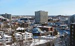
Sudbury, officially the City of Greater Sudbury, is the largest city in Northern Ontario by population, with a population of 166,004 at the 2021 Canadian...
130 KB (10,024 words) - 01:19, 10 September 2024
urban core of Greater Sudbury, Ontario. This list includes only those neighbourhoods that fall within the pre-2001 city limits of Sudbury — for communities...
33 KB (3,857 words) - 14:25, 23 September 2024
Ontario Highway 144 (redirect from Northwest Bypass (Sudbury))
bypass realignment. The City of Greater Sudbury had widened Municipal Road 35 between the eastern intersection of Municipal Road 21 (Notre Dame Street) in Azilda...
15 KB (1,240 words) - 14:52, 22 August 2024
The 2010 Greater Sudbury municipal election was held on October 25, 2010 to elect a mayor and 12 city councillors in Greater Sudbury, Ontario. In addition...
26 KB (1,418 words) - 04:28, 8 September 2023

Walden, Ontario (redirect from Creighton, Greater Sudbury, Ontario)
Regional Municipality of Sudbury when regional government was introduced, the town was dissolved when the city of Greater Sudbury was incorporated on January...
36 KB (4,160 words) - 22:10, 22 September 2024
Onaping Falls (category Neighbourhoods in Greater Sudbury)
report called the Constellation City listed many improvements to Greater Sudbury's municipal governance The committee visited and spoke to citizens in several...
11 KB (819 words) - 12:41, 3 August 2024

Big Nickel (category Culture of Greater Sudbury)
nickel, located at the grounds of the Dynamic Earth science museum in Greater Sudbury, Ontario, Canada, and is the world's largest depiction of a coin. The...
14 KB (2,034 words) - 18:57, 12 December 2022


Ontario Highway 549 (category Roads in Greater Sudbury)
Municipality of Sudbury. Today it is known as Greater Sudbury Road 10. Highway 549 followed what is now Sudbury Municipal Road 10 (Panache Lake Road). It travelled...
5 KB (489 words) - 16:12, 25 July 2024

Ontario Highway 545 (category Roads in Greater Sudbury)
Sudbury Municipal Road 85, along the former Highway 69 concurrency as Sudbury Municipal Road 84, and north of Capreol as Sellwood Avenue, Milnet Road...
7 KB (714 words) - 16:12, 25 July 2024

Ontario Highway 541 (category Roads in Greater Sudbury)
today known as Sudbury Municipal Road 55, but the route of Highway 17 through Sudbury in 1973. It progressed northeast through Sudbury, leaving the urban...
9 KB (796 words) - 16:12, 25 July 2024
Ontario Highway 69 (category Roads in Greater Sudbury)
In conjunction with Highway 400, it links Toronto with the city of Greater Sudbury at Highway 17, via Parry Sound. It is part of the Trans-Canada Highway...
59 KB (4,499 words) - 19:29, 19 August 2024
Gibson Lake is a lake in geographic Hutton Township in Greater Sudbury in Northeastern Ontario, Canada. It is in the Great Lakes Basin and is on the Vermilion...
3 KB (176 words) - 07:24, 3 June 2024

Ontario Highway 536 (category Roads in Greater Sudbury)
Mine. Highway 536 followed most of what is now Municipal Road 24, north from Greater Sudbury Road 55 (Old Highway 17). The route existed from 1956 until...
6 KB (492 words) - 20:22, 29 August 2024

Ontario Highway 537 (redirect from Greater Sudbury Road 537)
2 mi) that continues as Municipal Road 537. The route begins at Estaire Road (unsigned Highway 7279) within Greater Sudbury near an interchange with...
14 KB (1,261 words) - 17:51, 25 July 2024
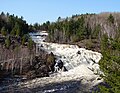
Onaping River (category Rivers of Greater Sudbury)
The Onaping River is a river in Greater Sudbury and Sudbury District in Northeastern Ontario, Canada. It is in the Great Lakes Basin and is a right tributary...
7 KB (479 words) - 22:33, 10 May 2023
List of former Ontario provincial highways (category Lists of roads in Ontario)
Municipality of Sudbury as Long Lake Road, part of Regional Road 80. Now designated Greater Sudbury Municipal Road 80. Highway 544 – Downtown Sudbury to Cartier...
34 KB (3,672 words) - 01:00, 10 August 2024
Ontario Highway 17 (category Roads in Greater Sudbury)
first phase of this route, extending the existing freeway from Municipal Road 55 in Sudbury for six kilometres farther west through the Den-Lou neighbourhood...
88 KB (6,787 words) - 23:30, 1 September 2024

Harrow, London (redirect from Harrow, Greater London)
village and the adjoining hamlets of Greenhill, Roxeth, and Sudbury. By 1865, a series of roads had been built in Greenhill, including College, Roxborough...
63 KB (6,238 words) - 00:45, 27 August 2024
Frederick Frederick Municipal Airport, Frederick Frostburg State University, Frostburg Pilot Travel Center at 3000 Chestnut Ridge Road, Grantsville 7-Eleven...
16 KB (1,404 words) - 21:30, 1 September 2024

Nairn and Hyman (redirect from Prospect Hill, Sudbury District, Ontario)
into municipal roads and runs directly through the town. Upon crossing the municipal boundary into Greater Sudbury, it becomes Municipal Road 55. The...
32 KB (3,557 words) - 13:56, 15 March 2024

Ontario Highway 400 (category Infobox road instances in Ontario)
to the Canadian West, via a connection with the mainline of the TCH in Sudbury. The highway also serves as the primary route from Toronto to southern...
82 KB (6,153 words) - 02:02, 1 October 2024

GTA, in Greater Sudbury. In addition to publicly funded colleges, there are also many private career colleges spread throughout the Greater Toronto Area...
113 KB (9,888 words) - 00:50, 28 September 2024
basin in Sudbury District and Greater Sudbury in Northeastern Ontario, Canada. The river begins at an unnamed lake in Unorganized Sudbury, Sudbury District...
20 KB (1,691 words) - 22:34, 10 May 2023
List of controlled-access highways in Ontario (category Lists of roads in Ontario)
2012. "Construction Set to Begin on the Maley Drive Extension Project in Sudbury". news.ontario.ca. October 12, 2016. Retrieved 2024-07-29. Filey, Mike...
14 KB (610 words) - 02:24, 1 September 2024