Guam Highway 4 (GH-4) is one of the primary automobile highways in the United States territory of Guam. GH-4 is the major highway along the southeastern...
3 KB (215 words) - 09:07, 26 August 2024
living north of Guam Highway 4 are zoned to Andersen Elementary and Andersen Middle School, while people living south of Guam Highway 4 are zoned to McCool...
22 KB (1,705 words) - 10:06, 6 August 2024

Guam Highway 1 (GH-1), also known as Marine Corps Drive, is one of the primary automobile routes in the United States territory of Guam. It runs in a...
11 KB (943 words) - 04:21, 10 June 2022
Guam Highway 17 (GH-17) (named Cross Island Road) is one of the primary automobile highways in the United States territory of Guam. GH-17 provides a more...
2 KB (103 words) - 09:09, 26 August 2024

living north of Guam Highway 4 are zoned to Andersen Elementary and Andersen Middle School, while people living south of Guam Highway 4 are zoned to McCool...
8 KB (743 words) - 05:58, 11 January 2024
Guam Highway 7 (GH-7) is one of the primary automobile highways in the United States territory of Guam. The route provides access to two primary locations:...
2 KB (177 words) - 09:11, 26 August 2024
Guam Highway 2 is one of the primary automobile routes in the United States territory of Guam. The route runs in a south to north direction, from the...
2 KB (112 words) - 09:07, 26 August 2024

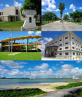
Guam (/ˈɡwɑːm/ GWAHM; Chamorro: Guåhan [ˈɡʷɑhɑn]) is an organized, unincorporated territory of the United States in the Micronesia subregion of the western...
107 KB (9,922 words) - 06:43, 17 August 2024

living north of Guam Highway 4 are zoned to Andersen Elementary and Andersen Middle School, while people living south of Guam Highway 4 are zoned to McCool...
8 KB (609 words) - 03:10, 16 May 2024

general public. This busy, but yet unnumbered highway offers a shortcut from Barrigada to Tamuning and Tumon, Guam's economic center. The U.S. Census Bureau...
16 KB (1,262 words) - 14:25, 22 August 2024
Highways in Guam are maintained by the Department of Public Works in the United States territory of Guam. U.S. Roads portal Staff. "Part 2a: History"....
14 KB (115 words) - 21:26, 3 March 2024
Guam Highway 18 (GH-18) is one of the primary automobile highways in the United States territory of Guam. In spite of its main highway designation, GH-18...
2 KB (173 words) - 09:12, 26 August 2024
Route 4 Washington State Route 4 Primary State Highway 4 (Washington) (former) West Virginia Route 4 Territories Guam Highway 4 Puerto Rico Highway 4 (former)...
14 KB (990 words) - 02:13, 5 August 2024
Guam Highway 5 (GH-5) is one of the primary automobile highways in the United States territory of Guam. The western end of GH-5 is in Santa Rita at a junction...
2 KB (114 words) - 09:10, 26 August 2024
Guam Highway 10 (GH-10) is one of the primary automobile highways in the United States territory of Guam. GH-10 begins at a junction off GH-4 near Pago...
2 KB (152 words) - 09:07, 26 August 2024
Guam Highway 15 (GH-15) is one of the primary automobile highways in the United States territory of Guam. GH-15's route covers mainly the northeast coast...
3 KB (176 words) - 09:09, 26 August 2024

Naval Base Guam is a strategic U.S. naval base located on Apra Harbor and occupying the Orote Peninsula. In 2009, it was combined with Andersen Air Force...
8 KB (780 words) - 09:24, 18 April 2024
Guam Highway 3 (GH-3) is one of the primary automobile highways in the United States territory of Guam. It runs in a south to north direction, from a junction...
2 KB (149 words) - 09:07, 26 August 2024
Register of Historic Places in Guam. There are currently 134 listed sites spread across 17 of the 19 villages of Guam. The villages of Agana Heights and...
45 KB (452 words) - 00:49, 25 August 2024

Andersen Air Force Base (redirect from North Field, Guam)
located primarily within the village of Yigo in the United States territory of Guam. The host unit at Andersen AFB is the 36th Wing (36 WG), assigned to the...
45 KB (4,534 words) - 13:20, 11 February 2024
village located on the southeastern coast of the United States territory of Guam. The village's original Chamoru name, Inalåhan, was altered when transliterated...
9 KB (661 words) - 05:19, 16 May 2024

Merizo Bell Tower (category Buildings and structures on the National Register of Historic Places in Guam)
The Merizo Bell Tower, on Guam Highway 4 in Merizo, Guam, is a bell tower that was built in 1914 or 1919. It was listed on the U.S. National Register of...
2 KB (202 words) - 05:17, 19 December 2022

1 (2007 est.) Airports - with unpaved runways: total: 1 under 914 m: 1 (2007 est.) Guam List of highways in Guam "About PAG". Port Authority of Guam....
2 KB (208 words) - 01:42, 16 July 2024

Umatac Outdoor Library (category Buildings and structures on the National Register of Historic Places in Guam)
The Umatac Outdoor Library, located on Guam Highway 4 in Umatac, Guam, was built in 1933 by Francisco Quinata Sanchez and Umatac villagers. It was listed...
2 KB (84 words) - 18:55, 19 February 2024

Malesso Japanese Rice Mill (category Buildings and structures on the National Register of Historic Places in Guam)
Merizo, Guam. It is a single-story concrete structure with two rooms, located on a small parcel in a residential area south of Guam Highway 4 off Barcinas...
2 KB (209 words) - 10:36, 19 May 2023

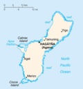
Guam is an island territory of the United States, located in the Northwest Pacific Ocean, and is part of the Mariana Islands. Guam lies in the path of...
89 KB (8,843 words) - 11:36, 22 August 2024
San Vitores Martyrdom Site (category National Register of Historic Places in Guam)
Martyrdom Site, located 0.7 miles south of Bijia Point off Guam Highway 4 in Tamuning, Guam, has significance from 1672. It was listed on the National...
2 KB (136 words) - 21:21, 11 September 2022
Highways are split into at least four different types of systems in the United States: Interstate Highways, U.S. Highways, state highways, and county...
23 KB (1,040 words) - 01:19, 5 August 2024

Pago Bay (redirect from Pago, Guam)
towers would block the iconic views along the Pago River Bridge and Guam Highway 4, with one Chamoru man bringing up the ancient legend: "It's a 21st century...
14 KB (1,427 words) - 03:07, 16 May 2024

The Guam Institute, located off in Guam Highway 1 in Hagåtña (formerly Agana or Agaña), Guam, was listed on the U.S. National Register of Historic Places...
3 KB (304 words) - 11:24, 3 June 2024