
Hartsop is a small village in the English Lake District. It lies in the Patterdale valley, near Brothers Water, Hayeswater and Kirkstone Pass. It consists...
4 KB (293 words) - 12:16, 29 April 2024

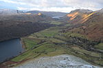
Brothers Water is a small lake in the Hartsop valley, in the eastern region of the Lake District in England. Once called Broad Water, it lies at the northern...
4 KB (379 words) - 22:41, 5 September 2022
Harter Fell, Mardale Hartsop above How Hartsop Dodd Haycock Haystacks Helm Crag Helvellyn Hen Comb Heron Pike High Crag High Hartsop Dodd High Pike (Scandale)...
23 KB (2,842 words) - 18:49, 25 May 2024

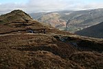
Hartsop Dodd is a fell in the English Lake District, standing to the south east of Brothers Water. It is a subsidiary top on the north ridge of Caudale...
3 KB (358 words) - 19:18, 25 December 2023

041 ft) Heron Pike, 612 m (2,008 ft) Hartsop above How, 570 m (1,870 ft) Great Mell Fell, 537 m (1,762 ft) High Hartsop Dodd, 519 m (1,703 ft) Low Pike, 508 m...
66 KB (2,878 words) - 15:00, 12 April 2024
Hartsop above How is a fell in the English Lake District, an outlier of the Helvellyn range in the Eastern Fells. It stands above Brothers Water and the...
4 KB (447 words) - 23:13, 27 March 2024

High Hartsop Dodd is a fell in the English Lake District, an outlier of the Fairfield group in the Eastern Fells. It stands above Kirkstone Pass on the...
4 KB (543 words) - 19:49, 11 April 2022
civil parish of Patterdale also includes the villages of Glenridding and Hartsop. As well as the southern end of Ullswater, it also includes the smaller...
6 KB (587 words) - 12:10, 29 April 2024
England, within the Lake District National Park, about a mile north-east of Hartsop. Located at an altitude of 479 m (1,572 ft), the lake has an area of 5...
3 KB (273 words) - 10:56, 20 April 2023
Green Slate Company is just to the Ambleside side of the summit. Nearby is Hartsop Hall lead mine. Caudale slate mine is a few miles further down, on the...
5 KB (488 words) - 21:50, 24 October 2022
open space acquired by the Trust under the Land scheme was farmland at Hartsop in the Lake District; the first country house was Cotehele in Cornwall...
44 KB (4,946 words) - 22:25, 7 July 2024

The best starting point for this uncontroversial ascent of The Nab is Hartsop village in Patterdale, just off the A592 main road, where there is a large...
5 KB (574 words) - 23:53, 10 November 2023

Haresceugh Harker, Harker Marsh, Harraby Harrington, Harriston, Hartley, Hartsop, Hassness Haverigg, Haverthwaite, Hawcoat, Hawksdale Hawkshead, Hawkshead...
21 KB (1,274 words) - 09:30, 14 March 2024

the central of the three dodds as seen from Hartsop Hall: (Low) Hartsop Dodd, Middle Dodd and High Hartsop Dodd. These names have nothing to do with relative...
16 KB (2,085 words) - 23:17, 5 February 2024

point where a long subsidiary spur sweeps off to the north east. This is Hartsop above How and, although in reality part of Hart Crag, was treated as a...
5 KB (623 words) - 02:40, 21 August 2023

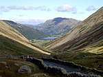
Longsleddale. Gray Crag is almost invariably ascended from the hamlet of Hartsop where there is a car park, Hayeswater Gill is followed for 1.5 kilometres...
3 KB (346 words) - 12:16, 22 October 2023

here the walker can either circuit Deepdale via Fairfield, Hart Crag and Hartsop above How or swing north around Grisedale, taking in Dollywaggon Pike,...
5 KB (640 words) - 08:36, 17 May 2023

Patterdale starts from the car park at Brothers Water and takes the path to Hartsop Hall. Here the rising path up Dovedale is taken. As the crags are approached...
6 KB (750 words) - 17:51, 14 February 2024

11-kilometre (7-mile) walk over the neighbouring fells of Hartsop above How, Hart Crag, Dove Crag and High Hartsop Dodd, starting and finishing at Brothers Water...
4 KB (431 words) - 21:53, 6 November 2023
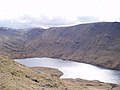
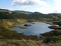
England. The lake is situated about a mile (1.6 km) SE of the hamlet of Hartsop in the Patterdale Valley. It nestles between The Knott to its east and...
3 KB (188 words) - 05:00, 19 July 2022

2/06/magenta Boredale Hause (bridleway) 399 m (1,309 ft)/ NY408157 Patterdale/ Hartsop/ NY405132 Boredale/ Boredale Head/ NY418169 Or Boardale Hause 2/07/blue...
46 KB (2,578 words) - 13:59, 8 January 2024
old maps and much more. Cumbria County History Trust: Patterdale with Hartsop Archived 7 March 2022 at the Wayback Machine (nb: provisional research...
9 KB (715 words) - 11:43, 7 June 2024

Scottish Borders 619 113 2,031 371 80 NT855152 Hu,Sim,Hew,N,D 240 197 Hartsop Dodd Stony Cove Pike 34C Lake District - Far Eastern Fells Cumbria 618...
93 KB (1,909 words) - 17:36, 25 April 2024
Derbyshire 52°47′N 1°31′W / 52.78°N 01.52°W / 52.78; -01.52 SK3221 Hartsop Cumbria 54°30′N 2°55′W / 54.50°N 02.92°W / 54.50; -02.92 NY4013 Hart...
76 KB (26 words) - 20:44, 9 April 2022

Brock Crags is a fell in the English Lake District, standing above Hartsop in the Far Eastern Fells. It forms part of the perimeter of Martindale, lying...
4 KB (435 words) - 05:02, 24 November 2023
first hound to win a hundred prizes but was poisoned by a competitor and Hartsop Magic who won thirty two prizes in 1985, twenty six in 1986 and thirty...
9 KB (1,130 words) - 18:56, 22 May 2024

by moving a little to the south west. The usual route of ascent is from Hartsop via Hayeswater. An old zig-zag climbs from just below the tarn although...
3 KB (307 words) - 08:59, 5 May 2023

crossroads lead to Patterdale, Boredale, Bannerdale via Beda Fell, and Hartsop, in addition to the route up Steel Edge to the summit of Place Fell. The...
5 KB (685 words) - 07:52, 19 June 2024

Patterdale throughout the 18th century. A lease for the mining rights at Hartsop Hall Mine is dated 1696; the parish registers recorded the burials of "a...
103 KB (16,039 words) - 16:29, 28 June 2024

the walkers’ crossroads of Boredale Hause. From here paths run down to Hartsop, Patterdale and Boredale, while a further bridleway cuts across Beda Fell...
4 KB (525 words) - 08:17, 17 May 2023