Peru Highway 2 is a transversal highway in Peru that connects the cities of Piura and Paita. It is part of the "North Interoceanic Highway". The road is...
966 bytes (53 words) - 09:56, 8 August 2024
primary highways of Peru are assigned using a numeric designation and sometimes a name. Spur and loop routes are designated with the parent highway's number...
3 KB (286 words) - 06:17, 9 March 2023

Peru, officially the Republic of Peru, is a country in western South America. It is bordered in the north by Ecuador and Colombia, in the east by Brazil...
218 KB (22,294 words) - 22:39, 4 October 2024

Honduras, Mexico, Nicaragua, Panama, Peru, Canada, and the United States signed the Convention on the Pan-American Highway, whereby they agreed to achieve...
71 KB (8,734 words) - 10:49, 26 September 2024

The Interoceanic Highway or Trans-oceanic highway is an international, transcontinental highway in Peru and Brazil that connects the two countries. It...
12 KB (1,146 words) - 13:50, 15 August 2024

The Carretera Central of Peru or National Route 22 is a two-lane highway that crosses through Central Peru. It begins in the city of Lima, and connects...
7 KB (656 words) - 23:34, 17 November 2023

south of Lima, along the desert coast of southern Peru. Further south along the Pan-American Highway lies the city of Nazca. Ica lies on the border of...
12 KB (844 words) - 01:14, 13 August 2024
crashes on a highway in the Ayacucho region in the Andes mountains. 7 August – Stefano Peschiera wins a bronze medal representing Peru at the 2024 Summer...
14 KB (1,229 words) - 00:25, 25 September 2024

Lima (redirect from Lima, Peru)
northern Peruvian coast. The Central Highway (Spanish: Carretera Central) connects the eastern districts with cities in central Peru. The highway extends...
153 KB (16,098 words) - 03:31, 25 September 2024

bypass 1.5 miles (2.4 km) north of downtown, while current U.S. 31 is a four-lane highway 3 miles (5 km) west of downtown. The Peru city limits extend...
23 KB (2,422 words) - 02:05, 12 September 2024

The economy of Peru is an emerging, mixed economy characterized by a high level of foreign trade and an upper middle income economy as classified by the...
109 KB (10,341 words) - 08:50, 26 June 2024

first of three military conflicts between Ecuador and Peru during the 20th century. During the war, Peru occupied the western Ecuadorian province of El Oro...
48 KB (5,568 words) - 22:40, 23 July 2024

Peruvian Amazonia (Spanish: Amazonía del Perú), informally known locally as the Peruvian jungle (Spanish: selva peruana) or just the jungle (Spanish: la...
23 KB (2,930 words) - 03:40, 23 September 2024

[tɾuˈxiʝo]; Quechua: Truhillu; Mochica: Cɥimor) is a city in coastal northwestern Peru and the capital of the Department of La Libertad. It is the third most populous...
135 KB (13,175 words) - 14:13, 25 September 2024
List of earthquakes in 2024 (redirect from 2024 southern Peru earthquake)
National Earthquake Information Center (15 February 2024). "M 5.2 - 13 km NNW of Chancay, Peru". United States Geological Survey. Retrieved 18 February 2024...
127 KB (7,292 words) - 22:14, 3 October 2024

Jorge Chávez International Airport (redirect from Aeropuerto Internacional Jorge Chávez - Lima/Callao Perú)
SPJC, SPIM) is the main international airport serving Lima, the capital of Peru. It is located in Callao, 11 kilometers (6.8 mi) northwest of Lima Center...
44 KB (3,046 words) - 23:33, 21 September 2024

Located on the Illinois River, Peru lies 3 miles (4.8 km) west of the intersection of two major interstate highways: Interstate 39 and Interstate 80...
21 KB (1,677 words) - 16:38, 8 August 2024
King's Highway 401, commonly referred to as Highway 401 and also known by its official name as the Macdonald–Cartier Freeway or colloquially referred to...
232 KB (16,261 words) - 06:13, 3 September 2024
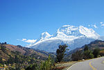
Department of Ancash (redirect from Ancash (Department of Peru))
cycles of these two sea currents that affect Peru are hard to predict. Further north along the Pan-American highway, numerous islands and islets dot the sea...
40 KB (3,840 words) - 23:56, 12 August 2024

Pucallpa (redirect from Pucallpa, Peru)
east of Peru and which contains the second most important river port in the Peruvian Amazon (behind Iquitos). The Federico Basadrees highway is the main...
39 KB (4,209 words) - 23:19, 25 September 2024
Arequipa a branch goes to Puno and then to Bolivia. Other important highways in Peru are the Longitudinal de la Sierra, that goes from north to south in...
11 KB (1,071 words) - 11:55, 2 June 2024

Windsor began replacing its Helvetica signs with Highway Gothic in 2018. Use of the font is seen in Peru (under different series labels), New Zealand, Indonesia...
17 KB (1,957 words) - 02:35, 5 September 2024

and New York State Route 442 (an east–west highway), also known as the Bear Swamp Road, intersect at Peru village. As of the census of 2000, there were...
12 KB (1,080 words) - 17:16, 5 May 2024
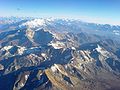
Andes (redirect from Andes of Peru)
connects Chile with Peru via the Andes, and there are others that make the same connection via southern Bolivia. There are multiple highways in Bolivia that...
60 KB (6,962 words) - 12:21, 23 September 2024

airlines offering service between many of Peru's cities. Peru has land borders with five countries and has highway connections with all but Colombia. International...
31 KB (3,343 words) - 00:09, 20 July 2024
the Rambler: What Is The Longest Road in the United States?". Federal Highway Administration. Retrieved December 4, 2014. "G7京新高速公路全线贯通-图片报道-中华人民共和国交通运输部"...
12 KB (227 words) - 12:12, 23 August 2024

wave came ashore. A tsunami did occur on the Peruvian coast. It flooded part of Lima's Costa Verde highway, and much of Pisco's shore. It has been reported...
16 KB (1,560 words) - 21:47, 27 September 2024

Highway where it serves as the main street in Máncora, Peru A typical expressway in China An expressway exit in Guizhou, China North Lantau Highway in...
49 KB (4,930 words) - 10:58, 20 September 2024

(Spanish pronunciation: [amaˈsonas]) is a department and region in northern Peru bordered by Ecuador on the north and west, Cajamarca on the west, La Libertad...
43 KB (4,546 words) - 01:04, 13 August 2024

Department of San Martín (redirect from San Martín (Department of Peru))
August 19, 1821, Moyobamba was the first Peruvian city in declaring its independence. The construction of a highway in recent years has increased the exchange...
8 KB (516 words) - 01:06, 13 August 2024