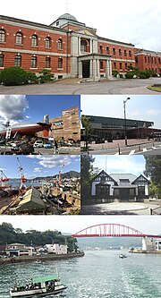
Kure (呉市, Kure-shi) is a city in Hiroshima Prefecture, Japan. As of 30 April 2023[update], the city had an estimated population of 208,024 in 106,616 households...
20 KB (1,377 words) - 22:15, 21 July 2024

Hiroshima-Kure Road (広島呉道路, Hiroshima-Kure Dōro) is a toll road in Hiroshima Prefecture. It is owned and operated by the West Nippon Expressway Company...
4 KB (88 words) - 15:26, 15 July 2024
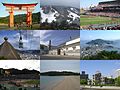
Castle Kure Portopia Park Itsukushima Shrine and Torii Gate (Hatsukaichi) Hiroshima Peace Memorial (Hiroshima City) Taishaku Valley (Shobara) Road of longing...
21 KB (1,098 words) - 02:19, 7 August 2024

of pregnancies occurring in Hiroshima and Nagasaki, and in a control city, Kure, located 29 km (18 mi) south of Hiroshima, to discern the conditions and...
220 KB (25,255 words) - 04:42, 8 August 2024

forests cover over 50% of the town area. Hiroshima Prefecture Aki-ku, Hiroshima Minami-ku, Hiroshima Kure Kaita Saka has a humid subtropical climate...
6 KB (401 words) - 17:43, 15 December 2023
code Damansara–Shah Alam Elevated Expressway, route E31 in Malaysia Hiroshima-Kure Road, route E31 in Japan Long Win Bus Route E31 in Hong Kong This disambiguation...
479 bytes (107 words) - 01:45, 20 October 2021

levels. Hiroshima Prefecture Kure Higashihiroshima Akitakata Hatsukaichi Akiota Kitahiroshima Fuchū Saka Kumano Kaita The region where Hiroshima stands...
63 KB (5,204 words) - 16:22, 6 August 2024

Shiraichi Station, Fukuyama Station, Kure Station and Mihara Station. Unusually among major Japanese airports, Hiroshima Airport has no railway station. The...
12 KB (811 words) - 09:54, 20 June 2024
Higashihiroshima (redirect from Higashi-Hiroshima, Hiroshima)
temperature range (summer and winter) are large. Hiroshima Prefecture Hiroshima Takehara Akitakata Miyoshi Kure Mihara Kumano Sera Ōsakikamijima Higashihiroshima...
16 KB (1,006 words) - 00:05, 5 May 2024

Akinada Bridge (安芸灘大橋, Akinada Ō-hashi) is a suspension bridge in Kure, Hiroshima, Japan that crosses the Seto Inland Sea. Completed in 1999, it has...
3 KB (219 words) - 10:30, 23 June 2024

Ondō Bridge (category Transport in Hiroshima Prefecture)
known as Ondoo Bridge and Ondo Bridge is a red road bridge that connects the mainland of Kure City, Hiroshima, with Kurahashi Island (formerly Ondo Town,...
7 KB (765 words) - 18:13, 29 May 2024

Higashihiroshima-Kure Expressway (東広島呉自動車道, Higashihiroshima-Kure Jidōsha-dō) is an national expressway in the southern part of Hiroshima Prefecture. The...
4 KB (208 words) - 10:50, 27 April 2024

Akinada Tobishima Kaido (category Roads in Hiroshima Prefecture)
Link Bridges (安芸灘諸島連絡架橋, Akinada-shotō-renraku-kakyō), is a road connecting Kure, Hiroshima to seven of the Geiyo Islands in the Seto Inland Sea, Japan...
8 KB (512 words) - 20:50, 7 July 2024
In This Corner of the World (film) (category Films about the atomic bombings of Hiroshima and Nagasaki)
is set in the 1930s–1940s in Hiroshima and Kure in Japan, roughly 10 years before and after the atomic bombing of Hiroshima, but mainly in 1944–45. In the...
76 KB (4,903 words) - 07:59, 26 June 2024

I-400-class submarine (redirect from Operation Road's End)
January 1943 at the Kure, Hiroshima arsenal. Within a year the plan was scaled back to five, of which only three (I-400 at Kure, and I-401 and I-402...
39 KB (4,665 words) - 20:04, 26 June 2024
Japan National Route 31 (category Roads in Hiroshima Prefecture)
connecting Kaita, Hiroshima and Kure in Japan. Length: 20.1 km (12.5 mi) Origin: Kaita, Hiroshima (originates at junction with Route 2) Terminus: Kure (ends at...
2 KB (143 words) - 04:17, 18 March 2024
Big Joys, Small Sorrows (category Films shot in Kure)
Hokkaido Hiroshima Peace Memorial, Hiroshima Kure Maritime Safety University, Kure, Hiroshima Prefecture Itsukushima Shinto Shrine, Miyajima, Hiroshima Prefecture...
14 KB (1,021 words) - 04:06, 5 October 2023
Barefoot Gen (redirect from Gen of Hiroshima)
Nakazawa's experiences as a survivor of the Hiroshima atomic bombing. The series begins in 1945 in and around Hiroshima, Japan, where six-year-old Gen Nakaoka...
44 KB (5,358 words) - 16:45, 5 August 2024

Ōsakishimojima (category Islands of Hiroshima Prefecture)
via a series of bridges to the mainland of Honshu near the city of Kure, Hiroshima, as well as eastwards to Okamura Island, the current terminus of the...
8 KB (611 words) - 11:53, 11 June 2024

On 18 August I-58, arrived back at Kure. On 2 September Japan surrendered. On 1 April 1946 in "Operation Road's End" I-58, stripped of all usable equipment...
15 KB (1,670 words) - 03:36, 10 May 2024
List of highways numbered 31 (redirect from State Road 31)
31 (Iceland) NH 31 Road 31 N31 road (Ireland) Highway 31 (Israel) Autostrada A31 (Italy) Japan National Route 31 Hiroshima-Kure Road National Route 31...
8 KB (542 words) - 23:22, 4 April 2024

Ōmishima Island, Ehime. It can also be accessed by road from the city of Kure, Hiroshima Prefecture through the Akinada Islands Connecting Bridges. The last...
4 KB (190 words) - 07:21, 21 May 2024

Seto Inland Sea (category Landforms of Hiroshima Prefecture)
Inland Sea include Osaka, Kobe, and Hiroshima. Smaller scale manufacturing and industry can also be found in Kurashiki, Kure, Fukuyama, and Ube in Honshū, and...
22 KB (2,794 words) - 05:59, 21 May 2024

RCC Broadcasting (category Mass media in Hiroshima)
Higashihiroshima-Kurose 60CH Digital (Button 3) Hiroshima JOER-DTV 18CH Kure 18CH Fukuyama 16CH Stereo Hiroshima JOER 1350 kHz 50 kW Monaural Fukuyama JOEO...
8 KB (654 words) - 16:20, 6 August 2024
Japan National Route 185 (category Roads in Hiroshima Prefecture)
Japan connecting Kure, Hiroshima and Mihara, Hiroshima in Japan, with a total length of 68.4 km (42.5 mi). "一般国道の路線別、都道府県別道路現況" [Road statistics by General...
1 KB (72 words) - 17:34, 19 March 2024
operated by the Japan Maritime Self-Defense Force (JMSDF) and the US Navy Kure Naval Base - now a Japan Self-Defense Forces facility and museum Maizuru...
4 KB (496 words) - 18:31, 19 February 2024

Line) Hiroshima Akinagahama, 1994 (Kure Line) Jike, 2017 (San'yo Main Line) Karugahama, 1999 (Kure Line) Kōdo-Homachigawa, 2017 (San'yō Main Line) Kure-Portopia...
27 KB (2,259 words) - 15:12, 7 August 2024

San'yō Expressway (redirect from Hiroshima-Iwakuni Road)
Highway Network AH1) is an expressway in Japan, running from Kobe through Hiroshima along the Inland Sea and terminating in Yamaguchi Prefecture. The entire...
24 KB (88 words) - 08:04, 7 August 2023

Hotel Koyagi Shima (Fukuoka #2) Kumamoto (First location of Fukuoka #1) Kure Kurume Kyota - branches at Hakata Maibara Maisure Minato-ku Mito Mitsu Branch...
19 KB (1,533 words) - 03:26, 8 May 2024

Japan National Route 375 (category Roads in Hiroshima Prefecture)
Japan connecting Kure, Hiroshima and Ōda, Shimane in Japan, with a total length of 163.4 km (101.53 mi). "一般国道の路線別、都道府県別道路現況" [Road statistics by General...
1 KB (72 words) - 21:31, 20 March 2024