
The Kaouar (or Kawar) is a series of ten oases in the southern Sahara in northeast Niger, covering about 75 km (50 mi) from north to south, and 1–5 km...
3 KB (415 words) - 17:51, 6 May 2024
lies protected from the desert dunes under the Kaouar Cliffs and is the largest town along the Kaouar escarpment. It is known for its gardens, for salt...
11 KB (626 words) - 19:49, 24 August 2024

Further east of the Fezzan with its trade route through the valley of Kaouar to Lake Chad, Libya was impassable due to its lack of oases and fierce sandstorms...
32 KB (3,835 words) - 05:45, 8 September 2024

region to the natron salt pans along the string of oases formed by the Kaouar cliffs in north east Niger. Food and supplies were carried from Agadez each...
6 KB (691 words) - 13:27, 2 July 2024

trade routes; most of eastern and south-eastern Niger, including Bilma and Kaouar, was under Kanem's control in this period. Islam had been introduced to...
145 KB (14,127 words) - 19:22, 25 September 2024
Aïr Mountains rise up. To the southeast, the Ténéré is bordered by the Kaouar cliffs running 100 km north to south. At the base, lies a string of oases...
13 KB (1,382 words) - 12:10, 15 August 2024
season, some of these ponds almost dry up completely. From the cliffs, the Kaouar valley can be reached. There is a desert made of pebbles to the west. Beyond...
11 KB (1,101 words) - 12:07, 24 June 2024

ranged along the long southern border with Nigeria; the Lake Chad basin and Kaouar in the far east, populated by Kanuri farmers and Toubou pastoralists who...
7 KB (777 words) - 13:29, 18 May 2024
the oasis of Bilma, southernmost of a north–south string of oases of the Kaouar rise. The Erg covers an area of approximately 455,000 square kilometres...
6 KB (305 words) - 13:55, 17 February 2021

the same time. The Mada, however, have since largely emigrated to Borkou, Kaouar and Kanem. The early 17th century also saw the arrival of three clans from...
122 KB (13,689 words) - 15:14, 15 September 2024

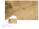
of 2,215 people (2012). It is also a stopping point of the Agadez to the Kaouar caravans of the Azalay. Fachi is 160 kilometres (100 miles) west of Bilma...
6 KB (240 words) - 16:39, 6 September 2024
The abandoned Djado fort in Bilma, located on the Bornu-Kaouar-Fezzan-Tripoli trade route. The fort was under Kanem-Bornu during the reign of Mai Idris...
33 KB (3,881 words) - 19:52, 21 August 2024
Bunce company employee residing in Jade City (season 2–3; season 5). Karim Kaouar Professional pastry chef, Two Mile mine camp cook (season 5–6). Peter Niu...
15 KB (1,051 words) - 17:55, 29 April 2024
with settlements and trade routes clinging to the Air in the north, the Kaouar and shore of Lake Chad in the west, and (apart for a scattering of oases)...
37 KB (4,732 words) - 18:21, 23 June 2024

Trans-Saharan trade routes, the oasis towns of the Aïr and the eastern Kaouar Cliffs are known for their gardens, salt manufacture, and date cultivation...
11 KB (847 words) - 17:15, 22 August 2024
Department, Agadez Region of north-eastern Niger. It lies in the northern Kaouar escarpment, a north–south line of cliffs which form an isolated oasis in...
6 KB (287 words) - 13:07, 2 July 2024

Desert Niger Jadal Erg Brousset Ténéré Tafassasset Great Bilma Erg or 'Kaouar' (extends into Chad) Sudan Erg Selima Western Sahara Erg Azefal China Taklamakan...
4 KB (348 words) - 18:24, 9 February 2024

is a town in central eastern Niger, lying at the far northern tip of the Kaouar escarpment, an inhabited oasis in the midst of the Sahara Desert. It is...
5 KB (139 words) - 13:06, 2 July 2024

support crops, such as the southern portions of the Aïr Massif and the Kaouar oasis, rely upon oases and a slight increase in rainfall due to mountain...
67 KB (6,177 words) - 15:06, 23 September 2024
geographically located within the commune of Dirkou. Achénouma is located along the Kaouar escarpment, which is the location of multiple oases leading to an "island...
8 KB (370 words) - 23:14, 22 July 2024

support crops, such as the southern portions of the Aïr Massif and the Kaouar oasis rely upon oases and a slight increase in rainfall due to mountain...
13 KB (1,333 words) - 15:54, 8 December 2022
Tuareg around Gangara. From the date plantations and salt basins of the Kaouar, huge caravans transported good south to Zinder and Kano. After participating...
5 KB (734 words) - 19:11, 21 December 2021

populations, allowing for the extraction of salt from the Taoudenni and Kaouar mines. Paul left Niamey on 15 February 1910 to return to France. He then...
19 KB (2,307 words) - 15:17, 22 September 2024
Democratique Revolutionnaire rebel movement active in the southern part of the Kaouar region. Following the 1999 coup and return to civilian rule, Lamine became...
10 KB (956 words) - 11:40, 15 June 2022

Lhote, specifying that "the great naturalistic engravings of the Hoggar, Kaouar, Tibesti, that we tend to assimilate to the Bubaline period, are later although...
32 KB (4,959 words) - 20:19, 10 September 2024