
Kazungula is a small border town in Zambia, lying on the north bank of the Zambezi River about 70 kilometres (45 mi) west of Livingstone on the M10 Road...
16 KB (1,342 words) - 16:18, 2 July 2024

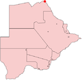
Kazungula District is a district of Zambia, located in Southern Province. The capital lies at Kazungula. As of the 2000 Zambian Census, the district had...
2 KB (57 words) - 18:00, 1 September 2022

Chikankata District Chirundu District Choma District Gwembe District Itezhi-Tezhi District Kalomo District Kazungula District Livingstone District Mazabuka...
11 KB (677 words) - 03:15, 15 July 2024
Kazungula, Zambia, a town Kazungula District, a district of Zambia Kazungula, Zimbabwe, a small settlement Kazungula Ferry Kazungula Bridge This disambiguation...
343 bytes (73 words) - 13:27, 24 October 2023

fifteen districts, namely, Chikankata District, Chirundu District, Choma District, Gwembe District, Itezhi-Tezhi District, Kalomo District, Kazungula District...
26 KB (2,266 words) - 06:27, 22 March 2024
Zambezi rivers. Kazungula is the site of border crossings to the town in Zambia, also called Kazungula, across the Zambezi by the Kazungula Bridge (previously...
3 KB (108 words) - 19:33, 27 June 2024

south-south-west for 80 kilometres (50 mi), through a narrow part of Kazungula District, through the Kebby Musokotwane Toll Plaza, to the city of Livingstone...
9 KB (990 words) - 17:06, 22 May 2024
constituency of the National Assembly of Zambia. It covers Kazungula and surrounding areas in Kazungula District of Southern Province. "Katombola | National Assembly...
2 KB (63 words) - 16:39, 21 December 2022
200km 124miles Mosetse Kazungula Bridge Livingstone The Mosetse–Kazungula–Livingstone Railway is a prospected 430 kilometres (270 mi) cape gauge international...
3 KB (291 words) - 11:29, 21 May 2024

then flows into the Zambezi just above the former Kazungula Ferry (map, 9), now replaced by the Kazungula Bridge. In years when the Okavango experiences...
9 KB (738 words) - 09:44, 1 August 2024

village Bradfield Dakamela Dete Eastnor Inyati Jotsholo Kamativi Kariyangwe Kazungula Lonely Mine Matetsi Mbuma Mlibizi Mpandamatenga Nkayi Nyamandhlovu Queen's...
9 KB (324 words) - 12:49, 16 May 2024
that a quadripoint existed. As a result, South Africa claimed that the Kazungula Ferry, which links Botswana and Zambia at the quadripoint, was illegal...
51 KB (5,496 words) - 16:34, 1 July 2024
Enclave and exclave (redirect from Inaccessible district)
a short distance, then returns to Bartın. 1km 0.6miles 4 3 2 1 The Kazungula Bridge connects Zambia and Botswana in Southern Africa. The shared border...
98 KB (11,749 words) - 13:17, 24 July 2024
Musokotwane Toka Leya August Kasanga Makonda Kazungula Chief Moomba Nkoya September Guta Bweenza Bwe Kazungula Chief Nyawa Tonga September Ikubi Lya BanaMunyati...
7 KB (23 words) - 07:44, 24 May 2024
African Wildlife Foundation (section Kazungula)
of modern new buildings for the Lupani community school were opened in Kazungula, built by the AWF at a cost of US$250,000. The new school has six classrooms...
38 KB (3,490 words) - 13:41, 30 July 2024
Kasama Kasempa Kashikishi Kataba Katete Kawambwa Kazembe (Mwansabombwe) Kazungula Luangwa Luanshya Lufwanyama Lukulu Lundazi Maamba Macha Mission Mansa...
4 KB (163 words) - 11:12, 14 July 2024

(same gauge) Zimbabwe (same gauge) Zambia - being built at Kazungula Bridge in Kazungula. Namibia Mozambique Botswana had 584,000 locally registered...
18 KB (1,531 words) - 06:38, 9 June 2024

Kasane (category North-West District (Botswana))
confluence with the Chobe River. Here the Kazungula border post serves the Kazungula Bridge crossing to Kazungula in Zambia on the north bank of the Zambezi...
7 KB (474 words) - 12:02, 2 March 2024
borders between two countries: Botswana – Zambia: 155 m (509 ft) near Kazungula UK (Gibraltar) – Spain: 1.22 km (0.76 mi) Kingdom of Denmark (Greenland)...
68 KB (2,334 words) - 04:29, 19 June 2024
and Zimbabwe (including day trips to Chobe National Park in Botswana at Kazungula). In second phase Namibia, Angola and Botswana are expected to join the...
12 KB (633 words) - 21:41, 8 May 2024
Bridge". "Luangwa Bridge". "Chirundu Bridge". "Victoria Falls Bridge". "Kazungula Bridge". "Katima Mulilo Bridge". Others references Thompson, F.B. (April...
13 KB (552 words) - 01:33, 26 August 2023
Science et Industrie S.A (ed.). "Le pont multi-haubané de Kazungula sur le Zambèze" [The Kazungula multiple-cable-stayed bridge over the Zambezi] (PDF). Revue...
4 KB (238 words) - 05:51, 2 April 2023
connects the Caprivi Strip of Namibia as well as Zambia with Nata via Kazungula. It is an important route used by motorists from Zambia and the Caprivi...
3 KB (292 words) - 21:22, 5 July 2024

in the north and Simonga in the southwest. The Zambia road of M10 from Kazungula and Sesheke in the west, after passing through Simonga, reaches a junction...
5 KB (311 words) - 12:46, 29 March 2024

WaterAid (section Efforts in Monze District)
operations to seven districts in the country, five of which are in the Southern Province (Monze, Siavonga, Namwala, Itezhitezhi and Kazungula) while the other...
34 KB (3,633 words) - 10:29, 15 July 2024
P12= ( Makuti-Kariba) • P13=( Chegutu-Chinhoyi ) • P14= ( Victoria Falls-Kazungula) (Source: [Map 9.2 Road Transport Network of Zimbabwe.]) Secondary roads...
10 KB (1,149 words) - 02:35, 15 June 2024

Bulawayo). The M10 road connects westwards to Kazungula (where the Kazungula Bridge, formerly the Kazungula Ferry, connects with the border into Botswana)...
35 KB (3,144 words) - 03:34, 19 May 2024

Chobe (Botswana constituency) (category Botswana constituencies in the Chobe District)
of Chobe District and contains the following villages: Kasane Lesoma Mabele Muchenje Pandamatenga Kachikau Kavimba Satau Parakarungu Kazungula Key: BDP...
8 KB (187 words) - 18:23, 1 March 2024
Kaoma, Zambia (section New district hospital)
surrounding areas such as Mumbwa, Mulobezi, Kazungula, Mungulula (Mongu), Kalabo, Lukulu amongst other districts. The Nkoya people celebrate an annual traditional...
14 KB (751 words) - 04:03, 30 July 2024

sacred. At Lokoja, Nigeria, the Benue River flows into the Niger. At Kazungula in Zambia, the Chobe River flows into the Zambezi. The confluence defines...
31 KB (3,509 words) - 01:44, 2 June 2024