
Kentucky Route 107 (KY 107) is a 56.907-mile-long (91.583 km) east–west state highway in west–central Kentucky. The western (southern) terminus of the...
11 KB (653 words) - 13:50, 19 February 2024

highway that runs from Kentucky Route 32 just east of Elliottville to Kentucky Route 7 at Green via Ault and Gimlet. Kentucky Route 505 (KY 505) is a 18...
113 KB (5,096 words) - 23:22, 14 May 2024

help) Template:Attached KML/Kentucky Route 103 KML is not from Wikidata Kentucky Route 103 is a 18.086-mile-long (29.107 km) rural secondary highway in...
107 KB (11,131 words) - 03:42, 17 August 2024

secondary highway through a February 21, 2011, official order. Kentucky Route 489 is a 4.107-mile-long (6.610 km) supplemental road in eastern Grant County...
131 KB (12,134 words) - 17:05, 29 April 2024

Street). Kentucky Route 287 is a 6.188-mile-long (9.959 km) rural secondary highway in western Christian County. The highway begins at KY 107 (Lafayette...
91 KB (9,054 words) - 18:30, 9 May 2024

have portions within the State Primary and State Secondary systems. Kentucky Route 301 is a 6.210-mile-long (9.994 km) rural secondary highway in eastern...
95 KB (9,567 words) - 02:37, 9 July 2024

Virginia, at its parent route U.S. Route 60 at Ocean View to Frankfort, Kentucky, intersecting its parent route once again. It passes through the states...
13 KB (1,254 words) - 22:23, 4 August 2024

in Christian County, Kentucky, United States. It is concentrated around the intersection of Kentucky Route 107 and Kentucky Route 117, southwest of Hopkinsville...
2 KB (139 words) - 05:26, 4 November 2023

Illinois to U.S. Route 25 in Mount Vernon, Kentucky. In the state of Illinois, U.S. 150 runs from the Quad City International Airport at U.S. Route 6 southeast...
31 KB (997 words) - 05:11, 21 October 2023

S. Route 25E (US 25E) is the eastern branch of US 25 from Newport, Tennessee, where US 25 splits into US 25E and US 25W, to North Corbin, Kentucky, where...
88 KB (7,631 words) - 09:31, 8 September 2024

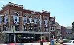
National Register of Historic Places. LaFayette is located along Kentucky Route 107 in the southwestern corner of Christian County, 18 miles (29 km) southwest...
9 KB (694 words) - 16:03, 15 November 2023
Route 107 Indiana State Road 107 (former) Iowa Highway 107 K-107 (Kansas highway) (former) Kentucky Route 107 Louisiana Highway 107 Maine State Route...
5 KB (377 words) - 21:29, 22 August 2024

Kentucky Route 272 (KY 272), KY 695, KY 107, and KY 109. This by-pass route also serves as the truck route, therefore it is also signed as U.S. Route...
19 KB (808 words) - 19:04, 17 April 2024

of Fruit Hill and west of its terminus at KY 107 (Greenville Road) north of Bluff Spring. Kentucky Route 813 is a 16.593-mile-long (26.704 km) rural secondary...
19 KB (1,904 words) - 09:41, 22 September 2023

U.S. Route 31E (US 31E) is the eastern parallel route for U.S. Highway 31 from Nashville, Tennessee, to Louisville, Kentucky. US 31E begins as the Ellington...
33 KB (1,340 words) - 10:11, 1 September 2024

established KY 2706 through an April 8, 1987, official order. Kentucky Route 2708 (KY 2708) is a 0.107-mile (0.172 km) supplemental road that begins from a junction...
41 KB (4,089 words) - 21:34, 16 August 2024

Kentucky Route 80 (KY 80) is a 483.55-mile-long (778.20 km) state highway in the southern part of the U.S. state of Kentucky. The route originates on...
64 KB (1,742 words) - 04:20, 25 July 2024

Kentucky Route 15 begins at a junction of US 119/Corridor F & Business KY 15 in Whitesburg, and terminates in Winchester at US 60. It is a major route...
20 KB (556 words) - 23:56, 8 April 2023

Sweet Owen. Kentucky Route 1293 is a 5.112-mile-long (8.227 km) rural secondary highway in northwestern Logan County. The highway begins at KY 107 (Deer Lick...
56 KB (5,375 words) - 23:27, 12 May 2024
U.S. Route 68 (US 68) is a United States highway that runs for 560 miles (900 km) from northwest Ohio to Western Kentucky. The highway's western terminus...
71 KB (1,848 words) - 21:59, 31 August 2024

Kentucky Route 90 (KY 90) is a major east–west state highway in southern Kentucky. The route is 134.734 miles (216.833 km) long, and it traverses Barren...
35 KB (2,446 words) - 21:13, 14 May 2024

Route 22, whose continuation into Kentucky Bend at one time was signed as Kentucky State Route 313. According to the U.S. Census Bureau, the Kentucky...
14 KB (1,128 words) - 21:07, 7 September 2024

U.S. Route 42 (US 42) is an east–west United States highway that runs southwest–northeast for 350 miles (560 km) from Louisville, Kentucky to Cleveland...
51 KB (2,236 words) - 16:34, 31 August 2024

Kentucky Route 259 (KY 259) is a 95.91-mile-long (154.35 km) state highway that traverses five counties in west-central Kentucky. KY 259's southern terminus...
18 KB (1,075 words) - 19:20, 10 October 2024

KY 107 in downtown Hopkinsville via Church Hill. The entire route is in Christian County. KML file (edit • help) Template:Attached KML/Kentucky Route 695...
2 KB (103 words) - 17:55, 16 February 2024

in Kentucky to Interstate 64 at Charleston, West Virginia. In Kentucky, US 119 is a two- and four-lane highway running from Pineville at U.S. Route 25E...
55 KB (2,217 words) - 16:55, 3 June 2024

County, Kentucky, in the United States. The population was 264 at the 2010 census. Ewing is located in western Fleming County. Kentucky Route 165 passes...
7 KB (570 words) - 14:50, 16 July 2023
County, Kentucky, United States. It is the fourth-most populous city in the state. Owensboro is located on U.S. Route 60 and Interstate 165 about 107 miles...
40 KB (3,684 words) - 02:50, 21 September 2024

U.S. Route 23 (US 23) is a 157.765-mile-long (253.898 km) United States Numbered Highway in the state of Kentucky. It travels from the Virginia state line...
20 KB (380 words) - 23:06, 8 March 2024

Kentucky Route 55 (KY 55) is a 140.858-mile-long (226.689 km) state highway in the U.S. Commonwealth of Kentucky. The route originates at a junction with...
26 KB (1,411 words) - 19:03, 26 October 2023