
Kentucky Route 29 (KY 29) is an 11.324-mile-long (18.224 km) state highway located entirely within Jessamine County in the U.S. state of Kentucky. The...
6 KB (491 words) - 17:49, 16 February 2024
Kentucky Route Zero is a point-and-click adventure interactive fiction game developed by Cardboard Computer and published by Annapurna Interactive. The...
38 KB (4,181 words) - 20:37, 28 July 2024

highway that runs from Kentucky Route 32 just east of Elliottville to Kentucky Route 7 at Green via Ault and Gimlet. Kentucky Route 505 (KY 505) is a 18...
113 KB (5,096 words) - 23:22, 14 May 2024

have portions within the State Primary and State Secondary systems. Kentucky Route 400 is a 1.377-mile-long (2.216 km) supplemental road in the city of...
131 KB (12,134 words) - 17:05, 29 April 2024

• help) Template:Attached KML/Kentucky Route 103 KML is not from Wikidata Kentucky Route 103 is a 18.086-mile-long (29.107 km) rural secondary highway...
107 KB (11,131 words) - 03:42, 17 August 2024
Adair County, in the U.S. state of Kentucky. It is located at the junction of Kentucky Route 206 and Kentucky Route 76. Its elevation is 705 feet (215 m)...
9 KB (644 words) - 20:07, 25 June 2024

systems. Kentucky Route 600 is a 2.728-mile-long (4.390 km) state highway in Muhlenberg County that runs from Kentucky Route 831 to Kentucky Route 171 northwest...
109 KB (6,845 words) - 04:26, 3 May 2024

within the State Primary and State Secondary systems. Kentucky Route 200 is a 18.041-mile-long (29.034 km) rural secondary highway that traverses far southeastern...
91 KB (9,054 words) - 18:30, 9 May 2024

have portions within the State Primary and State Secondary systems. Kentucky Route 301 is a 6.210-mile-long (9.994 km) rural secondary highway in eastern...
95 KB (9,567 words) - 02:37, 9 July 2024

segment in Kentucky is the second-shortest, at 191.78 miles (308.64 km) long. I-75 parallels the older U.S. Route 25 (US 25) and U.S. Route 25E (US 25E)...
74 KB (6,312 words) - 02:27, 11 September 2024

have portions within the State Primary and State Secondary systems. Kentucky Route 1508 is a 7.662-mile-long (12.331 km) rural secondary highway in southern...
53 KB (5,054 words) - 21:54, 20 January 2024

a more westerly route between Nashville, Tennessee, and Hopkinsville, Kentucky. The current US 41 was US 241. In 1930, the two routes became US 41W and...
40 KB (4,259 words) - 16:41, 7 September 2024

Kentucky Route 90 (KY 90) is a major east–west state highway in southern Kentucky. The route is 134.734 miles (216.833 km) long, and it traverses Barren...
35 KB (2,446 words) - 21:13, 14 May 2024

Kentucky Route 15 begins at a junction of US 119/Corridor F & Business KY 15 in Whitesburg, and terminates in Winchester at US 60. It is a major route...
20 KB (556 words) - 23:56, 8 April 2023

Harlan County before ending in Big Laurel at KY 221. Kentucky Route 2009 is an 18.028-mile long (29.013 km) rural secondary highway in Leslie and Harlan...
68 KB (6,138 words) - 17:15, 12 July 2024

McCreary County that runs from Kentucky Route 92 east of Smith Town to Kentucky Route 1651 southwest of Whitley City. Kentucky Route 702 (KY 702) is a 2.855-mile-long...
58 KB (3,524 words) - 23:33, 29 January 2023

controlled-access bypass and continues south of the city toward the Kentucky River. Kentucky Route 29 is an east–west two-lane highway that stretches from the western...
20 KB (1,827 words) - 02:54, 5 August 2024

U.S. Route 31E (US 31E) is the eastern parallel route for U.S. Highway 31 from Nashville, Tennessee, to Louisville, Kentucky. US 31E begins as the Ellington...
33 KB (1,340 words) - 10:11, 1 September 2024

U.S. Route 68 (US 68) is a United States highway that runs for 560 miles (900 km) from northwest Ohio to Western Kentucky. The highway's western terminus...
71 KB (1,848 words) - 21:59, 31 August 2024

Illinois to U.S. Route 25 in Mount Vernon, Kentucky. In the state of Illinois, U.S. 150 runs from the Quad City International Airport at U.S. Route 6 southeast...
31 KB (997 words) - 05:11, 21 October 2023

terminus of the route is at Kentucky Route 1247 in Somerset. The northernmost terminus is at U.S. Route 27 Business and Kentucky Route 29 in Nicholasville...
8 KB (266 words) - 19:24, 21 June 2023

Kentucky Route 70 (KY 70) is a long east-east state highway that originates at a junction with U.S. Route 60 (US 60) in Smithland in Livingston County...
58 KB (3,304 words) - 18:56, 22 May 2024

terminus at KY 187 (Sunfish Road) north of Sunfish. Kentucky Route 1083 is a 18.081-mile-long (29.099 km) rural secondary highway in western Warren County...
56 KB (5,375 words) - 23:27, 12 May 2024

U.S. Route 60 (US 60) is a major U.S. Highway in the American state of Kentucky. In the early days of the U.S. Highway System, US 60 was originally to...
75 KB (1,843 words) - 22:34, 30 August 2024

Virginia, at its parent route U.S. Route 60 at Ocean View to Frankfort, Kentucky, intersecting its parent route once again. It passes through the states...
13 KB (1,254 words) - 22:23, 4 August 2024
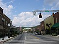
London is a home rule-class city in Laurel County, Kentucky, in the United States. It is the seat of its county. The population was 8,053 at the time of...
21 KB (1,514 words) - 14:17, 22 August 2024

Kentucky Route 22 (KY 22) is a 121.213-mile-long (195.073 km) east–west highway running from the eastern suburbs of Louisville to an unincorporated place...
16 KB (319 words) - 20:43, 11 September 2023

Kentucky (US: /kənˈtʌki/ kən-TUK-ee, UK: /kɛn-/ ken-), officially the Commonwealth of Kentucky, is a landlocked state in the Southeastern region of the...
215 KB (19,346 words) - 15:26, 17 September 2024
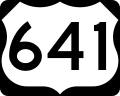
U.S. Route 641 (US 641) is a U.S. Route in Tennessee and Kentucky. It runs for 165.45 miles (266.27 km) from US 64 south of Clifton, Tennessee to an intersection...
21 KB (853 words) - 14:16, 18 February 2024

U.S. Route 31W (US 31W) is the westernmost of two parallel routes for U.S. Route 31 from Nashville, Tennessee to Louisville, Kentucky. Tennessee State...
32 KB (1,478 words) - 06:46, 25 February 2024