
related to Kilpisjärvi. Wikivoyage has a travel guide for Kilpisjärvi. Kilpisjärvi tourist information Tundrea, Kilpisjarvi Holiday Resort Kilpisjärvi school...
12 KB (530 words) - 15:14, 27 May 2024

[citation needed] Kilpisjärvi–Alajärvi in Järviwiki Web Service. Finnish Environment Institute. Retrieved 2014-03-21. (in English) sv:Kilpisjärvi (sjö) Suomen...
3 KB (130 words) - 21:01, 26 May 2024

biological research station in Kilpisjärvi. The University of Oulu runs the KAIRA radio telescope facility at Kilpisjärvi as well. Healthcare is organised...
47 KB (4,494 words) - 01:20, 30 June 2024

practice at the time. A 55 km (34 mi) trekking path leads from Saana, Kilpisjärvi to Halti. An easier route goes from a local road (open in summer only)...
7 KB (516 words) - 21:56, 25 July 2024
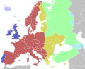
the whole of Europe The northwesternmost part of Finland, including Kilpisjärvi and Kaaresuvanto. The Russian exclave of Kaliningrad Oblast, excluding...
20 KB (2,088 words) - 14:10, 8 August 2024

from Kilpisjärvi in Finland along a hiking trail in the Malla Strict Nature Reserve. In summertime, it can be reached by public boat from Kilpisjärvi plus...
6 KB (526 words) - 16:27, 27 April 2024

Käsivarsi Wilderness Area, about 45 kilometres (28 mi) from the village Kilpisjärvi within the municipality of Enontekiö. It is accessible by following the...
1 KB (133 words) - 12:59, 9 February 2023

metres (3,376 ft) above sea level and 556 m (1,824 ft) above the adjacent Kilpisjärvi lake. Geologically it is part of the Scandinavian Mountains, and is made...
4 KB (199 words) - 18:09, 17 May 2024

is 1,410 kilometres (880 mi). E8: Tromsø – Nordkjosbotn – Skibotn – Kilpisjärvi – Kaaresuvanto – Muonio – Tornio – Keminmaa – Kemi – Oulu – Liminka –...
4 KB (281 words) - 22:45, 13 May 2024

things to do in the area, and is on the E8 highway which goes north to Kilpisjärvi. The municipality is unilingually Finnish, unlike many towns on the Finland–Sweden...
10 KB (464 words) - 05:23, 24 June 2024

original on 2019-02-23. Retrieved 2016-12-13. Kilpisjärvi Biological Station University of Helsinki - Kilpisjärvi Biological Station Kiruna Atmospheric and...
37 KB (986 words) - 13:29, 24 February 2024

G7es torpedo. Some German positions defending Lyngen extended over to Kilpisjärvi on the Finnish side of the border, but no major activity occurred. The...
42 KB (5,177 words) - 12:22, 25 July 2024

cover starts to melt fast. The thickest snow cover ever was measured in Kilpisjärvi on 19 April 1997 and it was 190 cm. The annual mean temperature varies...
70 KB (2,739 words) - 16:36, 3 June 2024

northwards to Oulu and Rovaniemi. From there, the lines continue northwest to Kilpisjärvi and Tromsø or north towards Utsjoki and Nordkapp. The company is the...
2 KB (204 words) - 00:25, 8 June 2024

Keurusselkä, Keyritty, Kiantajärvi (1), Kiantajärvi (2), Kiesimä, Kiitämä, Kilpisjärvi – Alajärvi, Kiteenjärvi, Kiuruvesi, Kivesjärvi, Kivijärvi (1), Kivijärvi...
10 KB (536 words) - 22:13, 25 July 2024

tripoint at the border of Norway, located in the Koltajärvi lake near Kilpisjärvi, which is also the northernmost point of Sweden. The first 230 m (750 ft)...
13 KB (1,527 words) - 15:30, 24 July 2024

on 24 June 2013. "Are 2012 DA14 and the Chelyabinsk meteor related?". Kilpisjärvi Atmospheric Imaging Receiver Array. Finland: Sodankylä Geophysical Observatory...
106 KB (8,480 words) - 03:08, 2 August 2024

they pulled him on a sled across Finland and into neutral Sweden. From Kilpisjärvi, in northern Finland, Baalsrud was collected by a Red Cross seaplane...
11 KB (1,282 words) - 12:42, 19 June 2024

majority of your time in the far West of Enontekiö, in the village of Kilpisjärvi. Hetta is a popular tourist destination for cross country skiers and...
6 KB (220 words) - 15:06, 27 May 2024

"Hytter - UT.no". www.ut.no. Archived from the original on 2017-01-07. "Kilpisjärvi - Kautokeino, about 190 km - Nationalparks.fi". www.nationalparks.fi...
16 KB (692 words) - 17:38, 30 June 2024
Sweden. Roslagsleden is part of the European route E6 which goes from Kilpisjärvi in the north to Greece in the south. The trail is split up in 11 sections...
2 KB (150 words) - 13:24, 26 May 2024

kept old number) – 1,410 km (880 mi): Tromsø – Nordkjosbotn – Skibotn – Kilpisjärvi – Kolari – Tornio – Kemi – Oulu – Kokkola – Vaasa – Pori – Turku – 910 km...
89 KB (5,744 words) - 14:11, 13 August 2024
hairbrush Mia Hundvin 5 November 2020 (2020-11-05) 8 "Kilpisjärvi, har du vært der?" Kilpisjärvi, have you been there? Jon Almaas 12 November 2020 (2020-11-12)...
23 KB (548 words) - 00:11, 5 June 2024

highest peak Halti, about 1324 masl, is located in northern part of area. Kilpisjärvi-Halti hiking route is 55km long. 800km long Nordkalottleden Trail also...
3 KB (195 words) - 21:05, 2 December 2021
which is drained after a 55 km crossing by the Torne (470 km). Lake Kilpisjärvi is drained, about 30 km from its headwater's most distant source, by...
261 KB (9,276 words) - 20:32, 7 August 2024

The Kilpisjärvi Atmospheric Imaging Receiver Array (KAIRA) is an astronomical observatory operated by the Sodankylä Geophysical Observatory on behalf...
5 KB (539 words) - 20:20, 21 September 2021

The International Tundra Experiment (ITEX) is a long-term international collaboration of researchers examining the responses of arctic and alpine plants...
77 KB (9,657 words) - 16:40, 22 April 2024

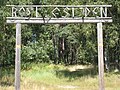
Trilingual international border sign (Finnish, Swedish and Northern Sámi) on the E8 road at the border between Norway and Finland, at Kilpisjärvi, Finland...
132 KB (10,379 words) - 09:13, 5 August 2024
Arab Emirates Masafi Ras al-Khaimah and Fujairah 567 1,863 157 Finland Kilpisjärvi Lapland 490 1,607 excursionmap.fi 158 Mauritania Zouérat Tiris Zemmour...
34 KB (563 words) - 09:29, 27 July 2024

Line—although some entrenched German forces still remained in Finland at Kilpisjärvi in the corridor leading to the border tripoint between Norway, Sweden...
11 KB (1,226 words) - 17:53, 9 August 2024