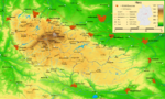
The Kloppstert is a hill, roughly 553 metres (1,814 ft) high, in the southwestern Harz in Lower Saxony, Germany. In the topographical map printed in 1978...
3 KB (224 words) - 18:11, 8 May 2023
Langental ("long valley"). To the northwest the Adlersberg transitions to the Kloppstert and the Fissenkenkopf hills. Other nearby peaks are the Pagelsburg 1.2 km...
2 KB (104 words) - 10:58, 21 February 2018
527 metres high and is the western extension of the Adlersberg and the Kloppstert hills. Topographic map 1:25,000 series, No. 4328 Bad Lauterberg im Harz...
1 KB (55 words) - 11:02, 21 February 2018
name of Klappstept according to references in the Wikipedia article, Kloppstert, accessed on 27 July 2012 Elevation of – Pagelsburg according to Einzelnachweise...
175 KB (892 words) - 00:00, 11 January 2024
district, Harz Franzosenkopf (562 m), Osterode am Harz district, Harz Kloppstert (553 m), Osterode am Harz district, Harz Eichelnkopf (545.7 m), Osterode...
39 KB (3,193 words) - 13:33, 10 October 2023