
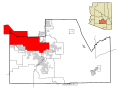
Komatke (O'odham: Komaḍk) is a census-designated place in Maricopa County, Arizona, United States. The area currently comprising the census-designated...
9 KB (479 words) - 17:12, 19 April 2024
New York City, New York (closed 1991) St. John's Indian School – Komatke, Arizona (closed 1993) St. Lucy School – Manhattan, New York City, New York...
38 KB (3,473 words) - 03:00, 10 April 2024

Youngtown Aguila Anthem Arlington Circle City Citrus Park Gila Crossing Kaka Komatke Maricopa Colony Morristown New River Rio Verde St. Johns Sun City Sun City...
58 KB (4,075 words) - 21:48, 26 June 2024

census-designated place (CDP) in Maricopa County, Arizona, United States, within the Gila River Indian Community south of Komatke. The population was 636 at the 2020...
6 KB (253 words) - 05:43, 10 July 2023
Phoenix Union High School, Phoenix (1982) St. Johns Indian School, Laveen/Komatke (1976) St. Paul's Preparatory Academy, Phoenix (December 2009) Scottsdale...
30 KB (2,132 words) - 16:54, 26 June 2024

Ahwatukee Foothills Village and the Gila River Indigenous Community. Near Komatke, the freeway curves northward and cuts through the western foothills of...
45 KB (3,333 words) - 20:50, 24 May 2024

Gila River (category Arizona placenames of Native American origin)
044 km) tributary of the Colorado River flowing through New Mexico and Arizona in the United States. The river drains an arid watershed of nearly 60,000...
23 KB (2,536 words) - 01:29, 24 June 2024

Phoenix metropolitan area (redirect from Phoenix, Arizona metropolitan area)
Lakes pop. 14,868 Under 10,000 inhabitants Aguila Arlington Circle City Komatke Liberty Morristown Palo Verde Rio Verde Tonopah Tortilla Flat Waddell Wintersburg...
42 KB (3,641 words) - 02:55, 9 May 2024

the Gila River. It is bordered to the southeast by the communities of Komatke and Gila Crossing. Downtown Phoenix is 15 miles (24 km) to the northeast...
4 KB (187 words) - 21:40, 13 July 2023
Gila River Indian Community (redirect from Gila River Indian Community of the Gila River Indian Reservation, Arizona)
districts along the Gila River and its largest communities are Sacaton, Komatke, Santan, and Blackwater. Tribal administrative offices and departments...
14 KB (1,326 words) - 22:58, 12 June 2024

Laveen, Phoenix (redirect from Laveen, Phoenix, Arizona)
affiliated with the Bureau of Indian Education, is in Komatke, with a Laveen address. Laveen is in Arizona's 7th Congressional District, and is served by Representative...
42 KB (4,093 words) - 09:42, 26 June 2024

Colony with Komatke. "2021 U.S. Gazetteer Files: Arizona". United States Census Bureau. Retrieved May 17, 2022. "Maricopa Colony CDP, Arizona: 2020 DEC...
5 KB (188 words) - 05:43, 12 July 2023

Sierra Estrella (category Wilderness areas of Arizona)
Yavapai: Wi:kchasa) is a mountain range located southwest of Phoenix, Arizona. Much of the range falls within the Gila River Indian Reservation, but...
7 KB (711 words) - 12:37, 25 February 2024

Akimel O'odham (category Native American history of Arizona)
District #4 – Santan, District #5 – Vah Ki (Casa Blanca), District #6 – Komatke (Sierra Estrella Mountains), and District #7 – Maricopa Colony. The Akimel...
24 KB (3,212 words) - 20:18, 29 May 2024
1165 95.65% Peach Springs CDP 1121 1068 95.27% Pinon CDP 1113 1039 93.35% Komatke CDP 1032 969 93.90% Hotevilla-Bacavi CDP 1011 988 97.73% Rainbow City CDP...
50 KB (115 words) - 17:05, 23 January 2024

United States Department of the Interior. "Feature Detail Report for: Komatke Census Designated Place". Geographic Names Information System. United States...
9 KB (850 words) - 19:11, 18 February 2023

Valley Metro Bus (redirect from List of bus routes in Phoenix, Arizona)
Metro Bus is a transit bus system for public transport in Maricopa County, Arizona, United States. In 2023, the system had a ridership of 24,215,700, or about...
107 KB (2,640 words) - 19:53, 4 June 2024

parish church with a resident pastor was 13 mi (21 km) to the northwest in Komatke. A Franciscan friar named Father Antoine ran the St. Francis in the Desert...
15 KB (1,430 words) - 00:29, 6 September 2023

Roman Catholic Diocese of Phoenix (category Catholic Church in Arizona)
Our Lady of Guadalupe Church – Guadalupe St. John the Baptist Church – Komatke Gila River Indian Community Mission All Saints Church – Mesa Christ the...
41 KB (3,468 words) - 21:09, 31 May 2024
Diego, St. Boniface School in Banning, and St. John's Mission School in Komatke. When Bishop Salpointe opened St. Mary's Hospital in Tucson in 1880, health...
18 KB (2,255 words) - 04:56, 31 March 2024
Census defines 360 census-designated places or CDPs within the state of Arizona, with a combined population of 894,461 accounting for 14% of the state...
76 KB (266 words) - 17:14, 19 April 2024

Chickasaw Cultural Center, Ada, Oklahoma (2002–04); and the Komatke Health Center, Gila, Arizona (2006–07). Sakiestewa's experience with public art and her...
10 KB (1,114 words) - 17:19, 9 June 2024